`osm-river-basins`: Website to show how are rivers in OSM connected

haha! yous are quicker than me! I’ve fixed that problem.

I’ve moved it to a proper site. The web address is now WaterwayMap.org. Alas I discovered that if you rename the Github project (it’s now [amandasaurus/waterwaymap.org)[GitHub - amandasaurus/waterwaymap.org: WaterwayMap.org | River Basins from OpenStreetMap]) it doesn’t redirect a GH pages site. I’ve bodged up a solution.

Happy Mapping

1 Like

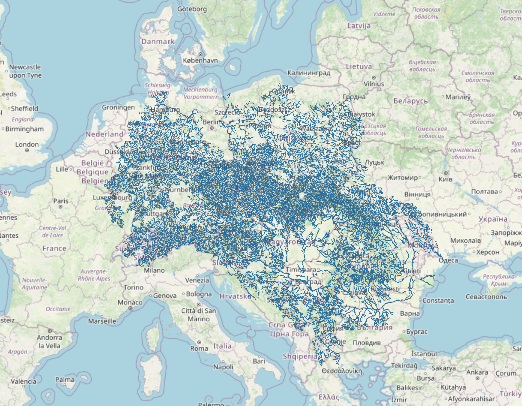
I’d long known that the Rhine & Danube were connected via the Rhine–Main–Danube Canal, but when I made the “only rivers & streams” view, I was surprised to see this, the Rhine & Danube joined as one.

map of europe showing the rhine & danube as one big blob

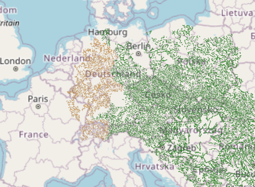
Thanks @mcliquid (on mastodon) for finding a few underground overflow pipes in the Tirol/Voralberg Alps which were incorrectly tagged as streams (and a little help from my QGIS). After those little changes, we parted the waters, and spearated the 2nd & 11th largest rivers in Europe. :grin:

a map of europe with the rhine & danube waterbasins being separated

If you show OSMers mistakes in OSM, they will fix it. People using OSM data leads to people fixing & improving OSM data leads to people using OSM leads to …

7 Likes

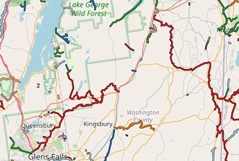
Since you released this project I’ve become quite interested in connecting up the Lake Champlain watershed in my local area. However, I’ve discovered that the Champlain Canal connects it to the Hudson River watershed. The canal apparently connected up a number of smaller rivers and streams along it it’s path as well so now these waterways flow into the canal and are isolated from the rest of the river & stream network.


I wonder if there is some way we can map which watershed a canal is part of. Or map the divide between watersheds on a canal. Hmm.

I did connect the rivers//streams for the Lake Champlain / Richelieu river watershed. But I did not connect the tributaries to the canal.

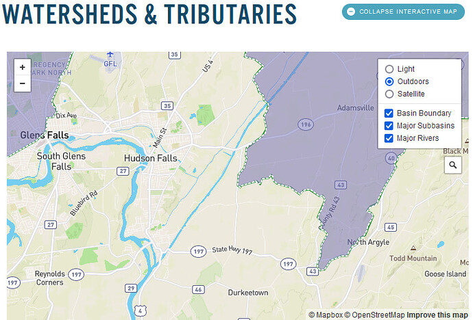
Revisiting infos, the Lake Champlain Basin Atlas detailed map shows that the divide point between Lake Champlain and Hudson river watersheds is very close to Hudson falls, the south poiint of the canal. .

See poster https://lcbpatlas.wpenginepowered.com/wp-content/uploads/2018/04/Basin_Poster_2016.png
On the right of the website page, we can view a detailed map based on OpenStreetMap.
Watersheds - Lake Champlain Basin Atlas

I did find few infos about water management of the canal. There is the wiki page about the Glen Falls feeder canal. There is also the study about Preventing the Transfer of Invasive Species via the Champlain Canal - PRINCETON HYDRO
It is said :
« The primary focus of this study was located at the summit canal between locks C-8 and C-9, as this location is the natural point of separation for the watersheds. This is where (the summit) the Glens Falls Feeder Canal supplies Hudson River water to the height of the Champlain Canal to maintain water levels for navigability that flows south back to the Hudson, but also north and into the Champlain drainage. »

I suggest that we cut the canal at the watersheds divide point 43.32216/-73.52235 between locks C-8 and C-9 and orient the canal waterway in the respective orientation of each basin.

Good suggestion. I have done this. I’m not sure it will be entirely clear to future mappers why the direction changes in this specific spot. Seems like we need some tag like mountain_pass to indicate the high point, but for canals.

2 Likes

Yes, the same when part of a river is derived to an other watershed with a dam or canal. It could be something like node waterway=watershed_divide or similar expression.

I added to the node description : Divide point between Lake Champlain and Hudson river watersheds. Waterflow is oriented in direction of each watershed.

2 Likes

On my view here, it also seems that Rhine and Rhone are connected. Is it a well known fact ?

Ah no, with only 5 colors they’re not !
May I suggest 1) more colors, 2) a topo background (OpenTopoMap ?)

Can see it coming with OpenTopomap, pipelines with flow direction uphill. Yes they do, pumped up with excess power to fill an uphill reservoir and then used to drive an hydroelectric plant when there is need. Energy guys I think call it peak-shaving.

I am now confused why Wisła river system in Poland is supposedly connected with Danube…

Also, Dniester and Danube watersheds are connected somewhere.

Axios and Danube watersheds are connected because of the Nerodimka river bifurcation. But if we want to fix this, we will have to take river and stream directions into account.

If one of the branches of the bifurcation was a man-made derivation, you can specify waterway=canal

Nope, both natural.

Would you mind share your way to identify “the shortest way” so that we can reproduce this calculation you did? That would be awesome! I’ve QGIS installed but never worked with it in detail tbh.

1 Like

I’m sorry, I reread the wiki article, it seems it is in fact artificial. I’ll try to find out which part is artificial to fix this.

1 Like

Obligatory XKCD comic for this topic: xkcd: Dubious Islands :wink:

2 Likes

I’ve added a new view, which includes waterway and natural=water.

Any OSM ways, which have a waterway key, or natural=water, and share a node, will now be joined. The total length of the water systems is much less accurate now, but it means that rivers which are connected to the edge of a lake, or river area, will be connected together.

OSMers have various views on whether we should map rivers (or streams) through waterbodies (e.g. this thread). One reason for mapping through a water body is to make hydrological analysis easier, such as on WaterwayMap.org, but people (incl. me) are unsure when to map through a waterbody. My hope with this analysis is to support both mapping approach, and not force one.

Alas, many non-trivial lakes are mapped as multipolygon relations , and this code only looks at ways. :sob:

e.g. the big red Cogburn Creek in CA-BC area is correctly joined when when combining natural=water or waterway=*
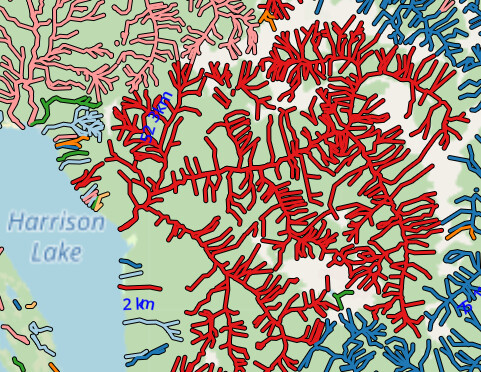
image

wheras with just waterway=* all the tributaries connected to the riverbank are not connected to each other.
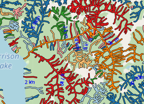
image

However they aren’t connected to the mulitpolygon relation for Harrison Lake).

You can see still find mapping mistakes. Here the Thompson River isn’t connected to the natural=water river bank. (which should be mapped).
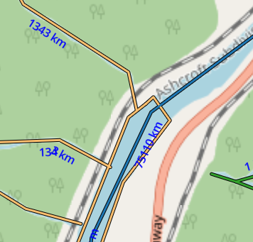
image

I’ll keep this view for now, although it is a little hefty to generate. Supporting relations is low on my priorities for now.

Happy Mapping. :slightly_smiling_face::world_map:

7 Likes

You could try to use the outer ways as areas and ignore the islets for this purpose. That does of course require some preprocessing, but it may be a simpler solution than trying to support the MPs in full.

1 Like

This is what I have done using ST_ExteriorRing in PostGIS IIRC (not quite sure where the output is located on my PC)

18 posts were split to a new topic: Drainage Divides the Danube