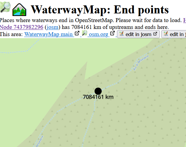
As of this writing, there’s a mysterious 7084161-km Endpoint in central Italy north of Florence, on an intermittent stream in an arid-ish area.
I tried to fix it through changeset 150532208, which involved merging several consecutive segments of the same named straeam. My prime suspect were two overlapping segments (like §) which I properly rearranged. Please check out if this has fixed the problem.
In the “natural” plane, rivers Weichsel and Donau still the same basin – all of the worlds seas Can this view ever render something like shown here Weichsel – Wikipedia ? The Watershed is so densely mapped, how to spot the culprit(s)?
Forgive me if this has been brought up, but I couldn’t seem to find it by searching: is rendering waterway=seaway intended? It results in some pretty silly “river” systems in Greece for example:
If the wiki is to be believed this tag should be removed on served ferry routes anyways, but irregardless, the tag in general seems to be a probably unwanted rendering for the purposes of the WaterwayMap.
@Hungerburg : I’d say no, OSM is too micro-mapped with real and existing links between ‘natural’ basins to achieve such a representation without some generalisation.
Taking out waterway=pressurizedrecently helped separate Rhine and Donau in the natural plane. Rendering waterway=seaway reminds on renderers and routers for which a highway=path is always 2m wide and paved. @PeachyOne file a github issue?
OSM tagging is rich vocabulary, it should be capable to distinguish natural from constructed features. Waterwaymap wants to help finding issues with inadequate tagging? I fully understand that it is not trivial to compute those junctions where two basins entangle. Crowd-source that?
Yeah, that would be cool… goes off hackin‘ New feature time! Go in settings on WaterwayMap.org, and turn on Frames. (direct link )
For each water basin/blob, it chooses a set of points at the edges, and draws a black line from each edge point to every other edge point. This shows how regions of the blob are connected.
It’s only available for the All Waterways and Natural Waterways maps, and only for waterway groups longer than 1,000,000 m long (→ code ). For my fellow data nerds : It’s the shortest path between all the convex hull of the points in the graph. I can do algorithms, but graphics are not my strong suit. Here’s the map style if anyone wants to send me a patch
I’d love to do a Proper Algorithm™ like Betweenness centrality, but I couldn’t generate it in a sensible time. So I invented this “Frames” idea. Let’s see if it’s useful. Like all WWM data, it’s calculated every day. If you fix one mapping mistake
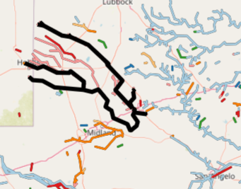
Yep, here’s that blob! (w. frames). This map includes canals, You can see many connections through France/Germany, and 2 routes through Poland and Austria.
Hi, look at this stream (see below). The water from it flows to both - southern and northern water basin. It is named “Dividend water”, so it is not necessary a mistake. Anyway it connects Danube to polish Gdansk:)
Hello Tomas, this is absolutely possible. In Bielefeld (Germany), we have a spring which feeds two similar named streams. But they’re running to opposite directions and are related to different bassins. While this was man made a few hundred years ago, even a constellation by nature is imaginable.
It’s not positively proven that Bielefeld not exists. And the court Landgericht Bielefeld (sic!) concluded in a - real - lawsuit that it’s obvious that Bielefeld exists. 'Bielefeld-Verschwörung': LG weist Millionen-Klage ab (German)
Those are false positives – the algorithm has issues when a natural waterway ends in an artificial one. In both cases above, a waterway=river transforms into a man_made=pipeline and waterway=canal respectively (from the looks of it, both should be man_made=pipeline instead).
It managed to find an end of 20,000 km in my neighborhood that I can’t fix – it’s an old riverbed connected to the main flow by an artificial canal with a pumping station.