I agree with JeroenHoek’s opinion, it’s frustrating even just reading issues of other proposal in osm-carto‘s repository that are constantly being rejected, and the general feeling of the whole project is that it’s resistant to change, whereas at the same time other osm-related projects (e.g., iD/Rapid) rarely have such poor and non-motivating feedback when faced with a specific problem, and osm-carto really doesn’t inspire confidence that “my efforts can be merged”.
Maybe the maintainers should try to maintain the project in a more agile way (of course, this is only a personal opinion, and does not mean that I force the maintainers to do so).
It’s unlikely that we’ll ever find a map rendering style that satisfies everyone (even the exact usage of labels is unlikely to be unified and consistent upon worldwide, or else how did driveway2 come about?) I’d like to know which of the current more dynamic forks might replace osm-carto as osmf default render style in the future (even if it might its visual presentation change quickly or have minor bugs).
–
Edit: Maybe someone who wants to build a fork can come forward and form a new team? Is this possible?
1 Like
Mammi71
(One feature, Six mappers and still More ways to map it)
85
Ich persönlich halte es zwar für “eigenartig”, dass man nur übereinander spricht (schreibt) statt miteinander, aber damit alle auf dem gleichen Kenntnisstand sind (gefunden via Wochennotiz):
english:
Personally, I think it is “strange” that people only talk (write) about each other instead of with each other, but so that everyone is on the same level of knowledge (found via weekly note):
It absolutely is possible; it just needs one or more people to step forward and Actually Do It. The technical bit (fork and modify the style) is easy. Lots of people have done that.
“Deciding what this new style is for” is somewhat harder, but also doable. The best way to learn what the problems actually are is to do it.
Once that’s done and the style has some sort of track record in doing what it set out to do better than OSM Carto, the next stage is the political bit, as outlined above.
Bluntly, the reason that we are where we are is because no-one had the appetite to do all of the above. If you want to be the person that proves me wrong, be my guest! Lots of people will be willing to help answer technical and even political questions, but what they’re not willing to do is own the project.
I am quite new to this whole discussion and also possibly quite naive. I can not figure out who you mean, even though I read the whole github issue and all of this thread. could you please point it out to me? I just read a lot of forum / wiki / github and I am really touched by the amount of effort of all these talented people working towards Free Open Source Software and the high values of community / commons. It is saddening me deeply to see these efforts kind of fruitless because something fundamental is not working. I just feel dumb because I can not figure out who or what is obstructing change.
A quick update: there has been a new layer released on osm.org called “Tracestack Topo”, and this one includes busways rendering. It is now my default layer. I wonder if at some point it will take “Standard” (i.e. Carto) position and be the default layer for osm webite visitors.
Pleasing to they eye with the elevation gradients for a particular audience such as those into mapping landscape, but then did ‘the fell test’. Blank. /o\
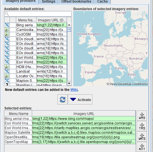
Indulge my wholesale ignorance, but how would I add a fell rendering map into JOSM. Got as far as this screen from which I added the OpenTopoMap which I like much because it gives the elevation gradients helping to decide the incline of roads but more importantly what direction waterways flow on sloped terrain.
Not sure if this is sarcasm, as you might have indicated at the end, but just in case:
As far as I can tell, Tracestrack’s style is currently a closed-source style, which makes it an unlikely candidate for a default layer. There’s some discussion about it here:
A different, open-source OSM Carto derivative has been proposed as a featured layer, though it’s still hosted by a third party:
If the same, todays newsletter 697 links to a new version announcement of Carto 5.8.0 imagico's Diary | OpenStreetMap Carto version v5.8.0 released | OpenStreetMap
Maybe this addresses something, anything to cheer one or few up. Sadly golf=hole no longer renders, used it 18 times on a course, have to retag as pin. Some railway stuff and flowerbeds now render \o/, mapped a few. Now we need fell in same variation or same as heath.
(not related to busways but) that statement isn’t true. Please read the link that you used yourself for details of what is actually happening. There are plenty of things to discuss where perhaps OSM Carto could perhaps be doing a better job than to accuse a style change of doing something that it has not done.