We are not aware of such an issue. I just tried and it loaded fast for me.
Please let us know if the issue persists, preferably on Github
I did experience such problems today around 18:20 CEST. Couldn’t upload a photo.
Edit: Well, it was uploaded but the UI hang up. ![]()
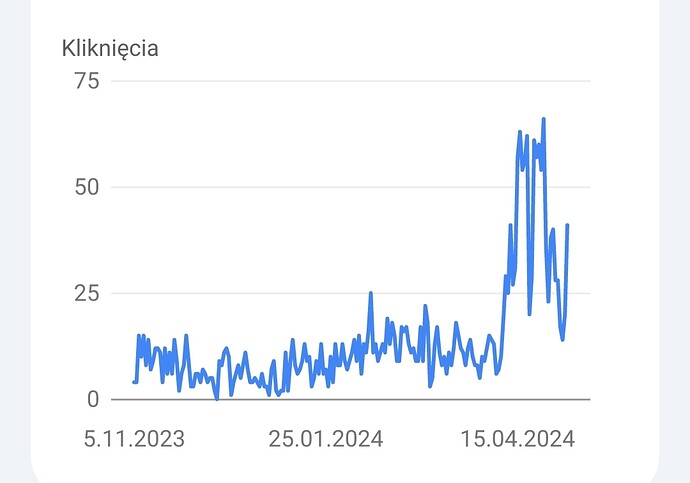
There’s a boost of Google traffic but most is attributable to Poland due to the aed.openstreetmap.org.pl redirect.
Hi ![]()
thanks for the great effort put into this project. I like it.
Since I don’t (wish to) have a git hub account I humbly post here: Is it possible to add an opening hours field with the edit and create tools? I recently discovered some newly added AEDs in my area where people used the location to also add information on the opening hours.
great work, everyone
It’s definitely doable but difficult.
We could provide text field but due to complicated syntax of opening_hours that would be bad UX for new users. We tend to have quite a lot of edits from users editing OSM for the first-time.
We should provide UI which allows to simply input most popular cases: mostly hour range for each day and 24/7.
But still we need to have a option to input opening hours to handle more complicated cases. Such a feature would mostly be used by users already familiar with more advanced tagging
There is definitely need for such a feature so I will analyze UIs available in OSM mobile editors and will think through which one is the best for us
I totally agree with these concerns and can understand that it probably ain’t easy to do while I, as a non coding person, can easily ask for such a feature.
Thank you for considering it and maybe findig a way to implement it ![]()
You should not put too much in OpenAEDMap because mapping an AED is not enough.
The building should also be correctly mapped, with its entrance, possibly with stairs.
We have almost 3000 pictures on Imgur. Should I continue on OpenAEDMap ?
I tried OpenAEDMap in a shopping mall.
I see two insignificant informations, but the level is not there.
It is not mentioned that Location and the image are coming.
And when the image is there after a while, it is not very stable.
I do not see the name of the exit as I do in OsmAnd.
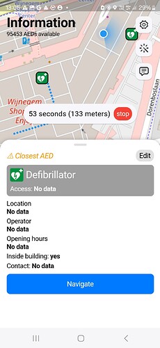
It’s screenshot from mobile app.
I will let the mobile developer know.
Edit: reported in Shopping mall report from OSM community forum · Issue #11 · matisiekpl/aed_map · GitHub
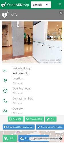
We display level on the website:
I do not see the name of the exit as I do in OsmAnd.
What do you mean? Name of the entrance of the mall?
- https://mapcomplete.org/ has quite a nice (web) UI for
opening_hours; a screenshot is shown here: Troubleshooting problem in MapComplete, wondering if someone can check that these opening_hours are formatted correctly? - #2 by Handsome_And_Mappable - https://every-door.app/ is convenient for adding fine-grained
opening_hours, but might be hard to implement in a web UI.
I give a presentation on AEDs in OSM in Flanders
https://drive.google.com/drive/folders/10szoCsioPbg8CsJ6c9TQx3LXpYMUYoKv?usp=sharing
The Github seems asleep.
I thought it was hosted and supported by a big company, but I see that patrons are still wanted.
Some development is necessary.
I wonder if I still should endorse OpenAEDMap.
That’s true that development stagnated a bit but project is still alive ![]() .
.
There was a plan of major UI/UX revamp so I didn’t spend much time on working on smaller incremental changes which might be modified soon.
Our sponsor is hosting servers. We are working on OpenAEDMap in our free time.
If you find any bugs please report them. I will fix them.
We appreciate endorsing and promoting of OpenAEDMap ![]()
Mapillary is the biggest missing feature.
The competition is a real organisation.
What do you mean by “Mapillary”?
Displaying of images for AEDs tagged with mapillary tag?
Nobody has reported need of such a feature.
Please give us the details and we will consider it.
Worldwide 3540 AEDs have mapillary tag, 2553 in Belgium.
OpenAEDMap was created by real organisation: OpenStreetMap Poland Association.
More than 5 people were involved in creating it.
PS Staying Alive is reporting lang="en-US" for this website so auto-translation doesn’t work well.
Have a look at my presentation above.
And maybe in the future
https://wiki.openstreetmap.org/wiki/Panoramax
Multiple pictures is also a necessity.


