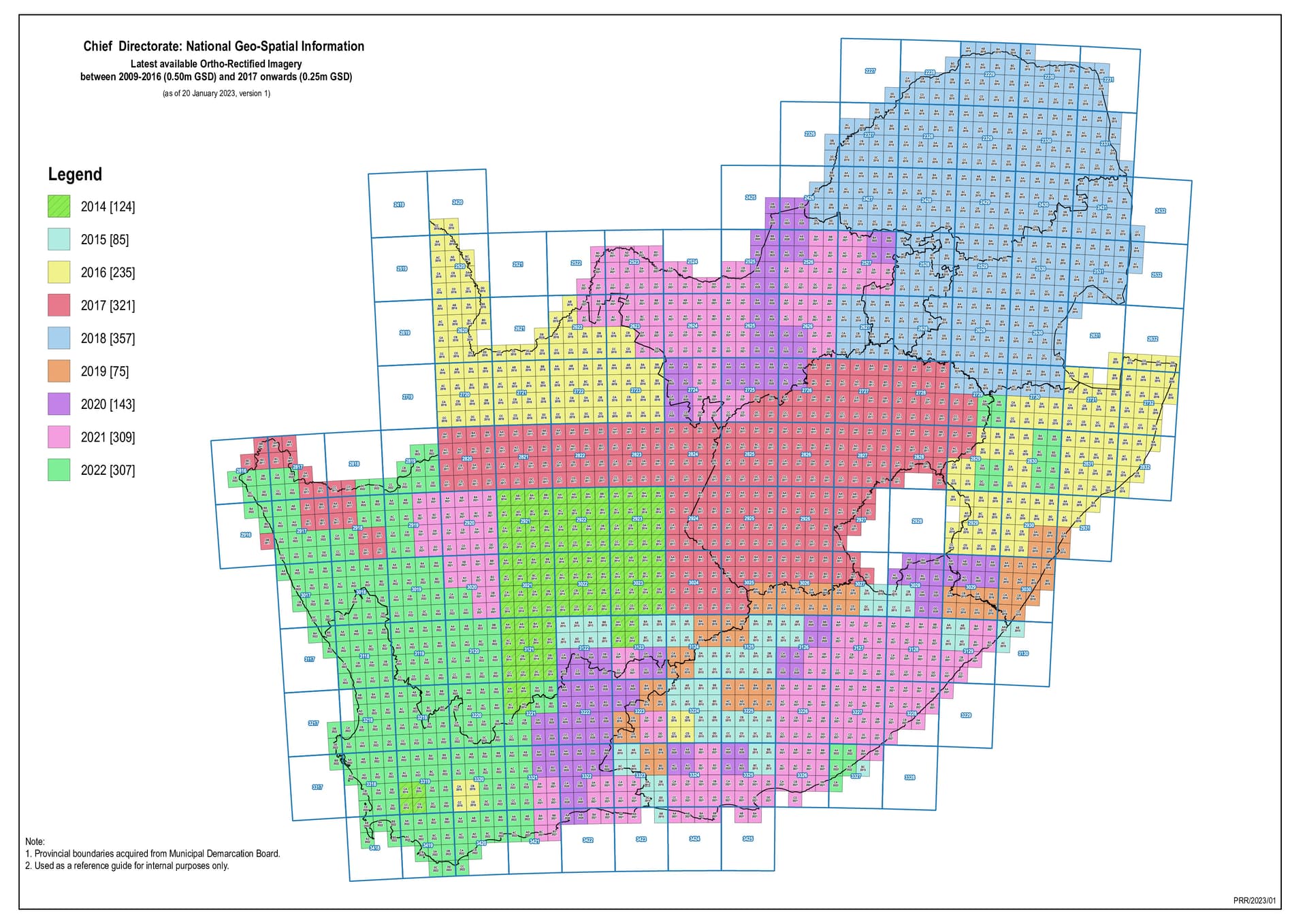
It was recently announced on the OSGeo Africa mailing list that CD:NGI is hoping to have complete 25cm Ground Sample Distance (GSD) Ortho-Rectified aerial imagery coverage of South Africa by the end of March 2023.
The 25cm Imagery is 12TB and is made up of around 45000 GeoTIFF 280MB files.
The imagery will likely need to be reprojected to Web Mercator projection, tiled and overviews generated to be usable in JOSM, iD and other OpenStreetMap editors.
At the moment we are not sure where the imagery will be processed and what will be used for the final hosting. The OpenStreetMap Foundation do have a Dev server, but this “only” has 14TB of available storage.
CD:NGI normally provide the imagery for free. To collect the imagery one provides the “sales” desk @ NGI in Cape Town with an external hard disk and they copy across the imagery over a few days. CD:NGI have the option of charging time and materials, but this has been wavered for us in the past.
We at SAEON have some plans for the WC 25cm imagery that will involve a similar workflow (cogs and titiler). We have an existing server that accepts http range requests we use to host and share cogs. I also have some project funds that could cover the costs of adding additional disk space to the server.
This type of service is probably within the scope of our mandate (we are publicly funded), so I should be able to get this approved.
I would probably need help fetching the data from NGI. It would be a schlep to do it all myself.
Otherwise B or C would work. B might be smarter as we can do the compute on the same rack as the storage.
I would also consider creating a stac catalog of all the cogs. Having both titiler and a stac api that points to the cogs would be the best situation to make the data widely accessible. We could perhaps also host these services.
Let me send some emails to our infrastructure team. If they are amenable we can talk next steps.
Estimated hosting costs on AWS (without any cost optimisation) is around US$500/month. AWS is unlikely to be a route unless we can get sponsored under the AWS Open Data Program.
I’ve also spoken to OpenAerialMap, they don’t think they have the resources (sponsored) to handle the size of the imagery. Not a firm no, but a strong unlikely.
The infrastructure team at SAEON is happy with this and we have the disk space available, it is just a matter of provisioning it. We can also run the HTTP server to share the cogs and titiler service. I can work on creating a stac catalog and eventually get a stac api running too.
We’ve not yet been able to collect a copy of the source imagery files from NGI. Logistics of people taking time off work to get there.
The source imagery will then likely be uploaded to OpenStreetMap dev server. Estimate is likely 2 or 3 weeks to upload the imagery, but maybe copies could be sneakernet shared with others in Cape Town to allow faster parallel upload (bittorrent?).
Once we have a copy of the imagery on OpenStreetMap dev server, I and likely @Adrian_Frith (and others?) will try different COG options. The LINZ example looks like a good starting point to me. Likely take at few weeks to convert the imagery to COG.
The OpenStreetMap dev server does not have sufficient space to store a full copy of the converted imagery. I may be able to find additional temporary storage.
Once all the imagery is in COG format then happy to share with you via whatever works. RSYNC? Bittorrent?
This is great. I would be happy to be part of the sneakernet. I would also like to play with optimising the creation of the COGs.
Once we get around to uploading the COGs to SAEON, we will give you access to the host machine and you will need to connect with our VPN. Rsync will work, not sure about BitTorrent
Let know when the data gathering will commence, and which tiles I should grab. You can reach me at:
glenn at saeon dot ac dot za
too if needed
One open question that I need answered regards CD:NGIs policy on data resharing. Are they happy for us to redistribute their data? I can’t find any info about the licence they use
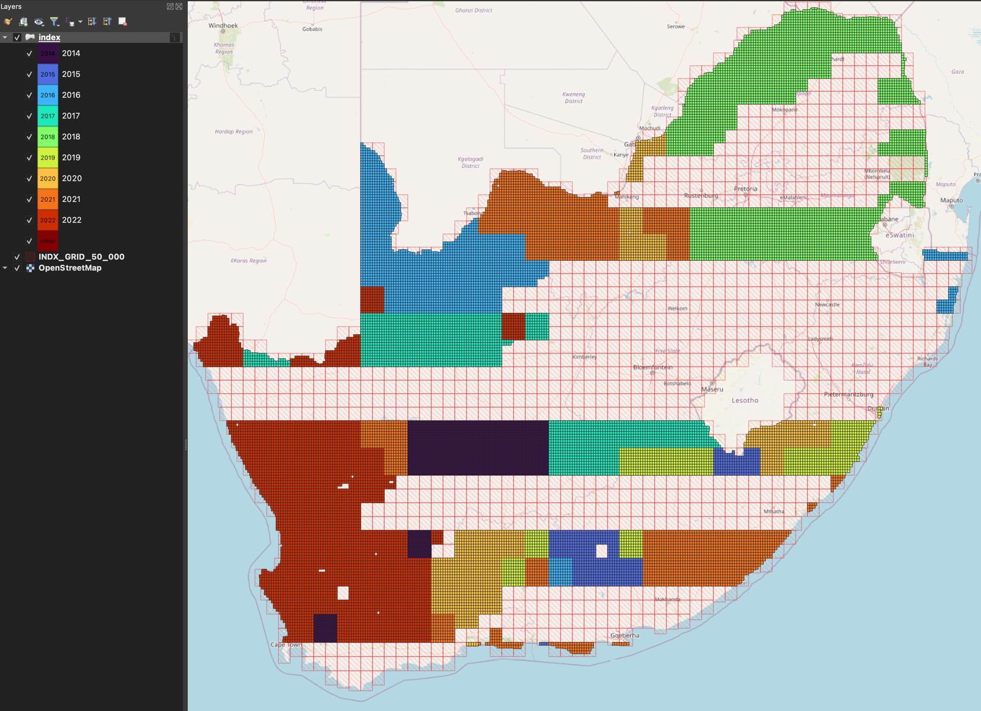
Preview of the imagery is now available here: http://goldbox.firefishy.com:8080/
The preview site is slow and will be much faster for final version. The high zoom level quality will likely improve too.
Additional imagery will be collected from NGI next week.