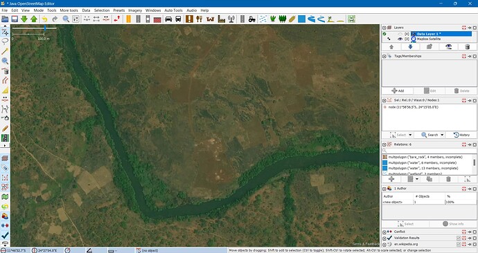
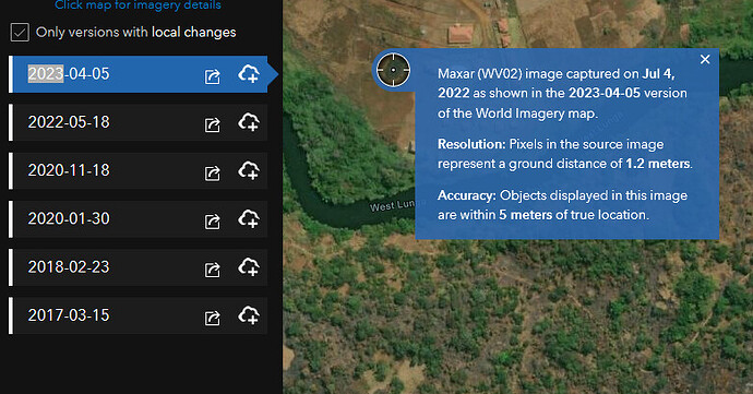
With reference to the earlier images from Bing (Maxar imagery not working (was "Maxar is blurred in ID" and other similar topics) - #41 by ftcat), while not as clear, Mapbox at least shows the earthworks and access road for the development that appeared in Maxar and was mapped. It will be a major blow to mapping in developing countries particularly where HOT projects may be mapping out of date features or where other project mappers, such as those with Apple and Tom Tom who occasionally pass through, change or delete features based on out of date imagery. I have experienced this myself where a mapper mapping for Apple deleted an entire road network I had added from GPS data.
Could you tell us, or suggest Mapbox to implement, if possible, a method to devise/indicate how old the imagery is?
I usually try to compare various sources (bing, esri, maxar [used to], mapbox) and try to figure out who has the newest (and least distorted) source.
Most providers use a timestamped attribution, which is more, or usually less indicate the age of the imagery, and it is clearly visible in JOSM (and elsewhere). Mapbox source do not seem to have an attribution and there is no date of image either.
In my experience Mapbox imagery usually overlaps with Bing, and often have less “visual” resolution, either by having really lower resolution or using a blur/sharpen combo resulting less visually sharp imagery to draw from.
(It may be also useful (and possibly proper for attribution) to know what the image source was, which may be related to its quality. But this may depend on the license details Mapbox has.)
As a slightly unrelated note I wonder what amount of abuse Mapbox see related to OSM keys?
I have just done a quick comparison of BIng, Mapbox and Esri World Imagery over parts of Lusaka. Around the peripheries of Lusaka it is quite easy to see the differences as new developments appear or disappear as you move between the imagery. Within the centre of the city it is not so easy as there is less new development but what development there has been is easier to date. Generally Esri is more up to date than either of the other 2 with Mapbox being the most out of date by many years. A check on tile info with Bing gives a range of 1/9/2018 to 9/25/2021 for metadata capture, I presume this means the imagery can be out of date by up to 5 years. One way of getting a fairly accurate date on the Bing imagery is to look at a newly constructed flyover along the Great East Road, there have been a number of them but 1 in particular was officially opened just before elections in August 2021 and this appears in the Bing and Esri imagery open and in use, in Mapbox imagery only very early earthworks on one end of the flyover is shown. Further along the Great East Road there is a large new conference centre that was opened last year, this appears complete in the Esri imagery and partially complete in the Bing imagery and does not appear at all in the Mapbox imagery. I have seen similar differences in the outskirts of Lusaka but the Esri imagery is not as clear in these areas.
Over more remote areas, such as the development near Mwinilunga I previously highlighted in earlier posts Esri is the most up to date next is Mapbox and Bing metadata capture date is given as 5/19/2012-6/18/2014.
Thanks for the link. While it is interesting to see the changes in Lusaka it is also very depressing to see the deforestation over time in other parts of Zambia.
left click shows
some other places have local imagery made by the government (yearly), because they give them as open data, showing depends on the zoomlevel.
What a pity. It was a GREAT ressource. By pure luck I JUST happened to finish identifying and positioning all buildings in North East Greenland National Park late june. Could not have pinpointed a single one without.
Riverbeds were next to go. Now a no-go…
As you can see above Esri World Imagery use Maxar too, so in lot of places it is the same as Maxar own service. Esri try to get the best imagery possible on a location. All kind of sources.
Have a look at Esri World Imagery.
It’s of course good practice to have from time to time a look at all available image sources.
But nevertheless Maxar was in some regions the most recent source by several years.
Look here: Only Maxar Premium allowed me to map everything including grave monuments here: OpenStreetMap
The same is true for some 300 other cabins, huts, and ruins of such…
Or what about this airstrip? OpenStreetMap The navigation aids are single white painted drums. Easily seen on Maxar Premium…
The mapped area is this Northeast Greenland National Park - Wikipedia
You have a point … it is not Premium detail.
![]()
But fully agree with your post. This clearly shows the added value of an organisation like the OSMF.
For me Maxar was my one and only imagery source . Sad to see it go.
It was high resolution, more recent with barely any offsets unlike the other providers.
We hope Maxar imagery to back, if it requires a license fee, we can have a crowdfunding that funds delicated to pay this fee, and cost of other expense of osm operation of excess the necessary for license fee.
I guess it would be a few magnitudes more expensive as you would guess. That’s not the right direction for a nonprofit project.
So, putting these pieces together a bit, and spurred a bit by @grin’s other thread on this topic, I was thinking of a similar solution to what Minh outlined earlier today. A simple reverse proxy, managed by the community, that the editors use OSM credentials to authenticate against, and the proxy requests the imagery using the API key that it keeps to iteself. It then sets rate limits per user, per zoom level, and these can be adaptive (similar to some of the changeset discussions), based on various account metrics, including age. Registration could be automatic, or separate, with a captcha or something to make abuse a bit harder.
But that all assumes that, from the story above, the only reason Maxar cut off imagery access was because of abuse. If we stood up a reasonable prevention against abuse and prevented any sharing of their API key, would we get access back?
I’d be happy to put some development time into something like this and potentially hosting the gateway service, especially if we can get a small group together. But I don’t want to do it without at least some reasonable assurance that it’d result in them providing access again. Who can go about brokering something like that?
Indeed that was the main suggestion:
- people get individual access to the imagery, using their OSM account (by getting access to a proxy, or getting live Maxar keys, at their option),
- abusers can be disabled individually instead of disabling everyone, and
- new permissions may have various prerequisites, including edit history, account age, community trust score, whatever, to prevent new accounts to be used as repeated abuse points. Basically if someone is disabled, then they stay disabled for a period of time possibly depending on the kind and magnitude of the abuse.
A possible problem, or at least a question will be how to actually determine whether an access is abuse or not, but the mentioned rate limits (based on normal paremeters of real life editing) may work well.
Another way is that we get individual keys from Maxar (which we assign to individuals, possibly with time limited automated rotation if they are actual live keys) so they also can verify/check abusive traffic as well as disable them individually by their taste. That depends on whether they want to do its management themselves or rather delegate it to OSM(F); I think we can accept any of them.
(This way we can also handle key handovers and stolen keys, since they are all connected to a specific individual, who can be disabled for good.)
![]()
I would point my virtual fingers at the OSMF Board.
@Spatialia @grin quite good ideas, but let me give you a little insight in what has already happened behind the scenes on the “OSMF+friends” side of things: A group consisting of some OSMF board members, some people from HOT and myself have worked together back in June/July and actively suggested to Maxar to get such a solution in place (or, in fact, any other solution which would be acceptable by both Maxar and OSM). This even resulted in one person spontaneously flying to a conference to talk in person about this very idea with a Maxar representative. Unfortunately, our efforts had not been fruitful at the time.
OK, thanks for the update @tyr_asd. I appreciate the effort you all put in to find a resolution. It sounds like there are bigger issues at play than just authentication then and a community project can’t resolve this.

