Mapping old Korea/옛 한국 지도 만들기

Hi everyone,

I’d like to do some mapping in OpenHistoricalMap (OHM) based on old maps of Korea.

I’m focus a lot on North Korea in normal times, but for this project I would also like to look at South Korea. And I would map, why not, old big cities like Seoul/Busan/Daegu?

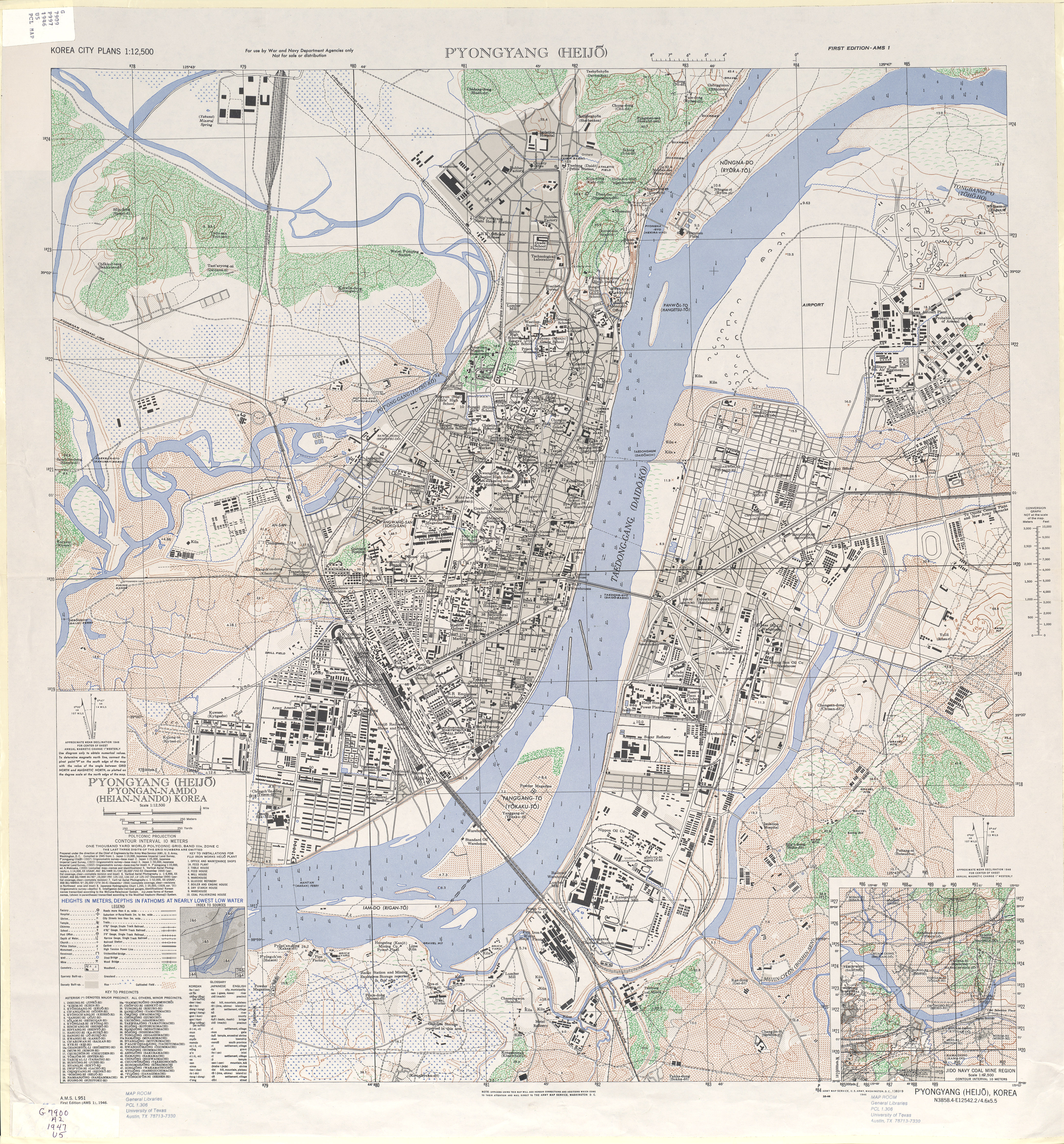
Do you have any sources of old high-resolution maps of Korea, particularly Seoul and Pyongyang and the country’s other major cities between 1880 and 1950?

At the moment I have

But the maps on maps.lib.utexas.edu are very often American, from the 1940s-1950s.

Are Korean (and Japanese…) maps available for the years 1880 to 1950?

Thanks a lot for your help :slight_smile: !


안녕하세요 여러분,

한국의 옛 지도를 기반으로 오픈히스토리맵(OHM)에서 매핑을 해보고 싶습니다.

평상시에는 북한에 많이 집중하고 있지만, 이번 프로젝트에서는 남한도 살펴보고 싶습니다. 서울/부산/대구 같은 대도시를 지도화해보고 싶어요!

1880년에서 1950년 사이의 서울과 평양, 그리고 한국의 다른 주요 도시를 포함한 한국의 오래된 고해상도 지도를 구할 수 있나요?

현재 나는 가지고있다

하지만 maps.lib.utexas.edu에 있는 지도는 1940~1950년대의 미국 지도인 경우가 많습니다.

1880년부터 1950년까지의 한국(및 일본…) 지도를 구할 수 있나요?

도와주셔서 감사합니다 :slight_smile: !

(Hangeul translation made with Deepl)

3 Likes

Thank you for your interest in the ancient geography of Korea.
First, let me link to the material I have.
South Korean government agencies are not very friendly to foreigners, let alone their own citizens, when it comes to opening up information.
If you’re not familiar with the Korean language, it can be very frustrating.


If you experience any difficulties, please let me know.
If I find more, I’ll add them.

3 Likes

Old map? What about David Rumsey‘s collection?

https://www.davidrumsey.com/luna/servlet/view/search/where/Korea?q=world_area%3D"asia"+LIMIT%3ARUMSEY~8~1&sort=pub_list_no_initialsort%2Cpub_date%2Cpub_list_no%2Cseries_no

Here are all maps contain Korea (and neighbour countries)

2 Likes

The problem is that I can’t map objects like roads, buildings and landuse with this map because the scale is too large, unfortunately.

1 Like

As you probably know from your understanding of Korea, modern surveying technology was brought over from the West when the Japanese imperial state began invading and stealing, so proper Western-style maps didn’t come into being until the mid-to-late colonial period.
It’s probably not easy to get hold of good ones, but I’ve added a few more that are readily available.

1 Like

I asked the OSM JP community on Slack and got some replies, so I’m posting it here as a post-it.

nyampire_Satoshi :

I found several research references mainly to paper maps here.
https://rnavi.ndl.go.jp/jp/maps/theme_asia_48.html

3rd clause refers “digital resources” (インターネット情報源) and it includes 帝国陸軍陸地測量部’s (The Map division in the Imperial army,) military map.
That is 1/50000 scale.
Seoul library has the original.
https://db.history.go.kr/item/level.do?sort=levelId&dir=ASC&start=1&limit=20&page=1&pre_page=1&setId=-1&totalCount=0&prevPage=0&prevLimit=&itemId=jnm&types=&synonym=off&chinessChar=on&brokerPagingInfo=&levelId=jnm_013&position=-1

The pain is that the map is not geo-referenced.
So it is better to use Mapwarper to locate it.

mzaki :

Center for GIS, RCHSS, Academia Sinica (Taiwan) provides nice UI for the 1:50,000 military map (you can overlay them on OSM!).
http://gissrv4.sinica.edu.tw/gis/seoul.aspx

  1. drag the map to the place of your interest (e.g. Pyongyang)
  2. open 図階 menu from the lower left corner
  3. select 日治時期北朝鮮五萬分一地形圖 layer
3 Likes

안녕하세요. OHM 유저 Hangukhistory라고 합니다.
(영어가 짧아 부득이하게 한국어로 남깁니다)

서울 한정으로 말씀드리자면,
서울역사박물관에서 제공하는 '서울역사아카이브’의 ‘서울지도’ 서비스가 있습니다.

1900년대부터 1970년대까지의 다양한 근현대 지도를 제공하며,
공공누리 제1유형 (KOGL Type 1)으로 배포되어 저작권도 자유롭습니다.

Wikimedia Commons의 Maps of Seoul 카테고리에도
해당 서비스의 자료를 가져와 몇몇 지도가 올라와 있는데
Wikimaps Warper를 경유해 매핑하시면 될 것 같습니다.

부산 평양 등의 지방도시 근현대 지도는 저도 찾고 있는데
웹에 자유롭게 공개된 지도 서비스가 거의 없어서 매핑하지 못하고 있네요.
그밖의 서비스는 깨몽님께서 잘 설명해주신 것 같습니다.