Partiamo con il dire che la valle Po esiste (per chi non è della zona) ed è una piccola valle montana in cui scorre il Po ![]() . Anche per questo all’inizio la linea in questione mi era parsa insensata. Poi ho capito che siccome gli inglesi chiamano “valle” la pianura (
. Anche per questo all’inizio la linea in questione mi era parsa insensata. Poi ho capito che siccome gli inglesi chiamano “valle” la pianura ( ![]() ) (wordreference conferma) quello era solo un problema di toponomastica.
) (wordreference conferma) quello era solo un problema di toponomastica.
Detto questo resta il problema della Pianura Padana. Una veloce ricerca confermerebbe che non esiste, tutti sanno che c’è ma nessuno sa bene dove sia. Questo lo spiega abbastanza bene anche questo articolo https://www.greenlifeblog.it/2020/10/10/pianura-padana-pianura-padano-veneta-o-val-padana/. Nei miei ricordi di scuola (quindi assai vecchi) la Pianura Padana cominciava a Torino e si estendeva ad est, quella a sud era altra cosa. Anche perchè le due pianure sono collegate da un passaggio largo circa 14 km a Torino, poca cosa considerando le loro dimensioni
Mi accingevo a suggerire una correzione, che più o meno o poi visto coincideva (forse) con l’idea originale. Se si volesse accettare come ipotesi che la pianura padana è l’area che si raggiunge, partendo dalla foce del fiume Po, mantenendo la pendenza al di sotto di un valore stabilito, quest’area potrebbe essere trovata con facilità ed essere anche verificabile. L’ipotesi mia era di prendere un DEM a 30 metri (volendo si potrebbe anche provare con quello a 90 m) e buttarlo in Qgis elaborare le pendenze, selezionare quelle sotto il valore stabilito e poi rasterizzare il tutto. A questo punto c’è un riferimento georeferenziato da usare su cui poi fare le piccole correzioni locali.
In ogni caso resterebbe il problema di quale pendenza usare. Prove si possono fare per vedere i risultati…
… oppure eliminiamo dalla mappa l’idea di andare a definire dei confini che nessun altro a mai tracciato ![]()
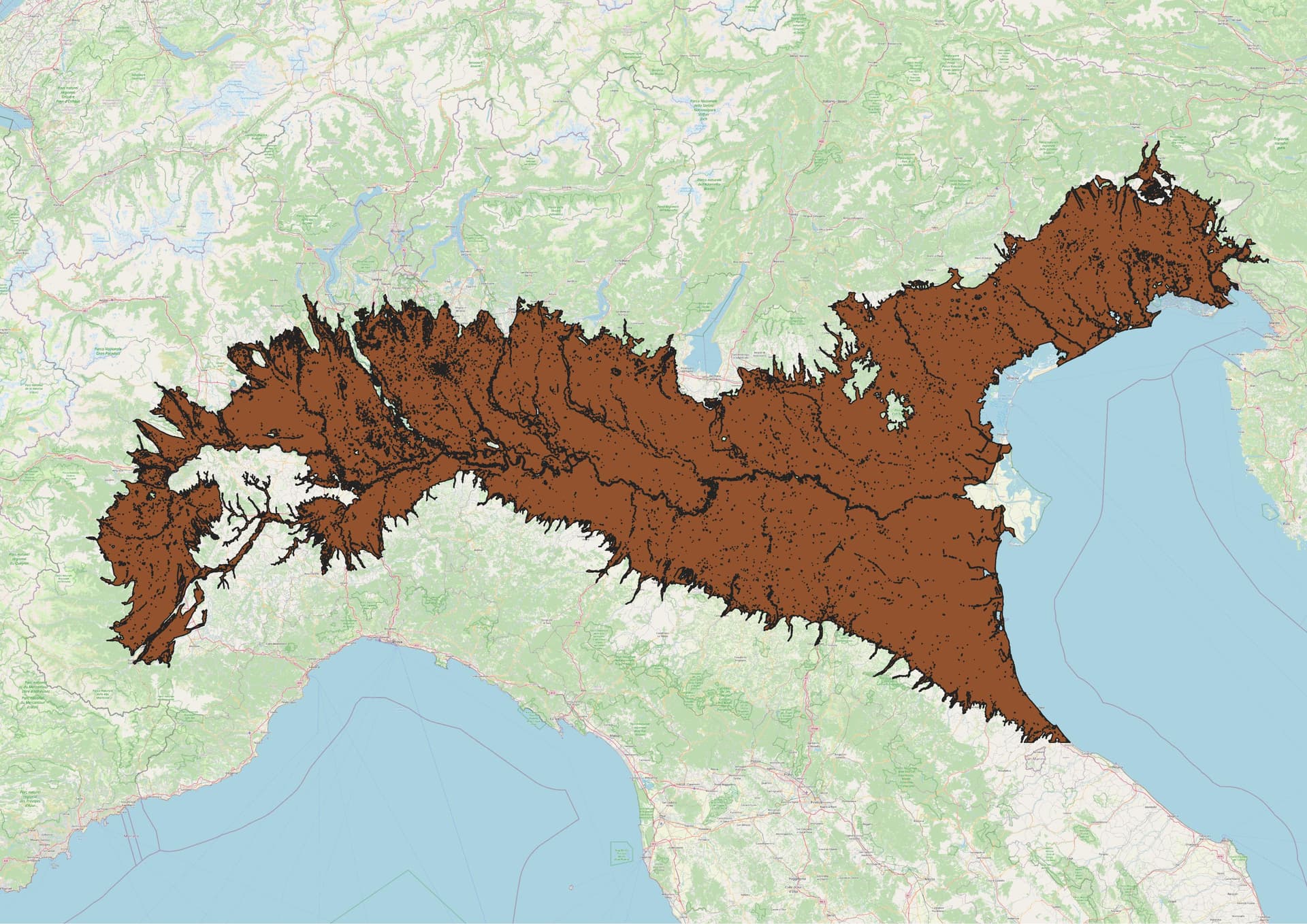
Tanto per giocare ho cercato il DEM ed ho trovato direttamente il file con le pendenze sul sito del progetto Copernicus, così ho risparmiato finanche 3 click ![]()
Non ho trovato ne mi sono preoccupato del copyright dei dati, tanto era una prova e comunque il risultato si può ottenere partendo da dati open.
Le pendenze sono in un range da 0 a 250 dove 0 è verticale e 250 praticamente piano, la scala non è lineare. Comunque io ho preso solo il valore 250, l’ho buttato su un layer con OSM e gli ho dato una trasparenza adeguata. Quello sotto il risultato.
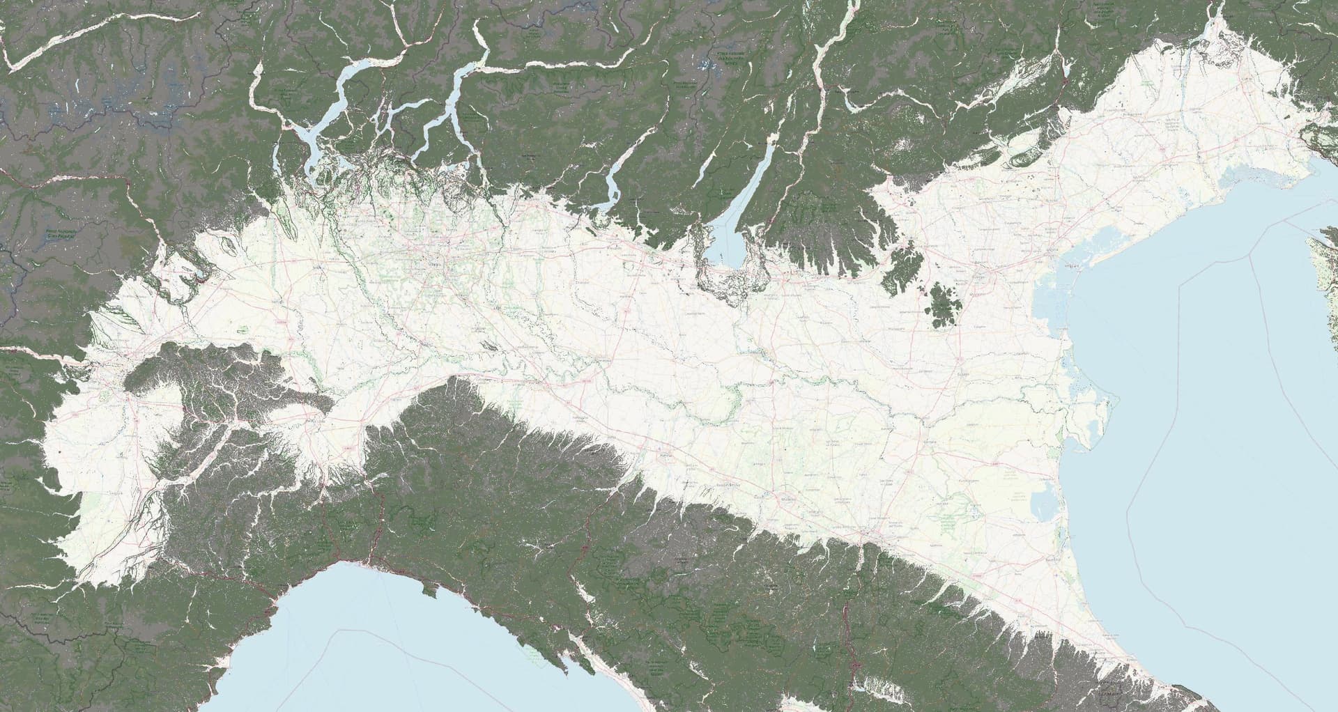
Dopo di che si deve mettere manina e correggere localmente il tutto.
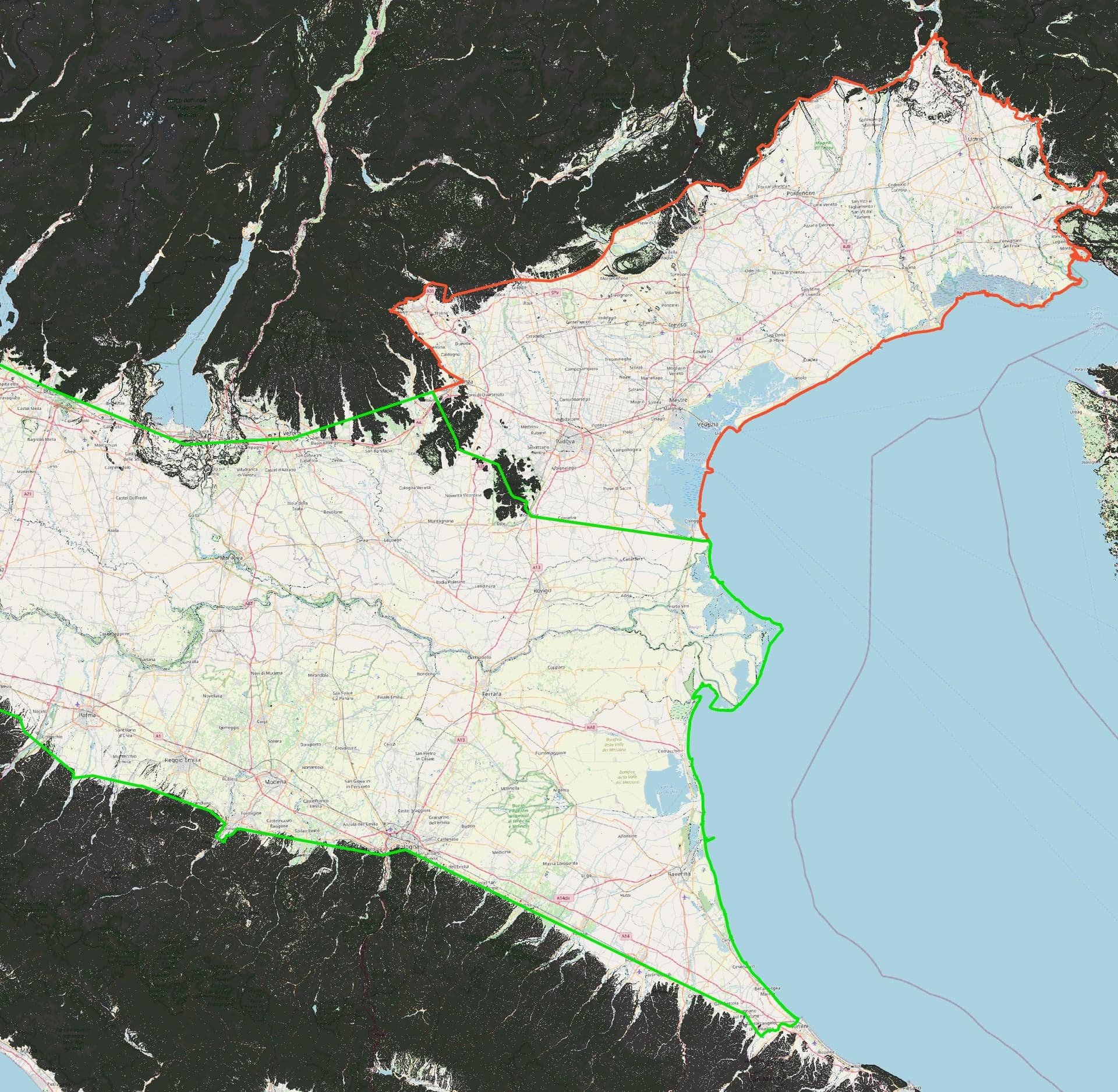
Can you add also relations of Pianura Padana 11744240 and of Pianura veneto-friulana 11752082, just to see differences on edge?
I will try. Need to try to export relations fron OSM. Give me a couples of days
Part of the problem of this type of elements is that in OSM is not possible use Spline and it is necessary use many points to follow some border line.
detailed 1
detailed 2
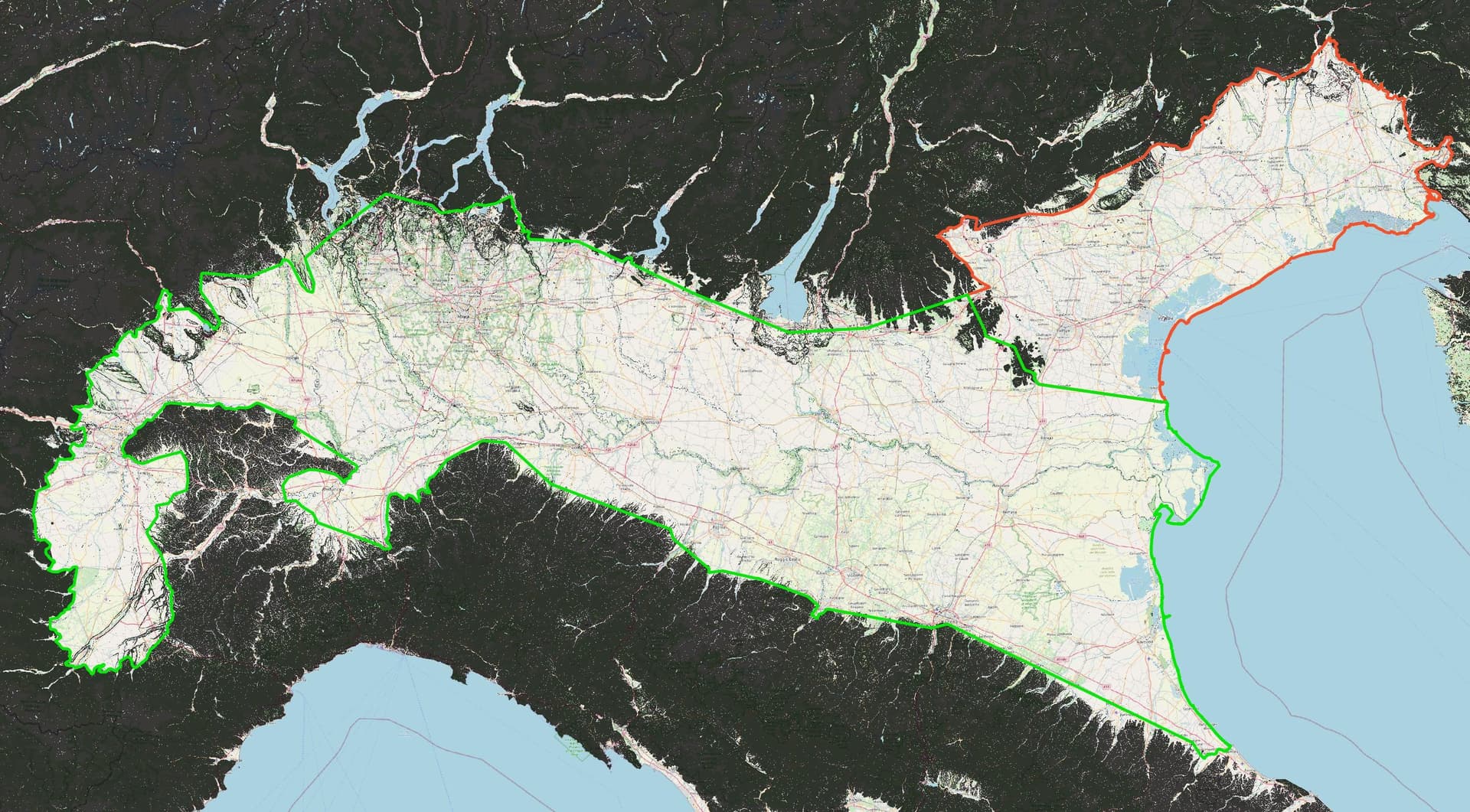
the shore line has been followed very well, but from Bologna to sea it is too much coarse (ever IMHO
One more point.
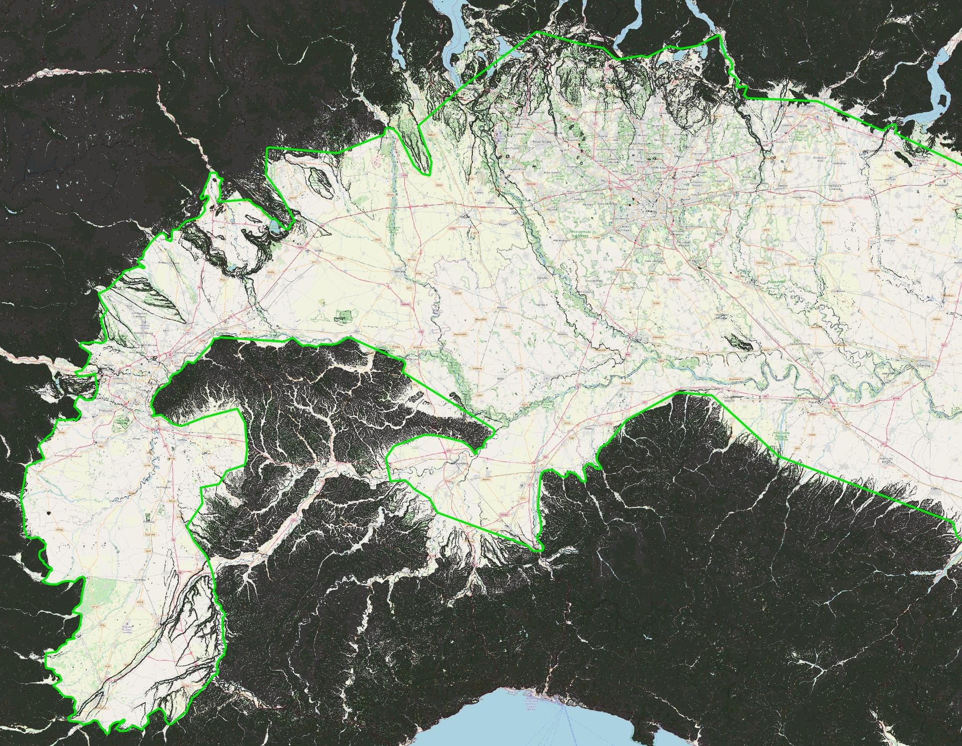
Another example of problematic point is the altipiano di Ivrea (Serra morenica di Ivrea). From maps, satellite view or gis is quite hard to understand if it is part or not of the pianura padana, just who know the area can fix properly the question. This is the reason because I wrote:
localmente=locally
@Mauromago, thank you for your contribution!
If you check how OSM started … we’d ask “what is detail? at that time” ![]() now we have very delailed map. Pianura padana (I believe “Padan plain”, not “Po valley”, would be proper english name) is huge area (it should not be mapped with one line only) so mapping started with few points and will continue trimming with more details. It meets with Alp’s area on north (somebody already mapped this - it was similar started as non-detailed mapped area) and will (I believe) meet with Appenini area on south some day.
now we have very delailed map. Pianura padana (I believe “Padan plain”, not “Po valley”, would be proper english name) is huge area (it should not be mapped with one line only) so mapping started with few points and will continue trimming with more details. It meets with Alp’s area on north (somebody already mapped this - it was similar started as non-detailed mapped area) and will (I believe) meet with Appenini area on south some day.
Pianura padana is not ment to cover valleys. They meet padanas but are not part of them (like Vipava valley meet “Pianura veneto-friulana” but is not part of).
It should be finished with coast line (not administrative or similar non-natural tagged line) on the sea side.
This part/area between Torino and Alessandria (and Asti) is still/already Appennini?
p.s. sorry for not being confident to write this in italian. Covid stopped my italian courses and now some other priorities before continueing.
I have no question on how elements born and gain details. My original problem was with a line I found in my area and I was not able to understand what it was. (by the way, why boundary is not jointed all together?) Once I understood its nature things become more clear. I go ahead in order to push local mapper to improve it. It is also true what AnyFile wrote, note sure a “not existing area” is properly placed on OSM, But this is a philosophical question ![]()
About Hill from Turin to Alessandria, no they are not Appennini. These hills are named with different name place by place, no a unique name.
p.s. My English is not as good as I should like too ![]()
p.s. 2 I will try to create a shp file with boundary starting from free data and place it here to help who will help to fix it.
Alps (2698607) use same line on the north of . We wish to continue with Appenini (all together, and later adding parts inside) on the south.
Administrative boundary does not follow naturals and are affected of history and politics.
In Mondovì area Alps need to be corrected too, IMHO.
Citazione Alps (2698607) use same line on the north of .
That is not right. In Piedmont (so called for this reasons) Alps start from plan (Piedmont= at the foot of the mountains) but for the other area, before Alps there are the Prealps, some lower mountains that is not properly part of the Alps themself. Also for this question, as for Pianura Padana, is not easy to find sure sources and univocal idea. Maybe in this situation the best references could be (old) first level school books. ![]() Easy and old… best way.
Easy and old… best way.
(suggerisco di cambiare il titolo con qualcosa di piu’ adatto al contenuto attuale, qualcosa sulla falsariga di “Mappatura Pianura Padana” così è meglio indicizzabile da chi scorre i topic della categoria Italia)
I understand your concern, but as I’m aware there is classification that put Prealps in.
- On the west, there is stil used “Partizione delle Alpi” or I don’t know newer/better accepted classification.
- On the east we’re more familiar with “Alpine Club classification of the Eastern Alps” (list)
- however there is also SOIUSA proposel.
From my point of view, in all classifications alps end with Pianura padana / Po plain.
Perhaps I am too fond of what I learned in school as a child. Confusing Alps and Pre-Alps was wrong.
However, it seems clear to me that the problem here is again to understand well what we are talking about. In fact if we are talking about geological Mountain System, namely a mountain range, then the Alpine System is certainly composed of Alps and Pre-Alps, but if here I say to friends, “let’s go on a trip to the Alps,” they certainly expect us to go to the “Alps” (the real ones). ![]()
Interesting that image on wiki exclude Torino or put it on west border.
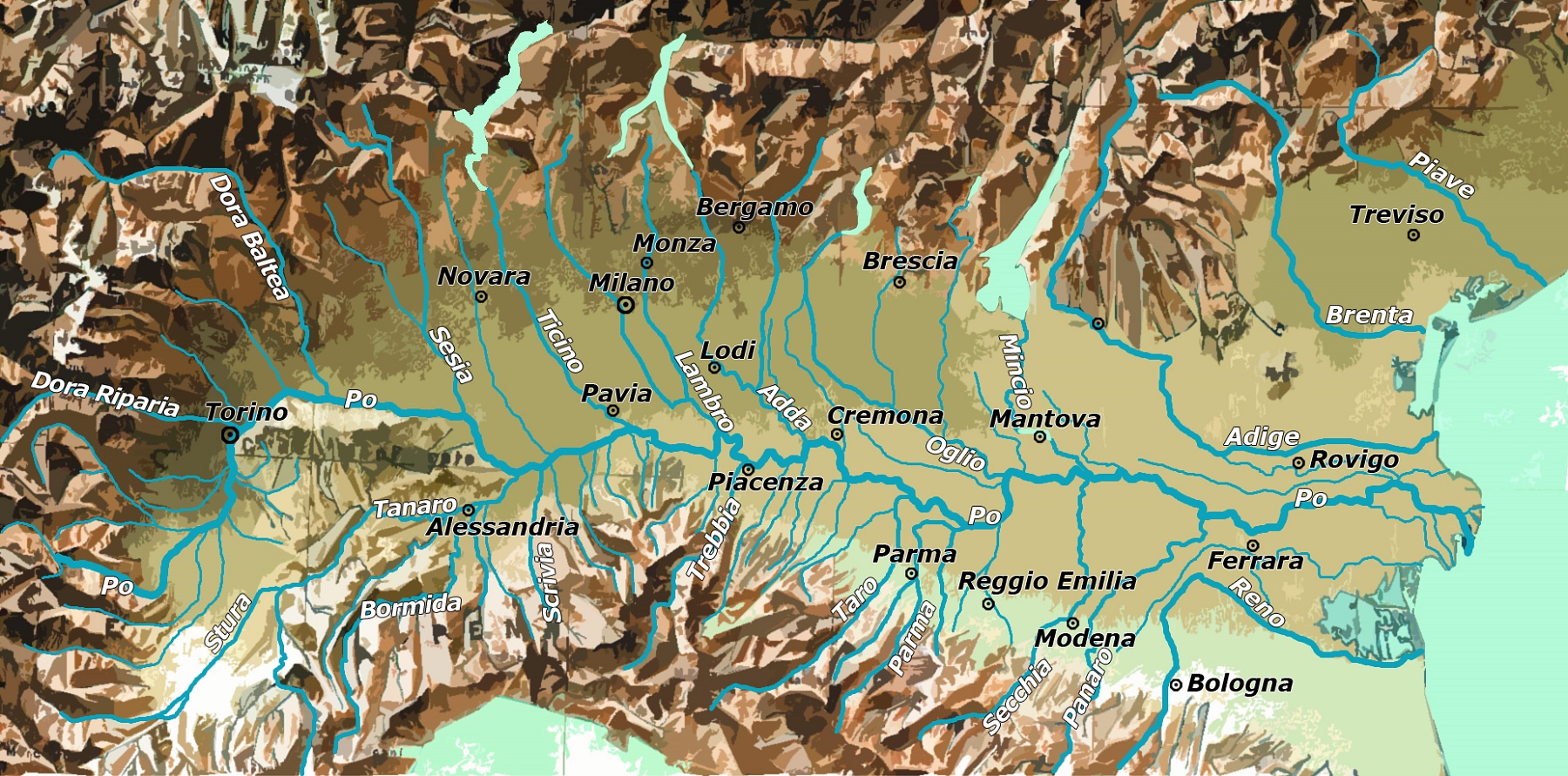
Immagine dal satellitedell’Italia settentrionale: la Pianura Padana è la zona verde (in falsi colori), all’interno dell’ovale rosso, estendentesi nella pianura veneto-friulana a est.
The more that I study Po plane the more seems to me that Tanaro should be south border of plane with Apennini on other side. Yes, it may be seen as ignoran job, but I believe that locals will correct me in a sense “more heads more knowledge”.
I like this presentation.
I also need to confirm, that in english was made big confusion with Valle Po. I’m asking my self why not using “Po plane” name.
Tanaro divide Langhe from Roero, laft side Roero right side Langhe. Langhe for sure is NOT part of appennini. Thousands of winegrowers would rise up if this were written ![]()
Langhe are divided in bassa Langa and alta Langa. (Langhe is some time named as plural and some time as singular, old question never fixed)
Langhe and Roero border Monferrato to the southeast and the hills of Turin to the northwest.
Langhe (alta Langa) and Monferrato border with Appenini.
About the name in English for Pianura Padana I think that question should be fixed by natural English speaker, I will continue to name it in Italian ![]()
Looks me that the link to image you refer at the beginning is wrong or missing, or at the least I not able to find it
Found an image looking on google for the exact frase cited. https://it.wikipedia.org/wiki/Pianura_Padana#/media/File:Pia_padana.jpg That is what we studied at school many many years ago ![]()
Forgot. The Monferrato is also divided in basso and alto, basso is sometime divided in casalese and astigiano. Alto Monferrato border with Appennino.
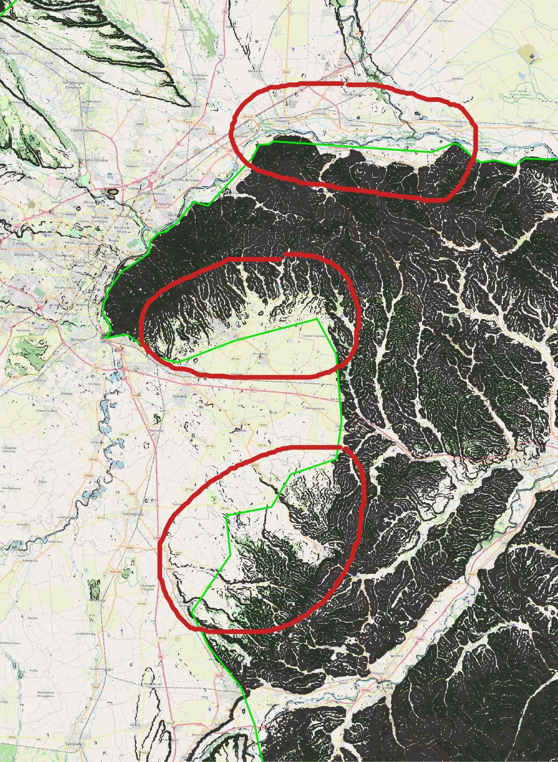
I found super relation that I was searching for - Relation: Eastern Alps by Alpine Club classification (2113486) which effects on Pianura Padana.
I also find some SOIUSA classification areas that (should) meet Pianura Padana. Those areas does not have superroute so it’s harder to get all areas under this SOIUSA criteria.
This is al about north part.
I found the license of dataset used to produce the Pianura Padana area, it looks be OK for use here and it is necessary the citation:
Dataset Citation: European Space Agency, Sinergise (2021). Copernicus Global Digital Elevation Model. Distributed by OpenTopography. OpenTopography - Copernicus Global Digital Elevation Models. Accessed: 2023-04-17
I used 90 m dem, using already calculated slope. I selected area with 2° or less of slope. 90 m is better IMHO for this type of work since the results are less detailed.
Some areas at shore are not included, but this is effect of data execration done by me too quickly.
Data are available in shp format and more simplified directly in osm format
There is any place where is preferred to put them? Looks me it is not possible to attach them at message here.
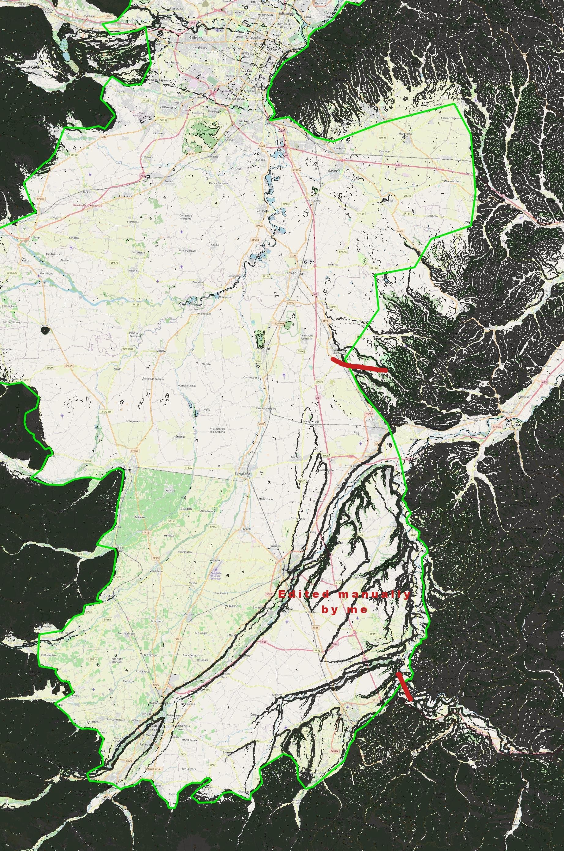
Please note that manual correction is ever necessary
I edited the line from Volpiano to Trino, Now this part should be quite OK. I will not do the same in other areas since it is possible to do great error if you don’t know the places.
If someone want to do it I can give him/her a OSM reference file.