Now we’re working on a project to fill the University geographic data on OSM. After making changes we noticed that random people that do not make part of our official administrative members can insert some geographic data that is not correct and this may confuse users of OSM and we can provide proofs about that.
So we’re wondering if it would be possible to give us an admin account and the possibility to be able to modilfy our geographic data on our three campuses : El Bez, El Maabouda and Travaux and forbid any other changes made by random people.
Please feel free to contact us for further information.
I have replied to this question a week ago in
https://www.openstreetmap.org/changeset/148767034 :
OpenStreetMap is a collaborative project in which everyone is welcome to
record the reality on the ground; the university does not get to control
what is (or is not) mapped on the university campus. There might, for
example, be an “unofficial” path used by students but the university
leadership does not want students to use it - nevertheless the path
exists an can be recorded in OSM. The people who make these edits are
not “random people”, they are OSM mappers and they have 100% the same
rights as your staff members have. OSM is not a tool by which to promote
some “official” view of things; if you want full control over the map
then you need to make a copy of OSM and edit it in a graphics program.
OSM itself is independent of your university.
Hello and a warm welcome to OpenStreetMap, a free and open map data project where anyone can contribute data. It is not possible to block certain areas for “admins” only editing.
If you do not wish that your data is modified by someone else, you must keep and maintain it separately from this project in another database and not ours.
Best regards
mcliquid
As in your other thread, please show us what you’re talking about by adding a link to the OSM map for that area.
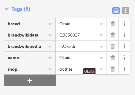
It is certainly possible to change the name in ID editor by going directly to the tag field below the name=* field which shock the lock in the top preset section.
An example with as shop in ID Editor. As can be seen the name field has a lock icon.

But, if you scroll down there’s the direct tagging section with which you can override what the preset filled in…
With such an edit, here suffixing the - Montesilvano to the name
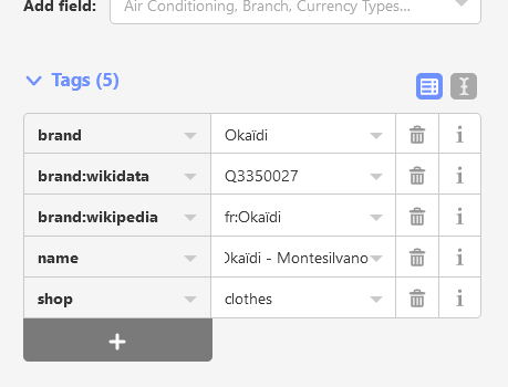
You get the preset area to show that name too, which then comes with alert and bells but you can hit ‘ignore’ to let these go away.

(Think it was mentioned somewhere recently how to do these ID Editor overrides. Since using the JOSM editor, no such warnings, but those app users have a preset plugin (Name Search Index for short NSI) to let these branded fields filled in for the mapper)
Maybe it’s one of these changesets?
- Changeset: 148961375 | OpenStreetMap
- Changeset: 148946747 | OpenStreetMap
- Changeset: 148898229 | OpenStreetMap
- Changeset: 148896887 | OpenStreetMap
Maybe changing this highway from footway to service? Way History: 1264430291 | OpenStreetMap
As the parallel topic makes clear, iD is preventing the editing of a name because a wikidata tag is present.
There are ways around it, of course, but first I think that it makes sense to ask in what way the name is wrong.
Think the Uni admin can always add access=no to those informal unwanted but OSM truther mapped ways… they’ll get a dashed line render on Carto.
Well, thanks a lot to all of you
Best regards
Please,our univercity has 2 branches (univercity ferhat abbes and lbez) I want to give them the same name but the name of univercity ferhat abbes is loked because it has a wikidata tag, how can i change it?
How to change the name=* if it’s “locked” in iD is explained in this post. You can obviously also use another editor. I personally use JOSM and this isn’t an issue there.