Personally, due to large size, and at least large part of them not being bound to road I treated such stones not as gravel paving but as obstacle - and tagged such road as tracktype=grade3/tracktype=grade4.
But as seen for example in this report intepreting such surface as matching “Usually an unpaved track with surface of gravel mixed with a varying amount of sand, silt, and clay.” is also possible.
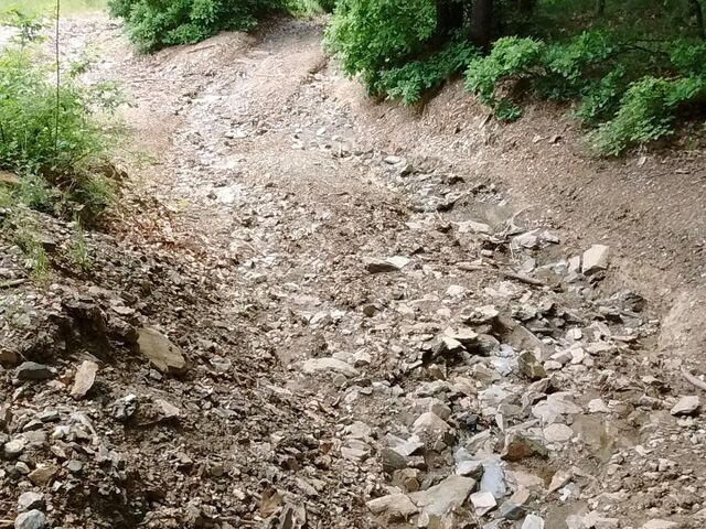
When I started mapping, tracktype=grade2 tracks were tracks with similar properties than a track with a paved surface (similar well cycleable), i.e. smoth compacted, fine surface material. Smoothness wasn’t invented yet, and the meaning of “tracktype” wasn’t well defined. Somehow it is still like this. although there are now more tags for individual properties, tracktype is still an “overall rating” of not so clear properties, with a local / regional scale where the higher grade means “worse” (not necessarily when comparing two tracks on different points of the globe, but locally). This picture shows a very rough trail, rather hard to cycle on. if it is possible at all. It also doesn’t look as if it was much improved to become a track, I’d rather see this as grade3 or 4
Thanks for bringing this up, Mateusz. The photo you posted was made by me and is used on the wiki to illustrate smoothness=horrible.
I have tagged tracks like this one as grade2 because it has many large stones that can carry the weight of even a large truck and distribute it to the solid rock that is just below the surface, so the surface will hardly deform even if the clay in it is wet. I think the firmness of the surface is what track_type is trying to express.
Considering the descriptions of the various unpaved surfaces on the wiki, I believe the surface is not dirt or earth because it has plenty of gravel and rock, is not compacted (just bulldozed), is not gravel or fine gravel because most stones are much larger than track ballast (I tend to use these surfaces only for stones of quite uniform size that have been brought from elsewhere to improve the track surface), is not rock because although there is some bare rock and many large stones, they have not been arranged “to improve path quality” (they are the reason for the horrible smoothness, in fact), is not pebblestone because the stones are not rounded, etc. ground is really the only remaining option apart from unpaved. The surface is as deposited by nature and has never been improved by humans by adding material to the surface; it has only been bulldozed to make it a bit more even (for me, “surface in its natural state, without added materials” is the definition of surface=ground). However, because of the larger stones in it and the solid rock just below it, it has very good firmness.
@dieterdreist We posted almost at the same time… I started mapping much later than you did, so I’m only vaguely aware of the history of the tracktype key. It seems like it started as an attempt to evaluate usability/passibility of tracks, developed to a description of the ratio of hard and soft materials in the surface (which makes it more verifiable but less useful) and now seems to be an estimation of firmness of the surface (how much it changes when wet and when driven on by a heavy vehicle). The last is my interpretation of the wiki text as it is now.
I think that smoothness is now doing a much better job of describing the usability/passibility of not only tracks but also paved ways, and I am wondering why we still waste time on tagging tracks with tracktype…
I agree to @rhhs that tracktype is primarily reflecting the firmness of a track which is in accordance with the description in the wiki. As the track in the picture appears definitely to be very solid and firm I’d also say it is grade 2.
Substance and roughness are attributes better described by “surface” and “smoothness” imho.
Definitely grade 4 to me.
My rule of thumb: I’d drive the family car on grade 1, in 2nd gear on grade 2, very carefully on grade 3, and not at all beyond.
How come? A track of grade 4 with a surface of ground or grass can be perfectly fine to go along with your family car, as long as the smoothness is good, which does not depend on the tracktype classification.
If you have a look at the sample pics in the wiki the tracks with grade 3 and 4 would give you a comfortable ride even with a Cadillac or Mercedes and the grade 5 sample track would still allow to go along with any saloon car in dry weather conditions.
Tracktype grade 4-5 does not tell you anything about the roughness of the surface, but only to be aware that in wet weather condition they may become unpassable due to the softness of the ground.
This got me confused, though. I would mark that as surface=rock because it is mostly rock, and behaves mostly like a rock (you know: if it looks like a duck, and quacks like a duck…)
I don’t see why you think surface=rock should be because it “improves path quality” ? IMHO, surface is a rock because it is rock, not for some “quality” reasons.
Sure, sometimes it might be because someone added the rock for improving quality (often it is tagged as surface=gravel, though), but sometimes it is completely natural. It may even be because someone added rocks intentionally to reduce quality (for example to prevent cars trespassing on their private property as it is nice shortcut).
See e.g. example 4 on that wiki page: “Trail going through exposed rock, surface=rock on highway=path is a proper tagging here” or example 3 “Rock covered trail surface on the Ole Ranger Trail at Patapsco Valley State Park”
Because before smoothness and all, I mapped tracks without grass (in forest, in mountainous areas) and I needed to scale those from 1 to 5 according to the overall quality of the track.
My interpretation of the rock tag is that it is to be used for either
surfaces consisting mostly of exposed bare rock, or of
Big pieces of rock used to improve path quality / some cases of man-made surfaces of trails
(quotes from the surface and rock wiki).
The photo in this post shows an example of a track that has a mixture of many surfaces, with none of them dominating. So instead of tagging it as surface=rock;gravel;fine_gravel;sand;earth, I think it is best to tag it as surface=ground. The example 3 you mention is the most similar, but has a much larger proportion of large stones.
But now we have smoothness as the indicator of road quality…
I think the essential service that a map should offer is that it helps the user decide how to go from A to B in the most efficient way. For this, the user needs to decide which roads to take, and the map should give him information to help in that decision. In order of priority, I think these should be:
Usability of the road: can the user use this road with the vehicle he intends to use, or would it be preferable to take another better road that is longer? smoothness serves this need for route planning.
Recognition of the road: once the user arrives at the road junction, he has to be able to recognise the road he planned to take by comparing it to information that the map is giving. surface serves this need by describing the appearance of the road surface. Thanks to the availability of GPS positioning, this aspect has become less essential.
Risk evaluation that the chosen road may be less usable than since it was last surveyed. tracktype serves this need (as it is now, in my interpretation of the wiki), by giving some information on how the surface of the track might have changed because of wet weather and use by heavy vehicles: how likely is it that because of wet weather, the surface has become so soft that the user’s vehicle might get stuck, or that it has been deformed by heavy vehicle traffic so that ruts have formed and the ground clearance of the user’s vehicle will not be enough to pass without damage? It gives an impression of seasonal variations in smoothness.
The photo in this post shows an example of a track that has a mixture of many surfaces, with none of them dominating. So instead of tagging it as surface=rock;gravel;fine_gravel;sand;earth, I think it is best to tag it as surface=ground. The
+0.5, this is what I think is done most, albeit it is hard to evaluate if you are not aquainted with the area (it can mean earth in some areas and rock in others), so I am not sure if it is recommendable tagging. Clearly it is used orders or magnitude more: https://taginfo.openstreetmap.org/tags/surface=ground (2,8 million)
Thanks, I see where you’re coming from. I’d still probably mark that as surface=rock as it dominates the potential use of path (even if perhaps it does not have the supermajority percentage or surfaces). i.e. if someone were considering whether to use that path, they would likely not worry whether there is some sand and earth, but about those rocks…
There seem to be few hundred uses of surface=bare_rock. It’s not documented on the wiki, though.
Is that typo or not? If not: no, I would not mark surface of highway=path with natural=bare_rock, as that one is documented to applying only to areas, not ways.
If it was a typo, and you meant surface=bare_rock, I would consider it once it is documented on the wiki, and its description matches what I see. But as that one is currently undocumented, I would currently avoid it and choose best matching documented alternative (likely surface=rock).
I concur, the amount of loose material is just too much. A grade2 has to have at least a flat/crowned surface.
Maybe you have local knowledge, but the photo does not indicate bedrock just below the surface, to the opposite, to me it looks like quite some gravel all below.
@yvecai@Hungerburg what do you base your judgement on? Is (was) there a consensus that driveability with family cars, the quality of the track, the amount of loose material and the shape of the surface should be taken into account when evaluating track type? What is the documentation for this? The wiki starts that “Tracktype is a measure of how well-maintained a track or other road is” but then mentions quality only once at the end of the text, which in my opinion is all about firmness.
(I took the photo in this thread, so I have local knowledge)
Another factor that plays a role in my evaluation of what to tag for surface is that I’m a lazy mapper who doesn’t like micromapping (it’s often not useful) but prefers to map the big picture with usefulness in mind (I’m an engineer…). Indeed the largest fraction of the materials on the photo are large stones, but just around the corner it may be gravel. Instead of mapping every 10 m of that track with the tag for the largest fraction of material on it, I prefer to tag the big picture and use ground, which is a more general tag that I prefer to use when a more detailed tag that changes frequently over the length of the way is not useful.
surface=rock is an ambiguous tag at the moment, because it seems to cover 2 cases:
“Big pieces of rock used to improve path quality” and
“exposed bare rock”
Maybe it would be best to deprecate surface=rock and replace it with surface=bare_rock for ways that pass through areas of natural=bare_rock (assuming that describes their surface well) and with surface=unhewn_stone which is like surface=unhewn_cobblestone (i.e. it is a kind of paving “used to improve path quality”) but with stones that are not rounded. Maybe an additional tag value is needed for surfaces mostly consisting of stones larger than track ballast (given as a limit for gravel), for instance for paths that go across areas tagged as natural=scree.
In my early days in OSM, a track large enough for a car was highway=track. Given the various quality that can be expected for them, grading them from 1 to 5 for 4 wheels vehicles made sense.
Now I may be wrong from the beginning, but counting and sizing gravel on a wiki picture or pinpointing every word in the wiki doesn’t make sense either.