About 500,000 islands have been mapped as areas, but up to 20,000 of them do not show up on the map because the mapper forgot to make them an ‘inner’ of the surrounding water body. (There are exceptions but this seems to be a common reason.)
This isn’t specific to one renderer, it affects all the maps on openstreetmap.org.
(Occasionally the islands do render, because they have another tag that renders, such as natural=wood, but semantically that doesn’t make a difference: the trees aren’t in the water, else it wouldn’t be an island. So I suggest changing it anyway.)
I’ve made a MapRoulette challenge so we can fix these together. It’s a big task - 19,287 islands - so I can’t do it alone!
I suggest carefully reviewing each change - for example, you could take this as an opportunity to verify that it really is an island, and update its geometry.
Feedback is welcome, and the challenge is hidden in case there are comments, objections, or suggestions for alternative solutions to the problem.
I will copy my question from the OSMUS Slack, since I think it’s relevant for this task.
Should islands inside of lakes include place=island/islet , even if they are unnamed?
It’s not really clear to me from the wiki for place=island:
If the island has a name, it can be tagged with: place=island and name=*
The water=lake wiki page suggests that every lake island should be tagged with place=island/islet :
First, map the island(s).
for each island, draw the outline of the island by tracing its shoreline
add place=island or if it is very small place=islet
optional landuse=* can be added. For example, if the island is wooded, add landuse=forest or natural=wood.
if the island has a name=* of its own, add it here too
The wiki for the place key seems to imply that all place=* must be named.
Used to indicate that a particular location is known by a particular name
These are contradictory. What is the best practice for tagging unnamed islands in lakes? Until I started looking closely at these wiki pages, I have been dropping place=island/islet unless there is a name.
Is this supposed to apply also to islands/islets in the ocean? I just resolved one task in the list as “not an issue” due to that.
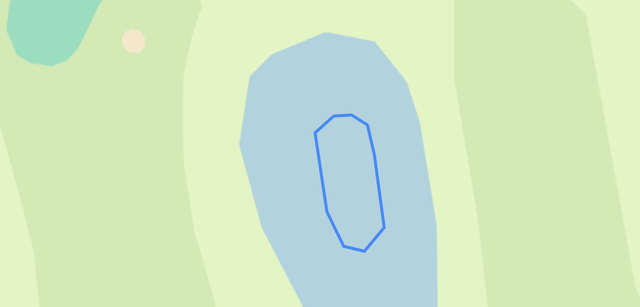
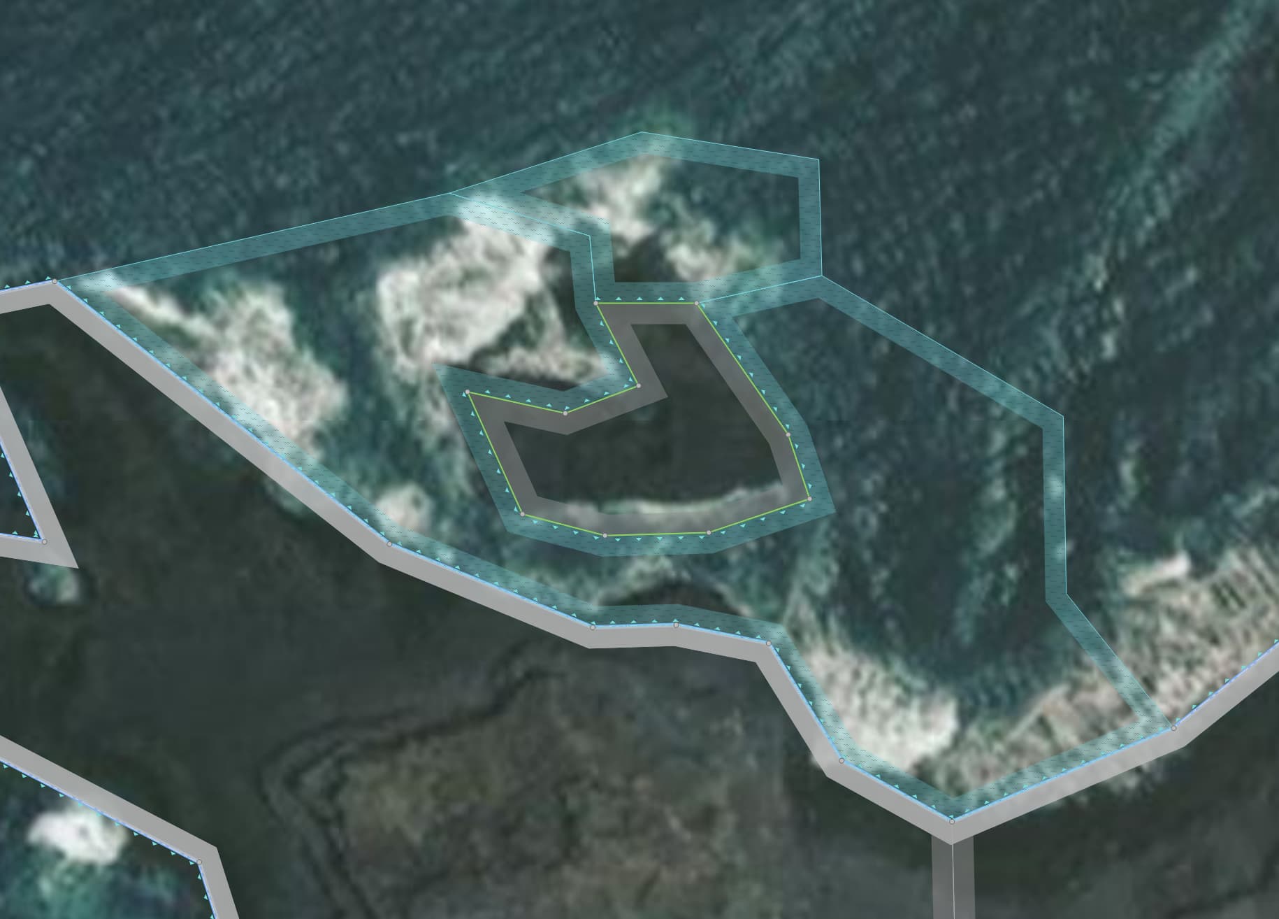
Related to the above, is this body of water correctly mapped? What is it supposed to represent? The islets within it indeed are not rendered, but IMHO the solution here would be to delete the body of water instead of making them inner polygons of a relation including the water area.
Hi @osmuser63783 I have looked at a few, but on a couple of occations I cant seem to find the surrounding waterbody doesnt show up on the list of relations. Do you know why that is?
An example is this one: OpenStreetMap.
@IBDJ In such cases, you should create a new relation having the waterbody as the outer member. In iD, this is as simple as selecting both the existing natural=water area and one or more (to-be-) inner areas and just selecting “Combine” (C on the keyboard). (I’ve just done that with your example).
The problem is, that the key place is not really the best for islets/islands, but this is how it historically developed. Maybe natural would be more suited, but the wiki page says it is discouraged.
Anyways, I think the common practice is to map them, even though this is somewhat against the general idea of place=. After all, there is currently no other way to map unnamed islands.
Also note that most of the time the correct tag is place=islet, because place=island is reserved for islands larger than 1 km² (See Tag:place=islet - OpenStreetMap Wiki).
Well, there is. If they do not have a name, and you do not feel like mapping any landcover on them, just draw a closed way (area) and add it to the water multipolygon as an inner member. If they are in the sea rather than in an inland water, just tag the way as natural=coastline and nothing else.
I guess, yes. But the merit of this is unclear to me. Apart from being admittedly inconsistent (classic OSM moment), I do not see the problem with mapping it as place=. Especially, because data consumers can more easily access the data. ANd for people only wanting named places, the can check for place= and name= .
IMHO the whole purpose of „place“ is names. An island is the same as bigger stretches of land, i.e. „not water“. Duja is spot on, the method for mapping islands is coastline and for inland islands cutting holes, adding place=island without a name will make nothing easier for anybody.
Almost done in Nederland with this Maproulette mission. I found it not that easy, especially the islands and islets which contain multiple overlapping landuse/natural areas and blank areas. Probably will get comments from more experienced island-mappers, whose overpass-queries (for maintenance workflows) I may have broken without knowing it.
… but with the caveat that there are lots of islands without names already, so data consumers like me need to deal with it anyway, so it’s perfectly OK for this challenge to concentrate on geometry and not worry about names.
Agree. If one has a multipolygon representing inland water, and it has an inner member (or members) that form a ring, in the absense of any other tags, one can assume it is an island. What additional information does place=island provide?
Well, if they weren’t tagged as place, finding those ~20,000 mismapped objects which triggered this task would be much harder :), since they would have to be identified by spatial analysis.
But other than that, yes, I agree, there’s no practical use of having unnamed place objects.
I found lots of place=islet without a name and without a landuse/natural. Verifying, I often see only a tree, some shrubs or reed above the water. If I just cut them out I create white spots in the water, without any detail. I think that is of no use at all. Adding the tree, shrubs or reedbed helps, cutting it out makes sure renderers don’t show swimming trees or shrubs. The place=islet tag does not add anything useful to that; at the same time, it doesn’t hurt either.
(What was that screensaver called again, with the marooned man on an islet in the Atlantic with one palm tree?)
There’s always a natural=water that surrounds the island (or there was when I sourced the data): that’s how I identified the islands to be included in the challenge.
For islands in the sea this may be a natural=water without water=, as in this example. I would have thought that people draw these objects to get a name label rendered, so if it doesn’t have a name I don’t know what it’s for. Could be worth asking the person who created it.
Sometimes there’s a subtag like water=*, that also gives a hint as to what it represents. In OSM Carto at least, natural=water is rendered with a solid blue fill, so it has the effect of obscuring any islands in it. The Caspian Sea alone (natural=water water=sea) obscures about 300 islands this way.
natural=water water=lagoon is another one that can be on the seaward side of the coastline.
Another one is water=bay where the mapper probably meant natural=bay.
You can find some odd objects this way. Ten islands are obscured by a natural=water water=ocean.
As you said, the solution can be to delete the water instead of adding the islands to it. But for large objects I wouldn’t do that without asking the local community first, or the person who created it.
Oh, I actually had missed it before: turns out there were not one, but two water bodies which together surrounded that first islet, but neither did enclose it:
Their only tags were natural=water, and they didn’t belong to any relation either (and they were created by the same user who created the water area surrounding the second group of islets. So I went ahead and deleted them as well.