Isn’t that tagging for the validator?
yes, but not incorrect one (if they actually have no names)
in the same way, tagging landuse=forest rather than teren=las (in Polish) can be described as “tagging for renderer” but is not “deliberately incorrect tagging for renderer”
local knowledge (yes, not applicable to armchair editing)
If you mean JOSM’s validator, it complains when an island doesn’t have a name, but it is fine with an islet not having a name.
It also complains when a small island is tagged as island instead of islet.
So changing the tag from island to islet - where appropriate - makes both validator warnings disappear.
1 Like
Interesting - that might explain why when I was looking at the size of islands and islets in UK/IE there were some quite large “islets” and also small “islands”. ![]()
I have in the past changed the type of island vs islet¹, depending on the size threshold from the wiki (which can be computed in JOSM). This is uncontroversial right? Or do I get ![]() ed now?
ed now?
¹After proper consideration of the element history, tags, etc.
1 Like
Sounds good to me, given that people may be using “island” for small islets because they don’t know that “islet” is a tag, and “islet” for larger islands perhaps because of a name warning.
1 Like
It is fairly uncontroversial, but not something to mass edit mechanically. The square kilometre limit is more like a guideline and I have let slightly smaller ones slip through when it made sense.
1 Like
Made sense in what sense?
Local language for “island” vs other words for smaller stuff, local opinion of what islands ar “major”, population, ability to support a farm, prominence and conspicuous, being the “main” in a cluster, de-facto area also including neighbours that are cut off on high tide.
None of these factors in isolation.
Island is a hairy concept with some objective factors and some subjective. Including that cultural context adds more value than a pure size cutoff. If it was just about size, a tag wouldn’t be needed at all (except for islands mapped as nodes?)
It is like how the place hierarchy isn’t just about population.
7 Likes
It’s great how many of you have started fixing some islands. We have already fixed over 500 islands, and so far the challenge has only been accessible to people on the forum here ![]()
I’ve slightly tweaked the task instructions based on comments here and made it discoverable to MapRoulette users.
Personally, I leave the tag on them even if they’re unnamed, and when I map a new island I add it. That’s because being role=inner to a water doesn’t say it’s an island, it just says it’s not water. There are things in lakes that aren’t islands, but also aren’t water. Buildings, for example: here is one on stilts, here is a water crib and lighthouse, here is a breakwater.
So I think having place=island/islet is clearer, because it tells me what the object is.
But it’s clear there are different opinions and a lot of islands don’t have the tag! So data consumers who want to, for example, count the number of islands have to handle both cases.
4 Likes
I got an “islet” without name and no landuse/natural, which is just a support for a mast placed in the water. Then I thought "hey, why not create boat roundabouts for waterways, can’t wait to map a counterclockwise turbo boat roundabout with waterbus shortcut and left-turn bypasses. Then I can map a centre islet. Preferably with an artwork in the middle.
1 Like
Is seems like you have a small duplication in the description (emphasis mine):
When a body of water, such as a river, lake or gulf contains an island, contains an island, …
That makes sense, but I assume most data consumers will already handle the case of a tagless way inner meaning that it’s an island/land by default. I do wish there was a tag for island/islet which did not carry the baggage of the place=* key.
I finished all of the tasks in Texas, except for one, which I’m not so sure on:
https://maproulette.org/challenge/43086/task/211358445
It’s a breakwater which is also tagged as an island. From USGS topo it appears that there might have been a “spoil island” in the past:

But from current imagery it doesn’t really appear to be an island anymore.
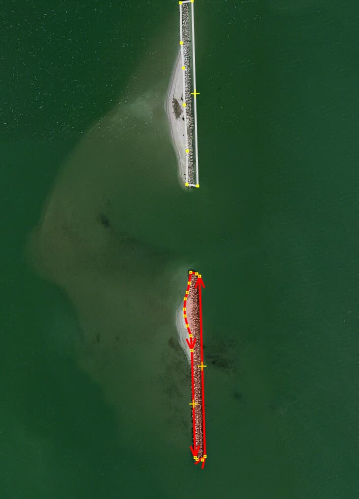
I would appreciate it if someone who is more experienced with this sort of feature could provide some guidance on what can be done here. My first thought is to just drop the tags related to the island (including the GNIS data) since it doesn’t seem like it’s there anymore.
1 Like
I’d be inclined to tag it as natural=shoal instead.
2 Likes
I would leave a note. It’s near a city and maybe there’s a local mapper who knows more.
It looks like a sandbank of sorts that the breakwater has been built on. If no traces of the island were visible I would agree with you that it’s just a breakwater but the bit to the west looks like sand. One option is to split it into a breakwater and a shoal (for both breakwaters in your picture). If you wanted to map it really precisely, you’d have to know how much of it (if any, apart from the breakwater) is permanently above water (coastline, islet), how much if it is tidal (e.g. shoal) and how much permanently underwater (reef).
Another question is if Spoil Island is a name or a description (or both), another question is if that bay should really be natural=water at all, or natural=bay.
1 Like
How would you proceed with a 10m2 pond with a 2m2 islet on a private property? I usually do not map such objects at all.
Draw a circular way and tag it as waterway=ditch, access=private?
PS ![]()
No need to draw anything, it’s already existing as described and part of the challange. It’s surely not a ditch and as it is within a private property I would not map it at all. So how to deal with? Remove it? Make a MP with pond + islet out of this spit stain? Anything else?