Intersections of Sidewalks and Driveways

(Continued from this thread about crossing:markings=surface|solid and this thread about crossing:continuous=yes|no)

Let’s discuss the intersections of sidewalks and driveways!

I’ll open with two examples that are likely representative of the bounds of this topic’s scope:

  1. A sidewalk intersecting a driveway for a single-family house
    - Very low-traffic
    - No crossing-like markings
    - No crossing-like signals
    - No crossing-like start/end differentiators (tactile paving or incline change) along the pedestrian travel path

  2. A sidewalk intersecting a driveway for a busy retail business
    - Very high-traffic
    - No crossing-like markings
    - No crossing-like signals
    - Crossing-like start/end differentiators (tactile paving and incline change) along the pedestrian travel path

How should these be mapped and tagged?

1 no crossing at all
2 highway=crossing crossing=unmarked (or equivalent tagging)

7 Likes

What is it, specifically, that makes Example 2 a crossing but Example 1 not?
(I feel like my tone is off, there - not trying to be argumentative, just asking for an explanation of the mental rubric you’re using!)

1 Like
  1. No markings, no signals, no other indications, and pedestrians have the right of way - here is not any indication for a crossing
  2. crossing like differentiators, esp. tactile paving indicates a crossing and that pedestrians should pay attention.
1 Like

This situation is very common - does this qualify as a crossing to you?

  1. A sidewalk intersecting a driveway for a busy retail business
    - Very high-traffic
    - No crossing-like markings
    - No crossing-like signals
    - No crossing-like start/end differentiators (tactile paving or incline change) along the pedestrian travel path

Maybe this depends from the local law. Who has the right of way? the pedestrians or the cars?
In Germany I would expect some indications (kerbs, markings, signs) at “crossings” with high traffic.

Example 1

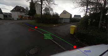
I have two examples with me that I would put in category 1: a driveway for a maximum of 2-3 houses, usually only 1 house.

Previously, I had always tagged them as follows, given that the sidewalk was mapped separately.:

crossing:markings=no
crossing=unmarked
highway=crossing

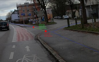
Example 2

As of today, this would make no difference to me compared to example 1. Except that the kerb value might be different.

New Example 4

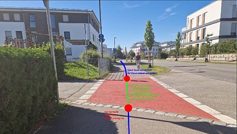
I would put all crossings that are marked with color and lines/dots in Category 2. No matter whether it’s just an access road to a house or a busy residential street. I tried to include as many different situations as possible, but at the same time I tried to keep the research time within reasonable limits.
So far, I have mapped these as follows, although I now know that this is wrong:

bicycle=yes
crossing:markings=dots;surface
crossing=uncontrolled
highway=crossing

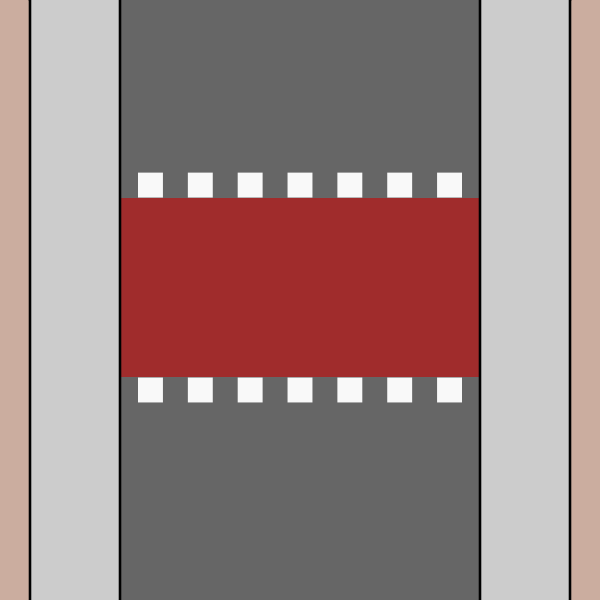
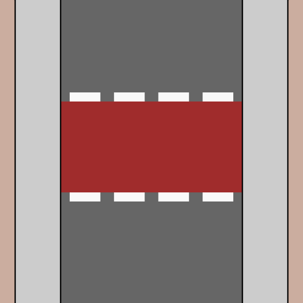
Proposal for a new wiki image

(in addition to the existing examples)

I created the following mashup from the two existing graphics, and I would like to add it to the wiki for all the cases I posted under Category 3.


The wiki already suggests the following tagging, although you should check whether to use the pictogram or not.

highway=crossing
crossing=uncontrolled
crossing:markings=dashes;pictograms
surface:colour=red

the line in your sketch is doted not dashed - but our cycleway crossings are short dashed

@ mcliquid - i could live with

  1. not a crossing
  2. unmarked
  3. depends
  4. is a mixture of crossing=continuous and crossing=uncontrolled with crossing:markings=dashes (it depends on the location of the kerb)
1 Like

(Lost track of time and late for something, so I’ll respond in more detail later, but this is what I “see” in these examples)

Yes, I realize that I am taking too long to write posts. When I formulated my example 3, the new post from Lumikeiju did not yet exist.

You are right, here is a new version:

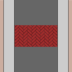
Furthermore, I would like to suggest that the current image for crossing:markings=surface be replaced with something like this to show that it is not only color but also surface texture:

What do you think?

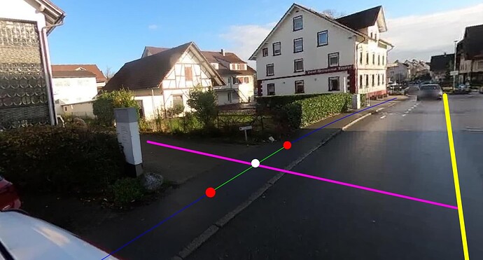
Thank you! How would you tag the point (Node) that is approximately in the center of the green line that intersects the driveway?
In this variation, the white dot crosses the green and pink lines:

highway=crossing nodes and footway=crossing ways share identical tags for the most part.

Some info on https://wiki.openstreetmap.org/wiki/Draft:Foundation/Local_Chapters/United_States/Pedestrian_Working_Group/Schema#Crossings_2 (note - this draft is written by me, documenting on behalf of the PWG)


One of the major benefits of the move from crossing=* to crossing:*=* is that the only way to account for all of the combinations of features and laws is to just (Edit: “just” was poor word choice here; I mean “simply” not “only”) map the objectively observable features.

I can be in a foreign country and still easily answer:
“Are there markings for this crossing?” (crossing:markings=yes|no|zebra|lines|...)
“Are there signals for this crossing?” (crossing:signals=yes|no|...)
“What is the surface material of this crossing?” (surface=asphalt|concrete|...)
“Does this crossing continue without interruption from the intersecting roadway?” (crossing:continuous=yes|no) [this one is contentious, I guess?]

There’s no way I could somehow derive crossing=pelican from standing at the corner of an intersection.

1 Like

Maybe we have to read here what was the final decision

You are right, and I rememerd wrong, it was finaly described as highway=crossing.

But was there also a discussion about driveways?

What crosses what?

We are very familiar with, footway and cycleway crossing a road, use. We use highway=crossing on the node.
But is there also an opposite, where a road section crosses else, the footway, cycleway? That opposite thinking. We are already articulating this view in communications, as, driveway crosses a cycle path. Is that the case when accessing a yard. Is there a tag for that? highway=xxx_crossing Should there be a clear distinction. I see that mappers use, highway=crossing, actually use improperly.

driveway:

Where does a driveway start?

Legally.
The road, what belongs to the road?
The verge, as well as footpath and cycle tracks lying in the verge, as well as the branch to the entrance to the yard. (landuse=highway)
This branch is (mostly) maintained by the government, there are those places, that the use of this branch has a function other than reaching the yard, a through function, crossing function, for users of the footpath and or cycle path. The government is deliberately make use of this to construct the network for these users in this way. On two sides is a footpath (sidewalk) these branches (to yard) are used to get from one side to the other, so it does not only play at junctions. It can be reasoned that you say, I am not using a driveway at that time, so that branch should not get service=driveway. If that is the case then it may adversely affect navigation calculation, if one decides not to use service=driveway in navigation calculation. An OSM cut will then be desirable and give that part only `highway=service’ with ?.

The branch is not legally owned by the yard owner. A reason not to navigate over driveway.

I have seen that OSM mappers, also gave this branch highway=unclassified residential, which makes you think. Why they do that, is it some logical feeling.

The driveway starts on the property land.
The branch, it is more of a service=driveway_link.

Although, everybody, me included, call it the driveway in general.

But OSM is describing the parts, including the driveway (general) and the different elements.

As a OSM mapper I see different functions.
Thus, I understand the approach of other mappers, who did things differently before.

And I can pretty much go along with that. But how, is it better tagged?

``crossing:continuous=yes|no` ```

Term,crossing, has a clear connection to one, the general foot and cycle crossings, we are now talking about the other, for which we should then not use the term crossing, but xxx_crossing or something similar. That the distinction is more understandable.

My general rule is that any intersections between a highway=service and highway=footway/cycleway/path is unmapped unless proven otherwise. As such, I only use highway=crossing (and by extension footway/cycleway/path=crossing) at the level crossing=uncontrolled or higher and crossing=unmarked only if the sidewalk has a clear divider (this often times also means a change in surface which is a valid reason to split the road). The main reason is the danger of getting an overabundance of “warnings” and falsified navigation weightings and the resulting inconvenience for both parties of traffic modes (it’s actually why crossing=informal is tagged without highway=crossing) and the other reason is the usual amount of traffic you can expect as a pedestrian/cyclist/etc.

This is different for a public street where the expected traffic is usually higher than that of a service road but also because the sidewalk gets disrupted more often (this also is the reason why crossing:continuous=yes has to be specifically added to them because continuous sidewalks are the exception, not the rule).

On that aside, my general rule is that crossing:continuous=yes only exists as a node, not as a way due to the lack of verifiability (in that it isn’t “clear” where the crossing for pedestrians/cyclists starts and ends) and how it’s the footway which bisects the street, not vice versa.[1]

So in the images...

I see no footway=crossing.

Ditto.

This is a crossing, though.

So is that.

Even beyond that, trying to split a highway=footway at every driveway crossing will only result in fragmented footways, which makes them too impractical to work with.


  1. Which does mean it’s perfectly valid to split a road at one, lest because of surface information. ↩︎

4 Likes

Thanks, everyone, for sharing your perspectives :slight_smile:


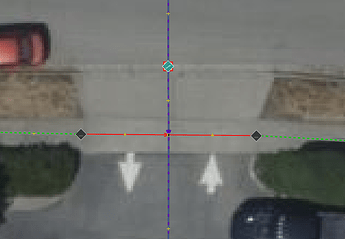
Let’s take a look at this very common situation:

If you believe this is not a footway=crossing - how would you like to see it tagged?

(“I wouldn’t map this!” is not the point; assume others are mapping them - because we are - and the goal is to limit the dilution of the footway=crossing and highway=crossing tags by mappers like me by having a different tag for “not-crossings” that aren’t in the primary roadbed.)

As for why I care to map them: These are locations where my risk as a pedestrian of being hit by a car is quite significant. I want routers to be able to route me along the north side of the street that has 40 ft of “not-crossings” vs the southern side of the street with 200 ft of them.

I want those with vision and mobility impairments to be able to know when they’re moving from a relatively safe sidewalk into the path of reckless vehicles, whether there are incline changes or tactile paving surfaces on either side, and the length of the “not-crossing”.

Yes, I guess it’s technically possible by looking for width=* tags on any intersecting highway=service, but in my experience that is very infrequently tagged.


Random aside: “not-crossings” keeps reminding me of “not-turtles” from The Mercy of Gods, which I really enjoyed.


Thread continues here: Intersections of Sidewalks and Driveways - #35 by Lumikeiju

2 Likes

this is footway=sidewalk. the driveway is crossing. But please don’t split the 1 m long part from the driveway that is on the footway!

2 Likes

[Edit: The merge of this post and the relevant portion of the previous one starts here, so there is some discontinuity in discussion flow!]


One thing OSM editing has really opened my eyes to is the incredible diversity of our constructed environment - when we’re trying to work out the edge cases to harden a globally-compatible schema, we eventually run into entire cities or countries which have such a massively different perspective because of their unique environment and lived experiences that I hadn’t ever considered.

I think “this location is one where different traveler types have a high chance of colliding because their paths intersect” is about as good of a definition for a crossing as I can come up with. It’s my understanding that UK English only uses the tern “crossing” for what we in US English call “crosswalks” (pedestrian paths, often with legal priority specifications, within a roadbed) - but I think that’s an unnecessarily limited scope, given the range of on-the-ground features.

Tags are important to help iteratively refine the different types of crossings (that’s why we have crossing:markings=* and crossing:signals=*) and I wonder what would be a good tag to define these minor sidewalk-driveway intersections - any suggestions?

I could even maybe see it as a refinement of sidewalk=* but that could become messy especially considering that similar situations occur along cycleways and paths.

3 Likes

It is also worth considering whether a tag is necessary at all to identify such intersections. With a bit of processing, it should be possible for a data consumer to identify any node that is part of both a highway=footway + footway=sidewalk and a highway=service + service=driveway. There might be some reason this is not good enough to identify minor sidewalk-driveway intersections, but it also might work just fine.

4 Likes

There was a fair amount of discussion how to tag sidewalk-driveway intersections here, last July, in one of the threads about continuous crossings. I think most people agreed that they’re not “proper” crossings (= crosswalks) but it could nevertheless be useful to have a way of tagging whether or not the pavement is continuous or interrupted, whether there’s a kerb, … A few suggestions were made, not sure if any have taken off.

2 Likes