Hwy 1 from Santa Cruz to San Francisco is expressway=yes?

I noticed that on the OSM Americana map that Highway 1 between Santa Cruz and Pacifica is shown quite prominently (see screenshot).

This appears to be because it is tagged as “expressway=yes”. This particular stretch is really rural and the road has plenty of driveways and other small roads that intersect along the way. This seems to be in conflict with the wiki for tagging “expressway=yes” which recommends to only use “expressway=yes” on undivided highways when there is “full access control”.

In light of this, would anyone take offense if I went ahead and removed the “expressway=yes” tag from this section of Highway 1?

6 Likes

I agree that this stretch of Highway 1 is a far cry from an expressway. It should remain highway=trunk due to its importance to a connected road network; that will coincidentally maintain a high level of visual prominence in this particular renderer.

No passing zone near Davenport (© 2017 daryldarko, CC BY-SA)

Passing zone and driveways near Davenport (© 2017 daryldarko, CC BY-SA)

1 Like

I don’t have much to add except that I agree that it is not an expressway, but trunk makes sense to me. Plenty of buildings, businesses, and driveways directly adjoining it without access control or median and also an important regional road.

On the extreme end of things, it maintains this tagging even in Pacifica (below) as you encounter traffic lights and driveways to numerous businesses (and similarly in Half Moon Bay)

Less extreme, but still very not expressway to me is Davenport where there are buildings and driveways right into the highway.

And this type of thing is happening in smaller amounts all along the length.

1 Like

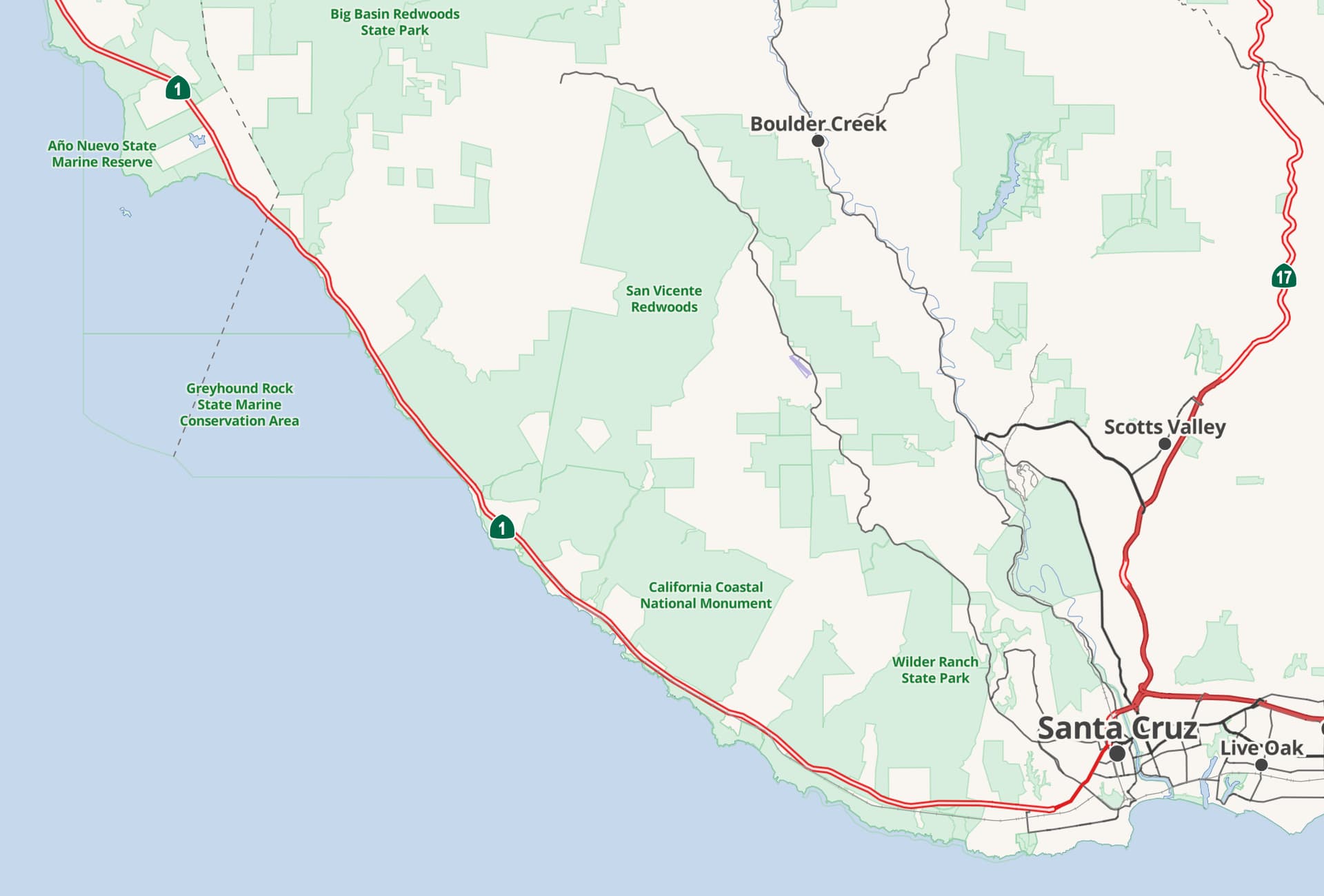
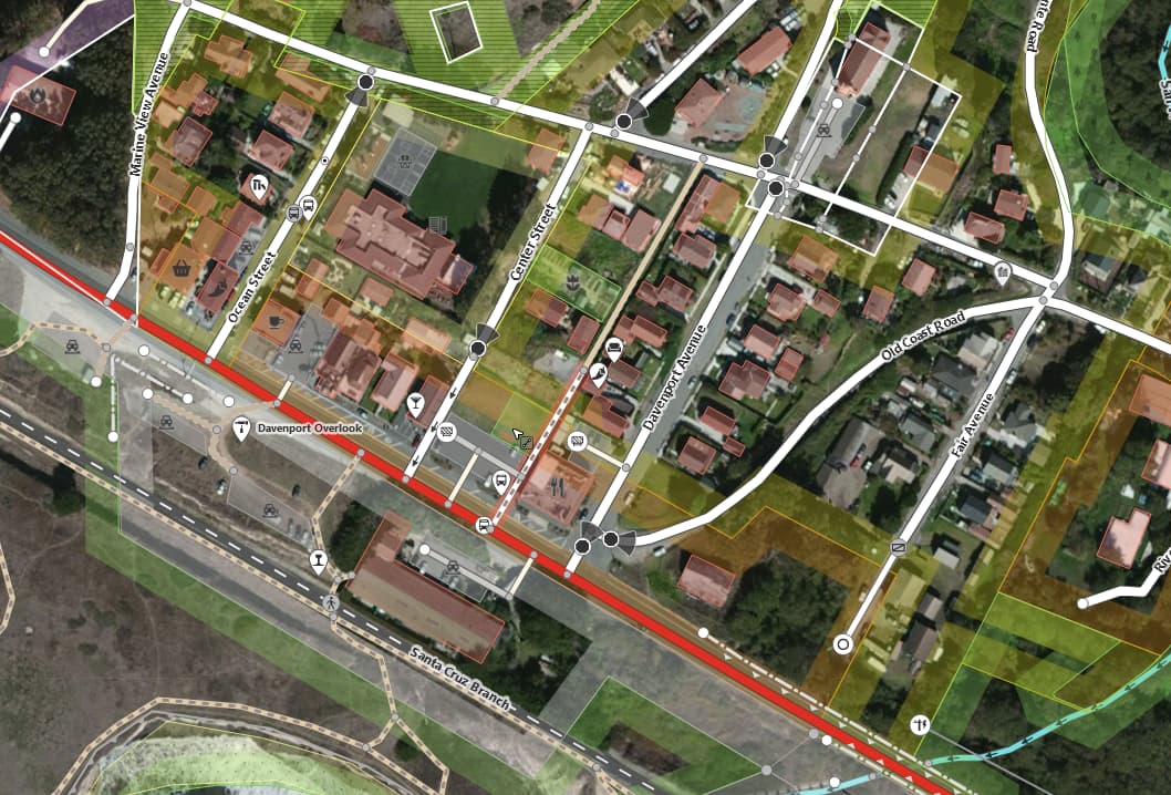
Minh and I are fairly local to one another, though I’ve lived in Santa Cruz for decades and have driven this road hundreds if not thousands of times. I’ll explain that there is a lot of history of this road being tagged with various tags over OSM’s nearly two decades. We are talking about the segment from Santa Cruz’ Swift Street westerly (logical north), including the signalized intersection at Western Drive, all the way to Ridgeway Drive / Fairway Drive (Pacifica), where north of there the road becomes signed, de facto, de jure freeway.

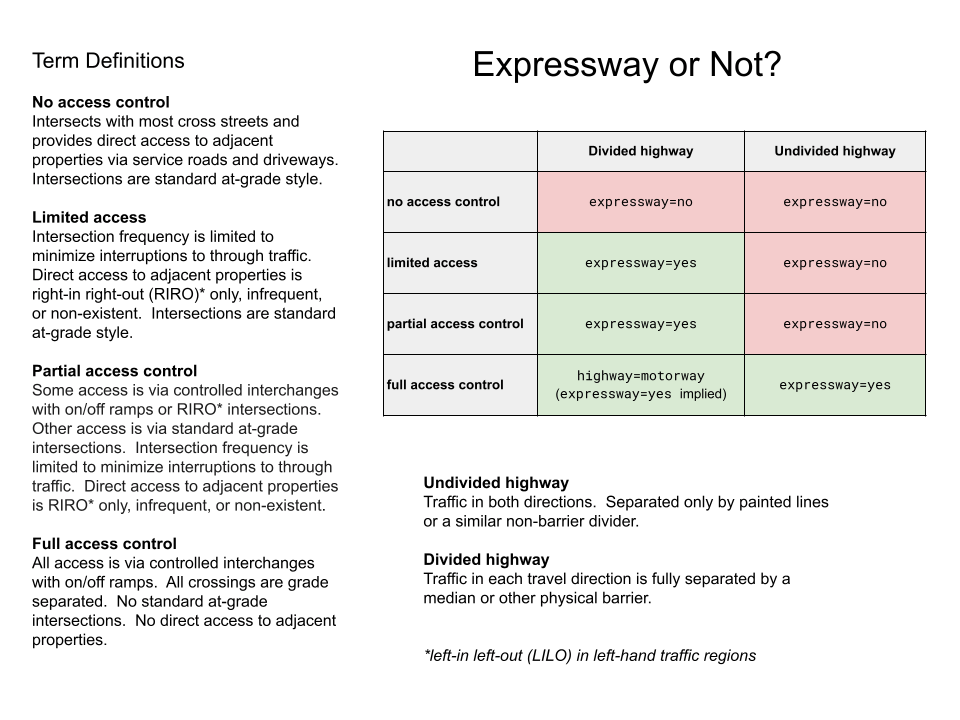
As “trunk” became re-defined since we now call it more-logical-to-network (rather than with physical characteristics) and “expressway” became a newer tag to express “high-speed travel” (among other characteristics), tagging this road in OSM has always been difficult. More so now that our own wiki for expressway states “expressway tagging can be somewhat subjective.” Yes: here we go again.

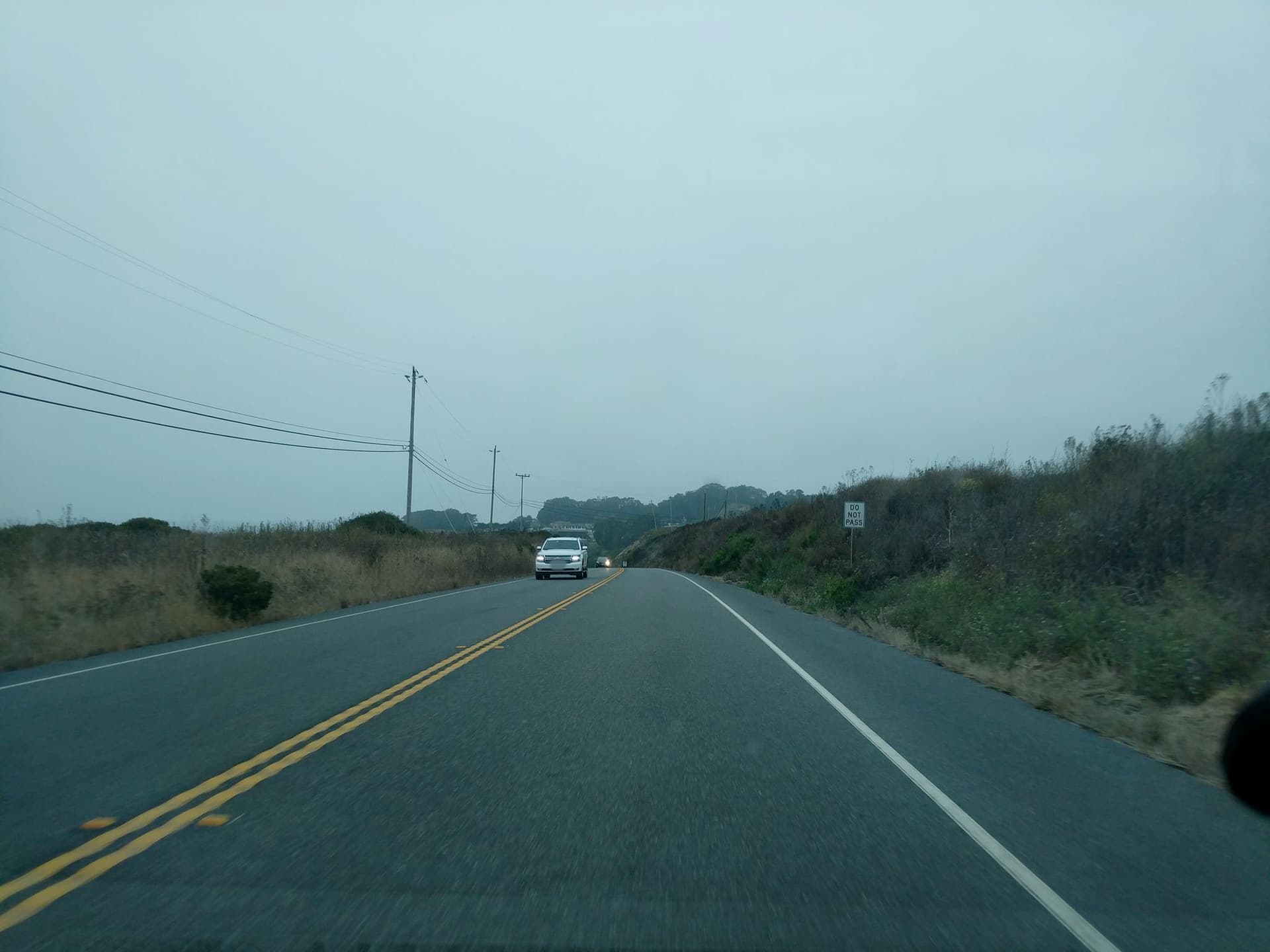
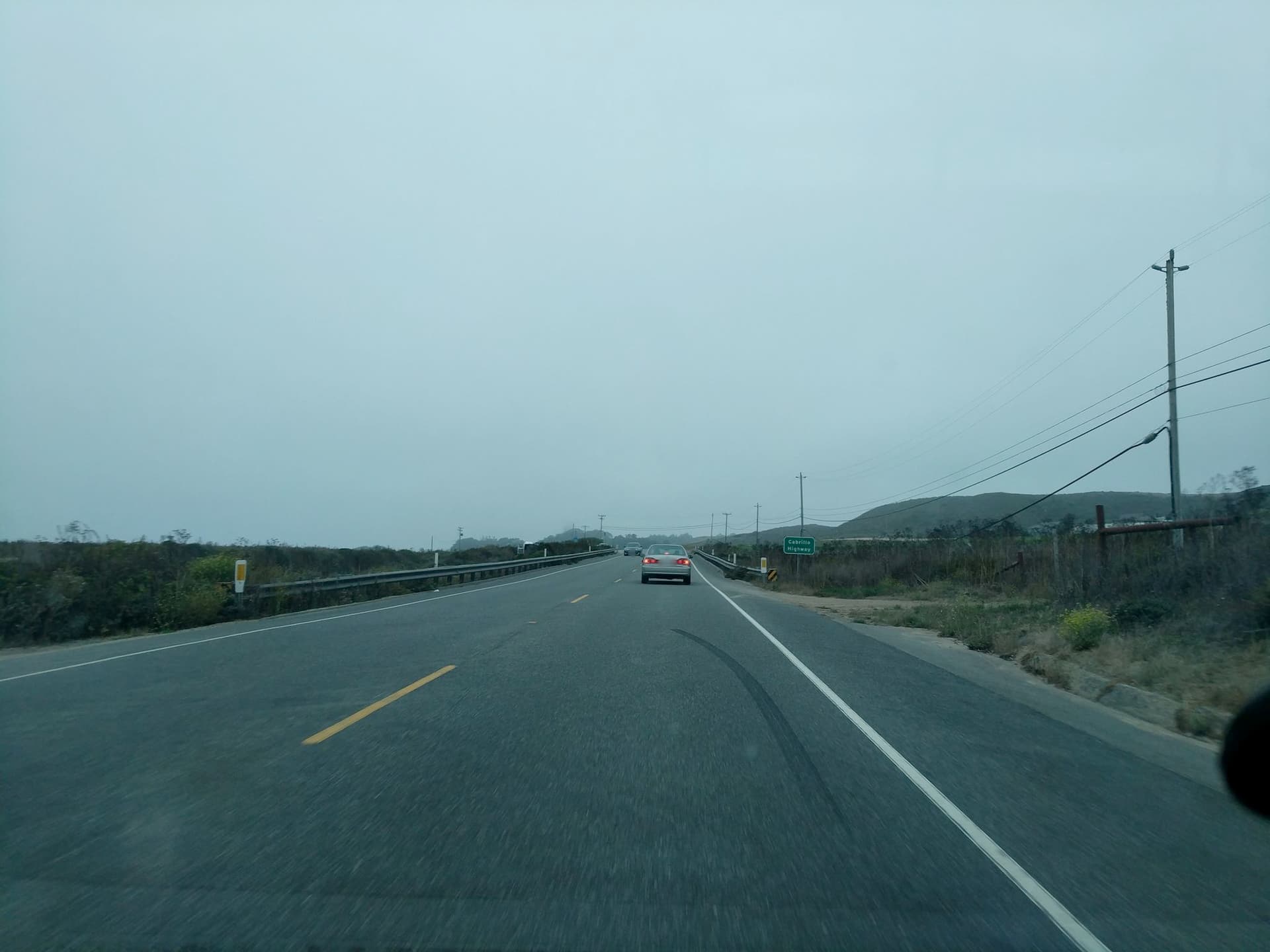
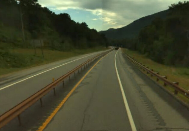
This is a higher-speed rural road connecting cities (Santa Cruz <=> the southern reaches of San Francisco’s urban areas), with some “villages” (Davenport, Montara, Moss Beach, Granada…) and at least two “towns” (Half Moon Bay, Pacifica as definitions seem to allow extents to continue that far) along the way. By “higher-speed,” I believe the speed limit along much or most of it is 55 MPH, although there may be some 60 or 65 segments. When traffic is light, I find traffic at even higher speeds (70 MPH is not uncommon, though of course, that risks a speeding ticket; my point is that the road is capable of those speeds, and even those much higher than that; I invoke my 5th amendment right against self-incrimination to not say more).

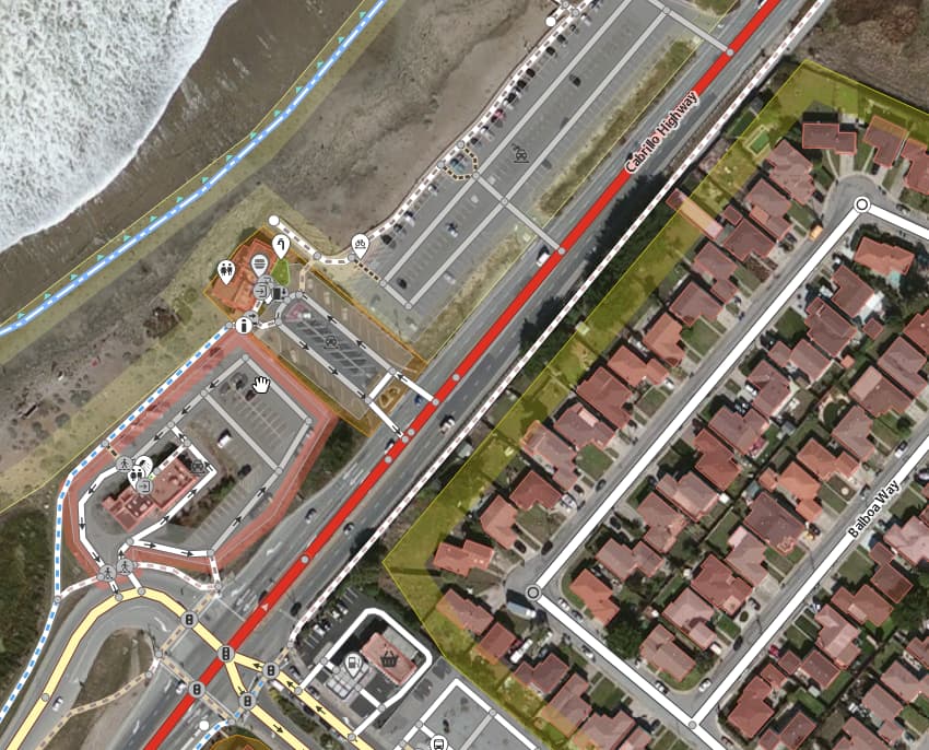
Yes, the road is two-lane and undivided for much of its length, though there are segments where it is three-lane (a passing lane on one side) or even four-lane, but seldom with center median. Much of the reason I tagged this expressway=yes is to characterize the very different nature of the road between “in Santa Cruz” (Mission Street between Swift and Chestnut) and “outside of Santa Cruz.” (Strict city limits are not what I mean by that). “In” Santa Cruz, the road is a congested, lower-speed trunk that defines “Westside commercial district” (Swift to Laurel) and “Westside professional district” (Laurel to Chestnut). To be specific, when traveling logical north / physical west, the difference between Mission @ Swift (a 25 MPH, four lane “business district” trunk road) drastically changes after the signal at Swift (even to the signal at Western and beyond): it “opens up” in width and becomes a 50 MPH (at least) higher-speed road for the next 70 or so miles, with a few exceptions (like through Davenport, where the character of the road doesn’t dramatically change, but the speed limit “through the village” drops to 35 MPH). That makes it worthy of an expressway=yes tag.

Yes, Hwy 1 here is 100% certainly characterizable an expressway between Chestnut and River (in Santa Cruz); this is known locally as “the Bypass” and has a speed limit of 40 MPH (recently down from 45), but it isn’t the legally-defined freeway further east (logical south) of River Street. But, the segment “through town” (Chestnut to Swift) is most certainly not expressway, so it isn’t tagged that. West (north) of Swift I have tagged this expressway=yes, because it is a higher-speed road that fundamentally changes at the boundary of Swift Street.

I have mixed feelings about removing expressway=yes from these 70 or so miles of road. We would lose the fundamentally-different characteristic of the road as it exists “in” and “out” of Santa Cruz (where it quite radically changes in nature at Swift Street) and OSM would also have no other way of characterizing it as a fundamentally high-speed road, distinct from low-speed “in town.” Mmmm, if we were to better tag with speed limits here, that would help. Though, I want to hear (read) what others continue to say here, as all of this is quite a lot, and I’ve always had some difficulty tagging Hwy 1 between Pacifica and Santa Cruz (including IN Santa Cruz as Mission Street). Thanks for good dialog.

1 Like

I too appreciate the dialogue here. I’m also personally familiar with this road, as a former Pacifica resident (and it’s quite scenic, I might add). I’d tend to agree with others that CA 1 between the southern end of the freeway in Pacifica and the western edge of SC doesn’t really match the definition of expressway=yes that predominates elsewhere, both in the Bay Area and around the US. For example, I think the segment of CA 1 between River and Chestnut in Santa Cruz is a good example of an expressway, as are the bits of CA 17 that aren’t up to freeway standards (both are currently tagged as expressway=yes).

I do appreciate @stevea’s point (and I think we discussed this in PMs before in fact) that the “quality” of the road does change appreciably in its transition between an urban thoroughfare and a rural, high-speed road. I agree that the best way to express that consistently in OSM tagging is probably via better tagging of speed limits, lane counts, etc.

2 Likes

Hello, great to see you posting here; welcome!

Especially after you saying this (and others have, too, it seems), I find myself leaning more in this direction. Let’s keep up the dialog. What do others think? What about removing expressway=yes from this (~70 miles) of road if we were to accurately tag it with speed limits and better lanes=* tagging?

3 Likes

I think that makes a lot of sense - I think you made a lot of good points about the character of the road warranting some additional information, whether expressway tagging or something else. It also had me thinking of other segments of CA 1 north of SF in Marin/Sonoma/Mendocino that have similar qualities - wider, faster, less windy/more straight for some stretches. I think getting good data for speed limits, lanes, etc best matches how I hear others tag roads and keeps a more consistent understanding of what an expressway is, but I know all of you in this thread have been dealing with these tags for far longer than I have.

2 Likes

Right, “going a bit more broad” (geographically), and north from the Bay Area onto Humboldt/Mendocino Eureka (101 and 1) there are similar “stretches” of road that are not easy to characterize in “a tag or two” (or maybe even three), yeah, “more coastal California trunk tagging” sounds about right. (Other mappers where similar fuzziness exists, of course are welcome to follow!)

Yes, speed limits and lanes, that’s what we’re trying to say (mean) here, so yes, let’s let that/those be the (better) tagging we do here. We can tag higher on the quality bar on these: a trunk where we switch on or off expressway is a simplistic paintbrush. I’m sometimes not of perfect memory about where speed limit signs are, but I’ll keep my eyes open and map sharper; good.

Ever since the expressway=yes tag emerged, (my momma didn’t have tell me), I knew there’d be days like this.

BTW, this all feels so familiarly OSM-ish: we get some fuzzy “80% or 85% OK” tagging not in firm focus plugged in, then we dress it up all nice and properly because it sharpens up our tagging. I’m smiling and nodding, here. Good talking about it more widely. It’s awesome when “locals like us” look around and find we are more-or-less in the same room talking about something we all know something about.

It’s been true all along but I’m glad we’re “saying it out loud here and now about this:” let the crisply-specific tagging begin and continue!

As I think about this, I just ducked out some expressway=yes tags through Davenport. Changeset: 131251263 | OpenStreetMap . So, it’s all still highway=trunk, but “downgraded” to not have any expressway tag at all in the areas where speed limit signs reduce (from 50 or maybe 55?) to 35 MPH. That’s a good start. As I see speed limit signs, I’ll “pepper those in,” too. Go, team.

More editing like this through Pacifica wouldn’t surprise me.

Changeset by changeset, our map (data) improve(s).

I agree that the “expressway=yes” criteria of having a high speed is met. However, I believe the primary disqualification here is the matter of access control of which there is very little along the whole segment except for maybe the section in Santa Cruz between Chestnut and River due to its median barrier.

The wiki for tagging “expressway=yes” includes the following graphic that says for undivided roads, “expressway=yes” should only be used in cases with “full access control”.

Given the very strict threshold of “full access control”, this makes me think the expressway tag should be set to “no” for nearly all of the highway between Santa Cruz and Pacifica.

3 Likes

Hi Evan: I have seen this wiki table (and re-read it recently) and it makes me say “hmmmmm.” What I mean by that is that it is well-written, though I will remind that expressway is a relatively new tag, its parameters (while not disputed) do not seem to be widely accepted nor applied, and as that we do apply them (or propose / question that we do, as you are here), there will be some (wider, slower) community consideration about this. I’d like to continue to allow the community to offer input here, as it seems the feedback we’re receiving is “so far, so good.” But I don’t think we can come to any hard-and-fast conclusions, at least just yet.

It is entirely possible that the entire stretch of 70-or-so miles here DO have expressway=yes tags removed, completely. While Davenport is a good start, it is “something, rather than nothing” and we may have much more to go. How much and how fast? I think that is a more medium-term (rather than short- or long-) endeavor; I believe we benefit from listening to further input from others.

BTW, there is no dispute that “the Bypass” (Hwy 1 between River and Chestnut) IS correctly tagged expressway=yes.

1 Like

It sounds like this 70 mi section is undivided and has very limited access control? @stevea by what criteria would you use to classify this as expressway instead of simply trunk? I don’t think speed limit is a good criteria since we have many trunk and primary highways throughout the country with 65-75 mph speed limits.

I’m not familiar with the California road, so I won’t comment on it, but I will trot out the example of the Franconia Notch Parkway (section of Interstate 93 in the New Hampshire White Mountains), where the Interstate winds its way through a narrow mountain pass by the former “Old Man of the Mountain” rock formation (like the one on the NH quarter):

The highway drops from a 4-lane divided freeway, down to a 3-lane divided freeway, down to a 2-lane divided freeway, and then briefly down to a 2-lane undivided-ish road, before resuming traditional Interstate quality on the other side.

By mutual agreement, the mappers in that area designated that a highway=motorway even though a very strong argument could be made for trunk + expressway=yes.

So I think there’s room for a bit of local squishiness based on what makes sense in the context of the area.

Brad, it is “largely undivided,” but it is divided in (short, minor) places: immediately W of Swift in Santa Cruz, again through southern and central Half Moon Bay — but there are signalized intersections there, making expressway=yes less apt, but still possible, in my opinion, at the new widening on both sides of and through the Devil’s Slide Tunnel, through much of Pacifica (though again, part with signalized intersections, part not). These divided sections are a small minority of these 70 miles.

What is unfolding here for me is that I’m succumbing to my reluctance facing newer re-definitions of older methods of tagging in OSM, and it wouldn’t be the first time that’s happened. It actually causes a fair bit of friction in our project, without it actually being identified as such (very often). In my mind, these 70 miles are “high-speed trunk.” In my mapping, this stretch has always proved difficult to tag. In our discussions, OSM (in the USA) seems to have settled upon more crisply defined (and broadly accepted? maybe not among old-time mappers like me, though I’m not so brittle I can’t learn newer tagging conventions) tagging conventions for trunk, including what we mean by expressway=yes.

I’m having a public, inner-monologue-out-loud experience of “yeah, maybe Evan and Brad (and others, including our wiki and that nice graphic…) are correct here, and I simply need to get with the program.” On the other hand, Brian says “local squishiness can exist” and I’m back to stroking my chin about this.

I continue to listen (read more here). My “leaning towards” removing the expressway=yes tags continues to “lean more strongly” towards removing them for the whole portion. However, without speed_limit data on the road, that somehow doesn’t feel right. Yet, I don’t have the sped limit data tagging to add (accurately, without a careful re-drive and re-survey, and it is raining cats and dogs out here now). BTW, thanks Brian, for those graphics and the info about those segments of I-93.

Undivided-ish is a fitting term here because although this section is only divided by guardrails, it is never truly undivided. It’s not uncommon on urban freeways for the the travel directions to be quite close like this, though usually divided by something a bit more substantial like jersey barriers. I’d say rather than the choice of physical divider, what really puts this section below freeway standards is that doesn’t meet the minimum 2 lanes of travel in each direction.

image

In my opinion, the squishiness is appropriate in this case due to the short length of the substandard section (just a few miles) and because the Interstate designation gives it a bit more weight toward a higher classification. On the other hand if a persuasive enough argument were made to downgrade this section to trunk + expressway, I wouldn’t have a big problem with that.

Ah, cool, I stand corrected. I was going by the video which showed sections with floppy pylons, but there was obvious construction going on so the guard rails were probably just missing temporarily and it’s been awhile since I last personally drove it.

Zeke, your photo is quite helpful. Yes, if that interstate (as in the photo) were to be “reduced” from motorway to highway=trunk and expressway=yes, that seems correct. Especially given the sense of controlled access being well extant (it IS an Interstate, after all).

In the case of Hwy 1, it is one-lane (each direction), so two-lane, part-three-lane (a passing lane) and part four-lane, but it is seldom divided. AND there are numerous non-controlled access (side roads, driveways…) which seem to strongly contradict expressway=yes. For the latter, I can see eliminating the expressway=yes tags along the segments where there ARE driveways (Davenport is an example, though the reason I did that there is because of a reduced maxspeed through there).

There’s a fair bit going on regarding these semantics. I am getting closer to removing the expressway=yes tags from the entirety of the road, though I am glad to see the lively discussion here. (Today is Saturday, maybe?)

I find expressway=yes to be a tricky tag because it encompasses a few different aspects of highway design, but after over a year of discussing with other mappers and thinking it over, my one sentence definition is this:

expressway=yes: A highway that is similar to a freeway/motorway in some ways, but does not meet all qualifications to be classified as one.

More details are discussed on the wiki page, but fundamentally I think this captures the purpose of the tag.

So does this 70 mile section of CA 1 feel similar to a freeway? I’ve only driven it once, but I remember it feeling like a rural, undivided highway where you could drive quite fast on many sections but then you slow down when going through towns. In many states, rural highways like this can have quite a high speed limit, but I don’t feel like I’m driving on a road that is similar to a freeway just because I’m going fast. Mostly what makes a road feel freeway-esque to me is if there is some level of access control.

These 70 miles are “not usually” similar to a freeway, but in some sections, are. For example, those segments where there are four lanes (two in each direction). But for the most part, those four-lane segments don’t have controlled-access, in fact, there are side streets and driveways along those (not frequently, but they exist).

I like your “one sentence” definition. Hwy 1 is certainly not a freeway here, and in fact is “not usually” even similar to a freeway. In that sense, you might automatically say “well, then, even with the trickiness of the expressway=yes tag, don’t use it here.” And you’re likely correct. But then there are aspects of it which are, like where it is four-lane (and high-speed).

“Rural, undivided highway” is substantially correct for the great majority of this road. I’m leaning so much at this meaning that expressway=yes does not belong here that I’m just about falling over.

OK, community: I’ve succumbed to what appears to be correct here. I’ll remove expressway=yes tags on these 70 miles. Thanks for engaging my inner monologue and “getting to yes.” Erm, removing yes: I don’t think the expressway=* tag (with yes or other value, including no, I find expressway=no to be odd, but I imagine it useful in some cases, not this one) belongs on this road after these discussions.

As I’m on a mobile device typing this, and such editing would be better done on my 5K Retina desktop with JOSM, maybe sometime this weekend or by Monday at the latest I’ll “downgrade” these 70 miles.

1 Like