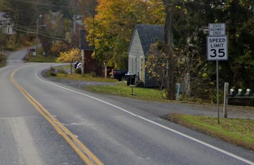
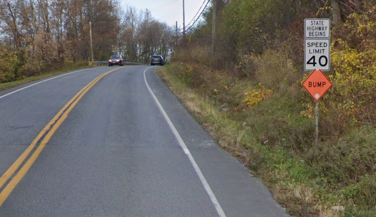
I definitely get this distinction. Rural highways often have a different character in town vs out of town. In Vermont you’ll see “State Highway Ends” signs as you approach a town:
I know I’ve seen some paper maps that use a slightly different line style as highways pass through towns, although I’m failing to find examples right now. As this discussion has concluded, expressway is probably not the right tag for this, but it could be an interesting distinction to tag somehow.
Zeke your putting a bow and ribbon on this is great: there really is a different character to certain roads where absolutely no classification change (or expressway=yes tag is appropriate, as we’ve seen here) happens in OSM. Hwy 1 at Swift is one of these: easterly (into town) it becomes 25 MPH congested commercial district and westerly it (briefly, for only about 100 meters) “blows open” to a four-lane, higher speed (50? 55?) “well, we’re driving all the way to Half Moon Bay or San Francisco now…” road with a very different feeling from “those were the last restaurants and gas stations we’re gonna see in a while.” Well, there IS the signal at Western Drive, a bit of an anomaly as there aren’t signals for maybe 50 miles to HMB. Mmm, OK, there is sometimes a “hanging flashing red” (yellow for thru traffic on Hwy 1?) at the turn to Pescadero that comes and goes with construction and/or some washouts that happen along there…or is that San Gregorio California State Route 84?
Maybe somebody has a think and coins a tag for those kinds of road transitions you’ve kindly shown us with photos (or calling the roads on either side one thing different than another), but I’m not hopeful we’d get to wide agreement on that, even though in OSM, almost anything is possible.
I didn’t know that expressway was a new tag, but the way I leaned towards an interpretation of it did seem to align fairly well with the description of access control being an important criterion in deciding when to tag it yes or no.
That is very interesting in Vermont! You can actually see the pavement change which signifies that the state highway truly ends at a city boundary in terms of who maintains the physical road. Over here in California, I believe that Caltrans still has jurisdiction and maintenance control of these roads even within the cities.
Well, expressway=* has been around since 2010 or so, but it “languished” for many years. Checking wiki history, I myself was one of the earlier editors of it in 2019. Around then, maybe early 2020s (2021?) a more sharply-focused version of it for the USA began to emerge, and of course, Americana has been around for a year or so making it render in a way we can see that makes sense to our USA eyes. (Yes, I remember those old gas station maps from the '60s and '70s and have some in a closet somewhere; those really are a culturally relevant way Americans “see” highways being mapped. Back then, the Interstates were a lot of dashed lines: not built yet!)
And yup, expressway implies pretty strict access control, absolutely.
So, yeah, the tag itself isn’t new, but its use and combination with highway=trunk has undergone a restructuring in the last few years, and I suppose I’m not fully used to it yet. Though, with the tagging I’ll finish on this SF <=> SZ segment of Hwy 1, I’ll get better at “the more modern way” we’re using these tags in USA.
I also noticed the pavement change in Zeke’s photos. Yes, as far as I know, Caltrans (our DOT) “owns” all highways “through” cities, and in the city limits the city might be able to offer input to Caltrans, but Caltrans has the final say. I think.
A bottom line to all of this is that this segment of road has always proved problematic to tag in OSM. I think we’re getting it closer to correct, especially as I and others intend to add maxspeed=* and lane tagging.
Yes, and that fits in just fine with my one sentence definition since to me stroads don’t feel similar to freeways at all. I’m sure someone might argue that they do though.
@stevea please have a look at edits by a new user HopkinsKat in relation to the PCH and tagging along SR 1. There have been some reports to the Data Working Group on highway classification tagging and I’m not a local expert on this matter as much as you, another others in this thread, may be.
Thanks for the heads up, Elliott. I’m not sure I’m an “expert” either, although I have had a “long view” of how certain tags and their semantics have evolved over the 14+ years I’ve been editing OSM. I am a “local” to (northern) California and I am “somewhat” familiar with what some, many or even most highway=* tagging “should” be. Though I may be only rather slowly getting my sea legs on expressway=* tagging, however, especially after this thread, I have had my eyes opened as to how people intend for this tag to be used.
The results of a lot of this contributor’s edits seem to be to create lots of new “version 1” ways, as if there is a lot of splitting of existing ways, but I can’t quite get my head around exactly “what’s the point?” (or why).
What, exactly, are the “reports” (complaints?) about here? I see HopkinsKat is doing a lot of Hwy 1 tagging, but I don’t see much (if any) expressway=yes tagging. I also see a very new contributor, as the account has only been existence for a few weeks. This wouldn’t be the first time we have a “naïve tagger” who simply doesn’t understand what’s right and what’s wrong. However, I ask again: what exactly is being complained about as “wrong” here?
Feel free to connect with me on a less public channel, too, if you like.
Thanks Steve for looking and your consideration! Public forums are good for me as a measure of transparency is ensured. The complaints are on the subject of highway reclassification that are not in line with the community’s own guidelines. CA mappers have a wiki article listing best practices and it would appear these edits fall outside of those norms.
Very likely just a naivety-type moment here that is resolvable with some mutual understanding. I posted here to get some more eyes on the matter just so that I have some consensus.
Just to be clear as to what I do see: the results of this tagging seem to be that many ways of Hwy 1 around here (Shoreline Hwy in Marin County) are tagged highway=trunk, which (having driven this myself) I believe is correct. It may be that speed_limits are being better tagged, I did see some of that going on.
But unless it’s getting re-tagged “up” to highway=motorway (no, it isn’t) or “down” to highway=primary (that’s a stretch, but still seems basically wrong when we have highway=trunk), the resultant tagging seems “mostly OK.” However, take that with the caveat I now offer: I have only examined a minimal amount of the recent edits here, so it’s likely I’m missing something others are already seeing.