Thank you for your thoroughness as always, Mike.
Before importing data for any county, I always did my best to delete any data already existing on OSM that I felt:
- would very likely be replaced by the data in the import
- the replacement would have comparable or better geometry
- deleting the object would not lose any valuable metadata (ex. name)
The more data that existed on OSM, the more awkward geometry would be created from the conflation process. The more data I choose not to delete, the more hours I have to comb through the conflated import data to fix any minor mistakes. I always tried my best to achieve what I considered an acceptable balance between objects deleted and objects preserved.
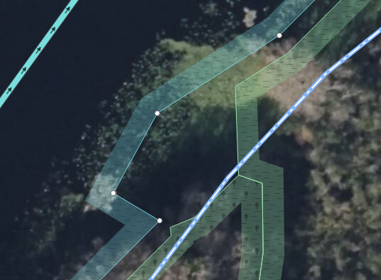
This is an example object, which I chose not to delete before importing the landuse data in the area.
as you can see, the geometry gets a little strange due to the preservation of the object. I chose to preserve this one because I had issues in the area with the import failing to preserve certain retention basins in residential developments.
All the examples you listed were the measured risk that I chose using my method of conflation. The first two examples of the water areas and wood were deleted with the incorrect assumption that the import would have a replacement object in the area. The eight wastewater ponds were deleted with the assumption that the import would have a correct replacement with less awkward geometry. This was the risk that I chose in these deletions, knowing that in some cases like these it was possible that there would be an inadequate replacement.
The river issue was one of the hardest things to address in the import. all the data files are split on county lines, which becomes problematic when a river splits 2 counties as you showed. The solution I normally tried was preserving any existing river geometry, so that all the county and bridge splitting issues didn’t occur. In some cases, little or no geometry exists, and I choose to include the water area, just split on the county line.
In this particular case, it appears that I made 2 mistakes, deleting the existing water object, (likely due to its size) as well as not importing the water body on the other half of the county line.
The deletion of this water body was accidental, I delete water bodies by searching in an overpass download of the county for natural=water name= and combing through the results to remove any water bodies from the selection I don’t wish to delete. I failed to remove this valid water object from the selection, and ended up accidentally deleting it.
The second error resulted from the way that I review objects in my conflated file. I go through and delete any small river areas that were not cut out when I cut out the water body from OSM, due to the OSM data not being entirely accurate to the area of the water part of the river. It prevents the creation of any tiny isolated water body pockets (see image)
I deleted the other half of the linked river because I incorrectly identified it as one of these isolated water pockets.
27.69652 -82.34274
I couldn’t come up with an acceptable solution to the bridge problem, and I was not able to address it.
These choices, while resulting in small errors in certain areas, saved hundreds of hours of labor over the entire import. This is the reason these errors exist.
-James


