You might want to update the US ranking ![]()
I wonder why Schneefernerkopf doesn’t appear in the list? The tagging looks correct to me. Could it be because it is on the country border and not assigned to either country?
Nice. Are you going to update it regulary?
Could also be on the Austria list, just not in the top 100.
1 Like
But how do you know what the right answer is?
Alternatively they can be given in feet (e.g. ele=450 ft, ele=450feet)
It would also be worth capturing elevations in feet if they are listed with a typewriter apostrophe character after the feet value (e.g., ele=450’) as this is the documented way of expressing height, width etc in feet.
(See RFC: Documenting feet as an an optional elevation unit)
2 Likes
Just some observations.
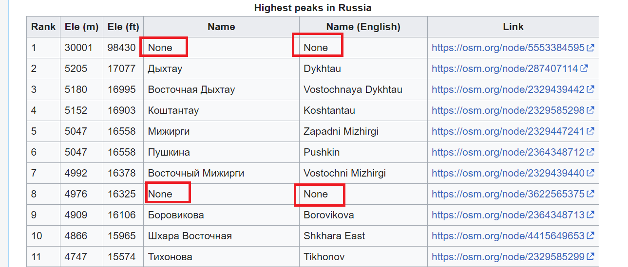
- Elbrus, the highest mountain in Russia and Europe is missing. It is present in OSM however.
- 'None’s should rather be just blank.
- Links to wikipedia/wikidata from the corresponding osm-tags could be beneficial.
For validation, you can compare ele values from osm with wikidata. ![]() Also, high peaks without wikipedia/wikidata tags are most probably mistakes.
Also, high peaks without wikipedia/wikidata tags are most probably mistakes.
I have updated the list with data from 22 January. That’s before I made this post, so any changes since then will not yet be reflected in the data.
I am working off the weekly planet files, so unfortunately there is some delay. I will try to update the list semi-regularly, as long as there is demand.
Thanks all for your comments. The new version of the list
- accepts an apostrophe as the unit for feet
- correctly handles mountains on the border (such as Schneefernerkopf) as part of both countries
- includes
natural=volcanoin addition tonatural=peak, this is why Elbrus was missing - prints (none) instead of None. I prefer this to a blank cell because you can use Ctrl+F to search and highlight missing values
- includes Wikipedia and Wikidata links
I’ve noticed Mount Everest appears in the list for Nepal but not for China. This is because the peak node is actually in Nepal, 1cm or so from the border. A mistake?
Assuming that the contour lines in our topographic maps are correct, it’s possible to spot some obvious mistakes: some are off by a factor of 10, others have the elevation in feet instead of metres and no unit.
Of course, the usual caveats apply, we can only use sources with a compatible licence, etc. Also, often other lists of the highest mountains ignore subsidiary peaks which will show up on this list.
The list may also be useful to spot mountains that are missing a name tag, or have a name tag in a language unusual for the country (e.g. when name has the English name, not the local one). And now it can be used to spot important peaks that are missing wikidata and wikipedia tags too!
4 Likes
This sounds like job for Sophox. The following query will output a list of peaks in Germany where OSM and Wikidata have a different elevation:
Query
SELECT DISTINCT ?peak ?peakLabel ?osmElevation ?wikidataElevation
WHERE {
  ?peak osmt:wikidata ?wikidataId.
  ?peak osmt:ele ?osmElevation.
  ?peak osmt:name ?peakLabel.
  ?peak osmt:natural "peak".
  SERVICE <https://query.wikidata.org/sparql> {
    ?wikidataId wdt:P17 wd:Q183.
    ?wikidataId wdt:P2044 ?wikidataElevation.
  }
  FILTER (
    xsd:float(?osmElevation) != xsd:float(?wikidataElevation) &&
    ABS(xsd:float(?osmElevation) - xsd:float(?wikidataElevation)) / xsd:float(?wikidataElevation) > 0.01  &&
    ABS(xsd:float(?osmElevation) - xsd:float(?wikidataElevation)) > 5
  )
}
ORDER BY DESC(ABS(xsd:float(?osmElevation) - xsd:float(?wikidataElevation)))
It only outputs peaks where the difference is over 5 metres, and over 1%.
Q183 is Germany and can be replaced by the Wikidata ID of a different country. It doesn’t do any unit conversions so won’t work if the elevation in OSM is in metres and the one in Wikidata is in feet (seems to be quite common).
I made this with ChatGPT and I was rather surprised how well it worked. It’s probably possible to get it to do the unit conversions too.
I’ve looked at a few peaks in Germany and didn’t see any where OSM obviously had the wrong elevation. Either Wikidata was obviously wrong or OSM had the wrong Wikidata tag because two mountains have the same name.
1 Like
That there may be an issue with the mapping of a 30001m / 98430’ tall mountain? ![]()
![]()
This example SPARQL query converts between currency values in Wikidata. Currencies are modeled as units, so the same approach can convert whatever unit of measurement is specified for an elevation.
2 Likes
Hello
It’s indeed a good process.
However we’d better using common QA tools to achieve such comparison and take advantage of using (and continuously improving) the same process on many topics.
Life is way too short to bring this manually instead of automatize and querying wikidata once and for all.
I have updated the list of highest peaks with data from 29 January.
There have been quite a few changes. The following countries have had the most:
| Country | No. of changes |
|---|---|
| Papua New Guinea | 11 |
| United States | 10 |
| Vietnam | 10 |
| Bhutan | 4 |
| Chile | 4 |
| Uganda | 4 |
| Argentina | 3 |
| Eritrea | 2 |
| Moldova | 3 |
| Turkey | 2 |
Edit: corrected list after finding a bug in my code
2 Likes
List updated with data from 5 February. There have been a few changes, so I’ll keep updating as long as there is activity.
I also fixed a bug where if two peaks had the same elevation, only one would be shown.
| Country | No. of changes |
|---|---|
| Bhutan | 4 |
| Libya | 1 |
| Madagascar | 1 |
| Montenegro | 1 |
We can integrate this into QA tools, if we spot systematic issues, in the meantime it takes me maybe one minute to update the list every week, if you don’t count the time it takes to download the data and run the calculations, so I don’t mind doing it if people find it helpful.
From manually reviewing the data we can then spot the sort of systematic issues that could be integrated into QA tools. So far we know of cases of
- OSM having blatantly wrong elevation e.g. in some cases off by a factor of 10 or in feet instead of metres (with no unit given)
- OSM having slightly wrong elevation e.g. off by a metre or two
- OSM having the wrong Wikidata tag
- Wikidata having the wrong elevation
- peaks missing names in the local language
- peaks missing Wikidata
Some of these are more suited for automated QA than others. For peaks (or other items) missing Wikidata, https://map.osm.wikidata.link already exists and it works really well.
2 Likes
List updated with data from 12 February. I raise my hat to the mappers from / in Uruguay, where 50 new peaks have been added to OpenStreetMap!
| Country | No. of changes |
|---|---|
| Uruguay | 50 |
| Kazakhstan | 20 |
| Vietnam | 19 |
| Canada | 17 |
| Cyprus | 11 |
| Yemen | 8 |
| Bhutan | 4 |
| Ukraine | 2 |
| United Arab Emirates | 2 |
5 Likes
List updated with data from 19 February, this weeks Yemen takes the crown ![]()
| Country | No. of changes |
|---|---|
| Yemen | 66 |
| Egypt | 16 |
| United Arab Emirates | 9 |
| Vietnam | 8 |
| Uruguay | 3 |
| Albania | 2 |
| Cyprus | 2 |
| Czechia | 2 |
| Tunisia | 2 |
4 Likes
List updated with data from 26 February. Again many changes in Yemen.
| Country | No. of changes |
|---|---|
| Yemen | 22 |
| Dominican Republic | 7 |
| Vietnam | 5 |
| Bhutan | 4 |
| France | 3 |
| Malaysia | 3 |
| United Arab Emirates | 3 |
2 Likes
List updated with data from 4 March.
Top countries this week:
| Country | No. of changes |
|---|---|
| United Arab Emirates | 9 |
| Singapore | 8 |
| Bhutan | 4 |
| Yemen | 3 |
| Vietnam | 2 |
| (23 countries with one change not shown) |
2 Likes
Data from 11 March. The tectonic plates just won’t stop moving!
Top countries this week:
| Country | No. of changes |
|---|---|
| Yemen | 17 |
| Malaysia | 5 |
| Vietnam | 5 |
| Oman | 4 |
| United Arab Emirates | 4 |
| Kazakhstan | 3 |
| Myanmar | 3 |
| Cyprus | 2 |
2 Likes
The thought has crossed my mind to use the OpenTopoMap gradients to enter quite a few missing ele values for named ‘peaks’ in the local
Apennine range (often just named bulges in the mountain area’s) and add source:ele=estimated. OTM shows gradients for every 10 meter change, close enough I’d think, it’s not like getting it exact on K2. That said, hikers today walk around with GPS so know how high they are and where on the map. Someone went about and map ‘peaks’ named after villages, or the other way around, such as Colle Marcone and Colle Rotondo i.e. you find the same name twice on the map in close proximity. Osmose keeps nagging for an elevation value.
Searching longer for altitudes for particular significant peaks on the www has mostly hit not. CAI (Club Alpino Italia) has a huge membership. There’s a dieterdreist-CAI account (no forum account), the same person as the italian moderator. Maybe he’s got an inroad to get things in movement or ‘peak’ the interest.
At any rate, don’t think any of the high points without an ele value will be in the top 100.