I wonder why Schneefernerkopf doesn’t appear in the list? The tagging looks correct to me. Could it be because it is on the country border and not assigned to either country?
Alternatively they can be given in feet (e.g. ele=450 ft, ele=450feet)
It would also be worth capturing elevations in feet if they are listed with a typewriter apostrophe character after the feet value (e.g., ele=450’) as this is the documented way of expressing height, width etc in feet.
I have updated the list with data from 22 January. That’s before I made this post, so any changes since then will not yet be reflected in the data.
I am working off the weekly planet files, so unfortunately there is some delay. I will try to update the list semi-regularly, as long as there is demand.
Thanks all for your comments. The new version of the list
accepts an apostrophe as the unit for feet
correctly handles mountains on the border (such as Schneefernerkopf) as part of both countries
includes natural=volcano in addition to natural=peak, this is why Elbrus was missing
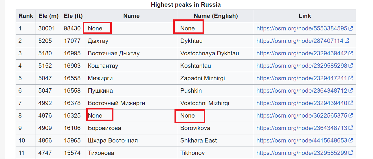
prints (none) instead of None. I prefer this to a blank cell because you can use Ctrl+F to search and highlight missing values
includes Wikipedia and Wikidata links
I’ve noticed Mount Everest appears in the list for Nepal but not for China. This is because the peak node is actually in Nepal, 1cm or so from the border. A mistake?
Assuming that the contour lines in our topographic maps are correct, it’s possible to spot some obvious mistakes: some are off by a factor of 10, others have the elevation in feet instead of metres and no unit.
Of course, the usual caveats apply, we can only use sources with a compatible licence, etc. Also, often other lists of the highest mountains ignore subsidiary peaks which will show up on this list.
The list may also be useful to spot mountains that are missing a name tag, or have a name tag in a language unusual for the country (e.g. when name has the English name, not the local one). And now it can be used to spot important peaks that are missing wikidata and wikipedia tags too!
It only outputs peaks where the difference is over 5 metres, and over 1%.
Q183 is Germany and can be replaced by the Wikidata ID of a different country. It doesn’t do any unit conversions so won’t work if the elevation in OSM is in metres and the one in Wikidata is in feet (seems to be quite common).
I made this with ChatGPT and I was rather surprised how well it worked. It’s probably possible to get it to do the unit conversions too.
I’ve looked at a few peaks in Germany and didn’t see any where OSM obviously had the wrong elevation. Either Wikidata was obviously wrong or OSM had the wrong Wikidata tag because two mountains have the same name.
This example SPARQL query converts between currency values in Wikidata. Currencies are modeled as units, so the same approach can convert whatever unit of measurement is specified for an elevation.
It’s indeed a good process.
However we’d better using common QA tools to achieve such comparison and take advantage of using (and continuously improving) the same process on many topics.
Life is way too short to bring this manually instead of automatize and querying wikidata once and for all.
List updated with data from 5 February. There have been a few changes, so I’ll keep updating as long as there is activity.
I also fixed a bug where if two peaks had the same elevation, only one would be shown.
Country
No. of changes
Bhutan
4
Libya
1
Madagascar
1
Montenegro
1
We can integrate this into QA tools, if we spot systematic issues, in the meantime it takes me maybe one minute to update the list every week, if you don’t count the time it takes to download the data and run the calculations, so I don’t mind doing it if people find it helpful.
From manually reviewing the data we can then spot the sort of systematic issues that could be integrated into QA tools. So far we know of cases of
OSM having blatantly wrong elevation e.g. in some cases off by a factor of 10 or in feet instead of metres (with no unit given)
OSM having slightly wrong elevation e.g. off by a metre or two
OSM having the wrong Wikidata tag
Wikidata having the wrong elevation
peaks missing names in the local language
peaks missing Wikidata
Some of these are more suited for automated QA than others. For peaks (or other items) missing Wikidata, https://map.osm.wikidata.link already exists and it works really well.