In Brisbane, residential areas are often drawn as individual little areas around each block of houses, excluding any road. As not all areas are covered, the result is a checkerboard whilst the actual builtup area is much larger. What is common practice and advised ?
Really, there is none!
Some people do as you say, tracing out exact blocks of houses between streets; other have islands separated by primary / secondary roads; while other have the entire town as one residential area.
Really, it’s up to the person mapping, unless there’s been some sort of local agreement that we’re going to do it “this” way.
Have fun! ![]()
4 Likes
What is common practice and advised ?
while there isn’t a clear answer to this question, it is IMHO preferable to exclude the roads from the residential landuse. Roads are a landuse on their own.
One can always reduce detail by automatically merging same kind landuse and filling small gaps between them, but when huge areas are approximately mapped with a single residential landuse, these will slowly or never be refined with more detailed landuse, and when they are, the result will often be unmanageable multipolygon relations. Missing details cannot be automatically filled in, there is typically less information available when the landuse is mapped only roughly
5 Likes
Is this an argument for not mapping landuse=residential at all? If we say that residential roads are a landuse on their own, doesn’t the same apply to houses, apartment blocks, car parking, driveways, and gardens? If we map everything in detail, what does that leave to be mapped as landuse=residential?
2 Likes
I would only cut a residential area in two if, when you’re there, it “feels like” you are crossing into a different residential area. This means I’d do it at larger roads, not at every residential road - and my argument is similar to dieterdreist’s just the other way round, if someone desperately wants roads cut out of their residential area then can do that easily in a data processing step - no need for mappers to endlessly complicate residential area mapping by creating micro-residentials that end at every road. Where will it end? Driveways being cut out of residential areas? No thanks.
14 Likes
There are three distinct different ways of mapping landuse=residential:
The first would be to see landuse=residential more as the full built-up area. So, to have one landuse=residential for an entire city. All other landuses like commercial are placed on top of this landuse=residential. This is seen as a rougher technique that was used to quickly fill in the landuses.
Example: https://www.openstreetmap.org/way/8043936
The second method is mapping landuse=residential more as blocks where you split the landuse=residential on all major roads, railways, and waterways etc. but not necessarily highway=residential. This has the advantage of preventing overlaying landuses and prevents the one landuse=residential from being edited too much.
The philosophy of this method sees landuse more as areas that include the streets to do its function.
Example: Way: 313052849 | OpenStreetMap
The last method is mapping landuse=residential as the precise area of the lived area. For example, taking the garden + buildings as the outline of the residential area. This has the advantage of having more precise specification of smaller landuses like landuse=education/garages/religious.
The philosophy of this method sees landuse more as the function of parcel or the function of an exact square meter instead of the rough function of an area.
Example: Way: 1108275247 | OpenStreetMap
Generally, there is not a best method, all the methods have advantages and disadvantages, and it also depends on the area what works the best.
3 Likes
It is of note that Osmose when first implementing the flagging of ways crossing areas, secondary and tertiary were marked as well inviting the mapper to split the area along these ways cutting thru. Of recent that flagging has been reduced to primary road and above, describing the alert as “Bad intersection with MAJOR highway…”, major my emphasis, which is agreeable to me.
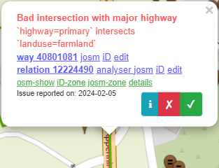
When cutting thru residential the primary roads are not flagged either i.e. left up to the mapper’s choice. I do for these, but that’s where I mostly draw the line. It’s kind of what the available mapping space is and what else needs fitting in, sidewalk, paths, cycleways, tree rows, grass fringes, street side parking etc.
I would not think so? Not only “residential” roads are a landuse on their own, all public roads are a landuse on their own. “houses”, “apartment blocks”, “driveways”, “gardens” are all on plots used for residential purposes, aren’t they? How should they not fit under the “residential” use?
1 Like
(Hi from The Netherlands) In Brisbane the last method tends to be used. Main disadvantage I see is that it results in a checkerboard pattern of individual parcel groups being either ‘done’ or not. The term ‘landuse’ also suggests a more broad concept than a single individual block and a residential road is by the name part of a residential area.
I say they cannot. Consumers could at most estimate a road width and sidewalk widths and assume that adjacent properties start right beyond the sidewalk, but there will be lots of situations where you would not get it right with these heuristics. I believe part of the dispute is about the term “residential area”, or “residential landuse”, the former can be seen as a part of a settlement, a quarter or neighbourhood with predominating residential use, and it could also be seen as an area with predominant residential use (but on a different scale, block related). The terms used in the wiki to describe what “landuse” means are approximate and allow for both kind of interpretations. Landuse refinement in many areas somehow stopped at the detail level of 2007, where many motorways in my country still had a oneway=no tag because a single way represented both directions. People do not use “landuse” for routing, and there are buildings for detailed city mapping, so even if the landuse if completely off, it doesn’t matter to many usecases, that’s why we still are where we are.
I believe it is more complicated to do reasonable generalization (and generalization always has to reflect the scale for which it is intended, so in the context of OSM it seems inherently impossible to do it well) than it is to simply map what is there (i.e. landuse polygons for those areas where the landuse actually is. Nobody lives in a church, a kindergarten, in a lake, in a public park, in a school, on a public square or similar (or maybe someone exceptionally does, but it is not the dominant use). For the mapper, it is more complicated to continue the currently still predominant style than it is to give more information by being more detailed. It also helps to prevent errors by connecting roads to landuse polygons, when the landuse polygons don’t cross the highways.
I agree that driveways should not cut out of residential areas, and I have not seen such suggestion, nor would it be logical with even more detailed landuse mapping, because these driveways are seen as part of the residential property, unlike the public road.
Anyway, we are moving, very slowly but I can notice it is happening, towards a more detailed landuse mapping of built up areas, so inevitably we will sooner or later arrive at (potentially, where necessary) plot-sized detail level.
There is no strict rule. Drawing larger areas and include the area of reads inbetween is perfectly okay.
I do aswell typically exclude roads, sidewalks, cycleways etc as i guess in a couple of years we will also map areas for “mobility” as seperate landuses. There have been a lot of experiments with making highway areas (additionally to the line needed for routing).
So one could envision a world where we have landuses for highways, and then a tagging scheme for the broken down individual spaces for pedestrians, kerbs, cycleway, carriageways etc.
So excluding them now may be the way forward. But i wouldnt remap everything to do so, neither would i grow the existing landuses.
Be relaxed.
Flo
I use all three, but I usually leave the residentials mapped by others alone.
I never see other data use of residential areas than the “residential” colouring on maps. I can think of other uses, but are there actual implementations?
Recently discussed in Croatian community:
The original poster, @Vedran_V, complained about someone’s “patchy” mapping style which complicated his analysis, although he did not specify the exact use case. Perhaps he could clarify.
Mapping exact landuses, encourages more fine-grained specification. Especially when the type of landuse is generally small like religious and education landuses.
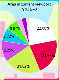
On the landuse and landcover map you can get more precise numbers on the specific landuse percentages.
https://osmlanduse.org/#16.6203084096217/5.79579/53.21554/0/

1 Like
I don’t see that including residential roads in residential landuse prevents this, area:highway or whatever tags are settled on can still be used. Just as we can have detailed mapping of buildings within a landuse polygon, can’t we also have detailed mapping of road areas?
2 Likes
I politely disagree with this and see streets in residential areas as part of landuse=residential. There’s no benefit to turning OSM into a pseudo-parcel map. Mapping landuse as zoning is more practical.
Also, roads are not landuse areas IMO. Roads are roads, and there’s no benefit to mapping them a second time with landuse tags.
9 Likes
The whole point of landuse residential is to provide a generalised indication of the most prominent usage. If you don’t use it for that it doesn’t make any sense at all as all the other bits are aera:highway, leisure=garden, building outlines and so on.
7 Likes
|
|
- | - |
I politely disagree with this and see streets in residential areas as part of
landuse=residential. There’s no benefit to turning OSM into a pseudo-parcel map. Mapping landuse as zoning is more practical.
I don’t know how zoning maps are drawn and at which scale, and whether there are different scales involved, but I know from Germany that landuse is done on parcels (the authorities prescribe landuse at least at parcel granularity but ocassionally also finer grained) hence when we go out surveying, we find the reflection of these prescriptions.
Also, roads are not landuse areas IMO. Roads are roads, and there’s no benefit to mapping them a second time with landuse tags.
then you should not include them (if they are not considered “landuse” in your book). I agree that drawing them is not what seems most appealing to do with my time either, so I consider them implicit (what also can be done with roads drawn as lines, but is more approximate as having the border explicitly drawn, but the legal road areas omitted)
A variant of one of these methods draws the landuse area to correspond to a coherent planned development, with the name of this development in name. This isn’t quite the same as mapping a place or boundary; rather, it’s an alternative way to indicate a built-up area’s structure based on planned developments.
For better or worse, this style departs somewhat from the classical concept of land use in urban planning. But at this point, if we must map an apartment complex as a coherent landuse=residential residential=apartments and a mobile home park as a coherent landuse=residential residential=trailer_park, then for consistency’s sake, we must also map a housing estate (aka subdivision or master-planned community) as a landuse=residential as well.
The caveat, of course, is that not every region of the world is developed in such a rigid manner.
All this to say that the housing estate obviously includes the public streets that serve (and mostly dead end within) the housing estate. You might have already passed an entrance sign by the time you reach one of these streets. If you want to micromap to the point that each of these streets has a landuse=highway around it and the lush front lawns are blanketed in landuse=grass, by all means please do so. But it doesn’t have to result in cutting up the named residential landuse area, because our data model allows areas to overlap.
3 Likes
this is one part, and the other is preservation and transformation. In Europe at least, it isn’t en vogue any more to just tear down what was there in order to make space for a new development from scratch, the cities, particularly the central areas, are the result of hundreds and sometimes thousands of years of development. Also not rarely, (urban (re)development) plans are not executed completely because halfway the leading ideology changes. When the sixties generally subordinated everything to the requirements of automobilized citizens, these plans have been criticized at least since 1970, initially by some scientists and with some delay the criticism has sometimes been echoed by society and politics. Of course this is not the same everywhere, urban development is generally subject to local culture and traditions, but what is common is that as a result of urban transformations for longer periods of time the landuse is often less homogeneous. What we are mapping with landuse is the current landuse and not the currently prescribed landuse, so even if there is a zoning plan and current zoning seems homogeneous there may sometimes be outliers due to former use (or due to not respecting what is legally prescribed)