As a part of regional transportation agency, we’re currently engaged in a project that involves updating certain attributes of road network data (managed lanes) within OpenStreetMap (OSM). Our goal is to ensure the most accurate and useful representation of our roadways, which benefits both the community and enhances the quality of the datasets we rely on.
We’re setting out to enhance the details of roadways without changing their geometry. Our focus is on areas where the reference names currently lack uniformity. We aim to standardize reference names and update tags for HOV lanes and tollways for better consistency. Our method involves making bulk edits through the OSM API to ensure these attributes are clear and uniform across the board.
Before we begin, we’re keen to ensure that our approach is fully aligned with the community’s guidelines. We’ve done some research on the best practices for bulk updates but haven’t found clear instructions. If there are specific guidelines or considerations for this type of update, we’d be grateful if you could point us in the right direction.
The problem with your project lies in several factors. In Dallas, the roads are owned by the North Texas Transit Authority, while the ones in Austin are owned by someone else, while the ones in Houston are by someone else. They’re gonna call them whatever the higher up of each company decide to call them.
The second thing is going to be how locals refer to something as. I may call a TeXpress lane HOV and all other lanes like the as such. Those from other parts of the country (or even world) may just refer to them as whatever they’re used to.
For a better understanding of the debate, you need to look at the debate about the naming of service roads throughout the state.
Hi, it’s great to see regional transportation agencies like yours take an interest in OSM!
Would you mind elaborating? What are some examples of inconsistencies you’ve found so far? We currently identify routes in a couple ways, so it’s possible that what you’re seeing is a legacy encoding for backwards compatibility rather than what we’d prefer data consumers to use at this point.
I supervise both the user that posted the initial message in this thread and the user that initiated the Changeset referenced in a later message, and am here to provide a little additional context.
First and foremost, we appreciate the community’s feedback as we begin to experiment with OpenStreetMap and learn how to contribute in a way that aligns with community guidelines. The resources provided in this thread have been useful.
The organization referenced in the initial post is the North Central Texas Council of Governments (NCTCOG). Among many other functions, we perform short- and long-range transportation planning for the Dallas-Fort Worth area. As you would imagine, this means we maintain a wealth of information about the region’s transportation system and have a holistic sense of how it fits together. One of my goals for our data is to make it more open and accessible in cases where it is appropriate to do so. We have a significant presence on our agency’s open data portal, and we see OpenStreetMap as another means of disseminating relevant data.
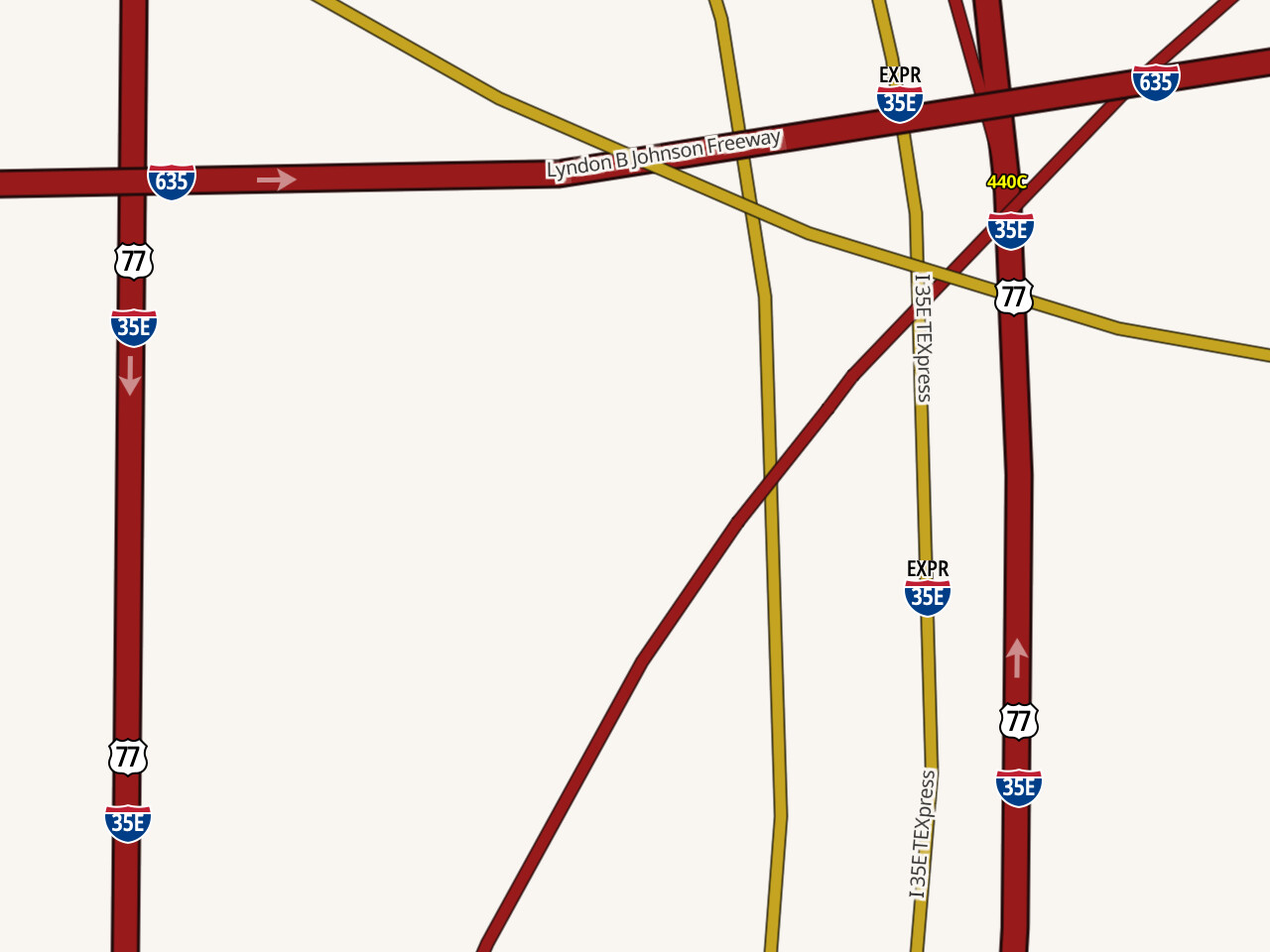
We maintain close working relationships with the North Texas Tollway Authority (NTTA), the Texas Department of Transportation (TxDOT), and the private companies that maintain some roadway facilities in the region through Comprehensive Development Agreements (CDAs). We are aware of how the HOV/Managed/Express lane facilities overseen by these agencies are operated and branded, and see a need to describe these facilities consistently in OpenStreetMap (particularly the Name and Reference Name tags). Examples where we’ve seen issues with names and reference names that are presented to end users in the default OSM interface:
Tolled managed lanes on IH 635 between IH 35E and US 75 in northern Dallas: These were originally described as “I 635 HOV”. While these lanes do offer discounts to HOVs at certain times of day, this does not adequately describe how they are used and is inconsistent with their branding.
Express lanes on US 67 in southern Dallas: This corridor was recently reconstructed, but most of the corridor is still described as “US 67 HOV”. While it retains special-purpose lanes at the center of the facility, the HOV requirement was removed after reconstruction. These are now toll-free “express” lanes with no specific HOV requirements to enter.
Tolled managed lanes on IH 35E between IH 635 and SL 12: Many of these links were described inconsistently, even within the same corridor. We saw ways with names and reference names like “North Stemmons Freeway Expressway” and “35Express” immediately next to or connecting with each other, even in places where there’s no real change in branding or naming of the facility.
Our changes bring consistency to how these facilities are described throughout our region, more accurately describe how some of them are operated today, and reflect the branding and signage used by the agencies that operate them.
Additionally, we have responded to related comments on the Changeset referenced above.
This has been a learning experience for us, and we hope to continue learning more. As mentioned previously, we are new to OpenStreetMap but are eager to contribute the wealth of information we have for our jurisdiction in the spirit of open data.
Thank you for these details – as someone who occasionally maps and uses the map in North Texas, I’d say we’ll take all the help we can get.
I spot-checked @Jonathan_Cupit’s changes and found them to be reasonable in general. A couple notes:
Some of the changesets (example) tagged roadways with toll=Yes or toll=No. The toll=* key should be set to a Boolean value, either yes or no in lowercase. Mainstream editors should already be enforcing these keywords; if your editor is allowing capitalized spellings, that would be a bug.
Name tags should spell out any abbreviations, other than common initialisms like “U.S.” that people normally keep abbreviated. I think name=Interstate Highway 30 HOV would be preferable to I 30 HOV. But also consider that some of these roadways might not have names apart from their route numbers, in which case name=* can be left blank. (noname=yes affirms that the lack of a name is intentional.)
The “TEXpress” branding is important to include in the roadway’s name=*, but the ref=* key on individual roadways is somewhat outmoded tagging convention. These days, we also model routes as route relations. This roadway is part of a “35Express” route relation. The Texas route tagging guide is silent on this kind of highway, but I think the route relation’s network=US:I:Express:Toll tag is consistent with the route markers. For example, OpenStreetMap Americana interprets this tag by marking it with an I-35E Express shield. (It also colors the roadway yellow based on toll=yes.)
Since you’ve taken an interest in ref=* formatting, you may be interested in this discussion about whether the ref=* tags on ways should use a postal abbreviation or align with real-world abbreviations:
I still remember when most Texas state highways were tagged like “SH 12”. I think we could return to that practice, and maybe even TxDOT’s unique “IH” prefix, if enough mappers from the state (including from your team) reach a consensus to do so. Regardless, if the organizations you work with are attempting to consume ref=* from the ways, we’d really encourage you to migrate to route relations. The unstructured ref=* key can’t really accommodate the extreme diversity of route networks in Texas.
I wonder if we are talking about fully separated HOV lanes or are there only some lanes restricted and other lanes on the same road without physical separation less restricted? The latter qualifies for :lanes-tagging (Lanes - OpenStreetMap Wiki) but not for an individual object for the HOV lanes.
Looking at the data, I find highway=constructionaccess=nohov=designated which does look kind of strange.
Pretty much all the HOV and managed lanes in the Dallas–Fort Worth area are fully separated. If I remember correctly, there are a few stretches in Dallas where the HOV lane is separated only by plastic bollards, but that’s close enough to be mapped as separate ways, since only emergency vehicles would ever cross those barriers in practice.
So far, NCTCOG’s edits have only touched the name, ref, and toll keys.
The combination of hov=designated with highway=construction may seem a bit awkward, and could technically be replaced by construction:hov=designated, but I don’t think it’s a problem in practice. A router isn’t going to route over a road under construction just because of access tags, since it has already omitted these roads when building the routing graph. For the same reason, highway=footwayaccess=permissive isn’t going to cause a router to send cars down the walkway.