Da habe ich jetzt keine Quelle. Ich sehe aber auch nicht, wo steht, dass das verboten ist. Wenn dem so wäre, dann könnten selbst KFZ aus vielen (entsprechend freigegebenen) Fußgängerzonen nicht legal ausfahren, da dies nur über Fußgängerampeln geht und für den ausfahrenden Fahrverkehr keine Ampeln existieren.
O.k. da steht jetzt aber auch nicht, dass ich diesen Übergang überhaupt benutzen darf. Habt ihr dazu Quellen? Ich konnte dazu nichts finden.
zumindest abseits von Fußgängerüberwegen kannst du mit dem Fahrrad die Straßenseite wechseln, (sofern die Mittellinie nicht durchgezogen ist, sonst musst du schieben) nennt sich Wenden.
Soweit ich es nicht übersehen habe ist das Wenden an Fußgängerüberwegen und im Ampelbereich nicht verboten.
Aber du hast natürlich keine Vorfahrt sondern musst alle anderen zuerst durchlassen
Diese Tags sind aber uralt, das kann man kaum vergleichen. Die Ergänzung im Wiki zu unserem Problem ist von 2020.
bicycle=no wurde wohl im Frühjahr 2008 abgestimmt
Also ich finde nur die bereits verlinkte Abstimmung zu highway=crossing, aber keine zu highway=traffic_signals. Erleuchte mich mal ![]()
Kleine Statistik:
Aktuell gibt es noch 183 Fälle in Deutschland.
hw=traffic_signals mit bicycle=no.
Niederlande: 1 Fall, aber an einer Straße die ebenfalls bicycle=no hat.
Die Beschilderung ist flasch …
Das Zusatzzeichen gehört über das 205
Wenn im anderen Bildbsp. mit der Radfurt neben dem Zebra die Radfurt fehlt, ändert das nix am Vorrang des Radlers, weil er, im Kreisel kreiselnd, eh Vorrang hat.
1 Like
So ist es.
Oder Querungen nur mit Fußgängerampel, auf die auch Radwegweiser weisen:
https://wiki.openstreetmap.org/wiki/User:MitteloberrheinischerWaldameisenschreck/Streuscheibenfrage
1 Like
Urks. Ich ging bisher davon aus, dass es früher nur highway=traffic_signals gab und das Proposal vorschlägt, das in highway=crossing mit crossing=traffic_signals aufzudröseln, aber so langsam verstehe ich.
Dann nehme ich alles zurück und behaupte das Gegenteil. Das Tagging ist korrekt und die Router sind kaputt. Hilft leider auch nicht viel. Dann mache ich mich mal ans Flicken in der Gegend.
Interesting find that archived proposal, I did not find any enthusiasm for highway=crossing + bicycle=no, maybe except for @Mateusz_Konieczny, before this find and think that is still the case after this find.
My take on adding bicycle=yes/no on higway=crossing is that is it useless tagging, the fact that everybody seems to agree that routers should ignore this access tag for highway=crossing is also pointing in that direction.
Also that “solitary” crossing case is to my opinion useless tagging but let me react on that in a separate reply.
I would be happy just removing all bicycle=* for highway=crossing, starting with bicycle=no  That is also what I do not like about the Wiki, it is actively encouraging people to add bicycle=*, I think it should not mention it or indicate it is better not to tag it.
What I also see is that there is some strange drive to add “useless” bicycle related tagging to all kind of objects, for example for ~2.5% of highway=footway there is bicycle=no/dismount, that is even higher than the ~0.25% for highway=crossing.
On the ~2.5% of highway=footway with bicycle=no/dismount
The default access restrictions, indicate bicycle=no for highway=footway and all countries except for Iceland, Norway, Belarus/Russia? have either bicycle=no or bicycle=dismount.
Given this, it is likely better to satisfy this strange desire and come up with an alternative tagging scheme that also clearly defines what this exactly means.
I think the only way to solve this properly is by using namespaces to describe the individual parts of a crossing. A highway=crossing is, by default, a pedestrian-only crossing. Every other detail always refers to this crossing. So the crossing=unmarked describes an unmarked pedestrian crossing, it doesn’t say anything about markings for bicycles. I’m suggesting to use cycleway: and bicycle: namespace to add these details:
bicycle:crossing=traffic_signalsto declare that there are traffic signals for bicycles (either separate ones, or those for the pedestrians need to be used) which also implies that bicycles can cross the road. The opposite would bebicycle:crossing=noand of coursebicycle:crossing=uncontrolledwhen bicycles have road markings.cycleway:crossing=yes/noto indicate that the pedestrian crossing is not crossing the cycleway running along the street.cycleway:traffic_signals=yes/noto indicate whether the pedestrian crossing also crosses the cycleway with traffic signals (the default is probably different in each country).
I’m not 100% sure whether this is the right tagging. The main idea is to use cycleway: to describe the pedestrian-crossing from the perspective of the cycleway parallel to the road, and bicycle: to describe whether and how bicycles can potentially cross the road. The benefit is that this would also allow us to tag whether the cycleway has to stop for pedestrians crossing as well, which is currently also not possible. Of course, one could also use crossing:bicycle: instead of bicycle:crossing, I’m just throwing some thoughts in here how to map this without breaking any routers.
2 Likes
Auch lustig:
der Weg hat bicycle=yes, aber der crossing-Node hat bicycle=no… 
(Als screenshot, da bereits gefixt)
1 Like
I think this would be the better alternative, grouping the properties of the crossing under the same namespace
Why you consider useless to map places where cycleway is interrupted by crossing where cyclist are legally obligated to stop and walk through crossing?
How you would mark ways with full ban on bicycles?
" This page documents what some mappers consider to be correct fallback behavior in a routing engine and could be considered a proposed specification. However, no mainstream routing engine uses this page directly to influence routing behavior."
" The developer of a routing engine used by multiple apps pointed out that the concept described in the tables below creates confusion by mixing two independent questions:
- what is the legal access if an OSM way has no access tags ?
- what is the legal access if a (real world) way is not signposted ?"
This page should not be treated too seriously as it is fatally flawed. I will add note specifically about Poland and bicycle access on footways.
Wenn ich mir die Streuscheibe so ansehe, dann erkenne ich da nur einen Fußgänger und kein Fahrrad, also war das bicycle=no wohl richtig.
1 Like
das wiki ist sich ja selber nicht sicher, was bicycle=no überhaupt bedeutet, zuerst steht da, “to tag whether the crossing is also a cycleway crossing used by bicycles.”, und weiter hinten steht dann, es gehe darum, ob das Queren mit dem Fahrrad “legal” sei ("[bicycle](https://wiki.openstreetmap.org/wiki/Key:bicycle)=[no](https://wiki.openstreetmap.org/wiki/Tag:bicycle%3Dno) - useful in case of cycling being legal at sidewalk but not while crossing road"). Es könnte ja aber sein, dass es sich zwar nicht um eine Straßenquerung des Fahrradwegs handelt, und dass das Queren per Rad dort trotzdem legal ist. Haarspalterisch wäre es wohl zu fragen, wie man die Straßenquerung eines Fahrradwegs taggen soll, wenn Fahrräder sie effektiv nicht benutzen (was ich meine: wieso ist da ein “und der von Fahrrädern benutzt wird”, macht das denn einen Unterschied? Mit dem “und” muss es ja immer ein Fahrradweg sein).
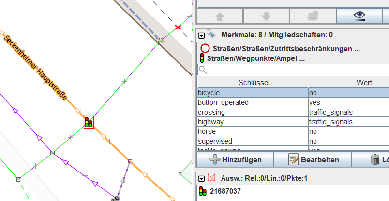
Seckenheim:
Danke für’s nachforschen. Werde es dann zu crossing:bicycle=no ändern.
Den querenden Weg kann ich da auf dem mapillary Foto gar nicht erkennen.
Ich vermute dass der direkt zur Einmündung Uhldinger Str führt.
I assume you mean in this case that there is no crossing highway=footway/pedestrain/cycleway/path mapped in OpenStreetMap and this is what I call a “solitary crossing”.

So you say one can switch here from one side of the road to the other side. Then my question is to show me a router (or user) that takes into account the side of the road for the start or destination. If you have found the router[^1] then let’s hope OpenStreetMap has all crossings mapped so you do not have to walk/cycle kilometers to make the turn to start walking/cycling in the right direction.
For “normal countries” which do not have jaywalking forbidden people can also cross the street on most places or everywhere.
This was already discussed in the brouter issue, look for “But the cycleway is not formally crossing the street.”.
If you want to micro-map these things then map what is on the ground in detail, so map the crossing itself as separate way and give the crossing way whatever access tags you think are appropriate. If you map the crossing way as highway=footway you can consider adding footway=crossing
I hope (and think) this type of construction is not too common, it is far from cycling-friendly.
To complete the picture on usefulness let me also describe “non-solitary” crossings here:

Here the access rights on the ways are more then sufficient to map out the access for the crossing, no additional tags on the crossing itself are needed. It is also more flexible, all for legs can have different access rights if you want.
Does anybody still have a (obscure) use case that gives some usefulness to highway=crossing + cycleway=*, I like to hear.
[^1] I would be surprised if you can find such a router as it is c
ommonly agreed that router should ignore bicycle=yes/no and you added that text to the highway=crossing Wiki)
I agree with you that this would be best for micro-mapping things, like the case where the cyclist are legally obligated to stop and walk through crossing. footway=crossing and cycleway=crossing are well established.
I still fear that there will be the desire to tag the highway=crossing node itself, although I think it is useless but explaining that is not that simple.
Given that I think what can be tagged (map what is on the ground) are markers and that I think is a property of the crossing, so I would think of crossing:bicycle. It should be completely ignored by routers and users.
I agree and that was my exact reason for being interested in mapping them.
If highway=cycleway crosses road where crossing has crossing:bicycle=no then additional penalty should be applied to this route (assuming perfect router)
If routers are ignoring sides of road for routing then it will result in substandard routing in many cases (yes, I am aware than routers are often far from perfect - but it should be at least possible to specify such data, even if it is currently not used)
Sadly many people live in places where law is pedestrian-hostile and mapping of detail relevant there is perfectly fine.
Please do not try to get rid of tagging just because it is useless in your area.
I am 100% fine with deprecation and specifying crossing:bicycle=no as replacement, I would also consider is it possible/useful to have deprecation rules in iD, JOSM and StreetComplete quest.
And I do not see need for proposal. Just discussion here or or on tagging without anyone declaring opposition. Just title it clearly that it proposed deprecation of highway=crossing bicycle=no combination.
Though if there will be some opposition then making a proposal would be better.
1 Like