An 18-sided fence sports pitch

Today our task is to make an 18-sided fenced sports pitch.

Simple. Draw a closed way, and then add the tags

  • leisure=pitch
  • sport=…ball
  • barrier=fence

But no. According to the wiki, the fence must be a separate object.

Okay now we have to draw the perimeter all over again.

All 18 corners, a second time.

But as we see in high magnification in various anonymous editors it’s rather hard to make all 18 corners match.

So I say forget about even trying.

And we didn’t use area=yes, nor area=no, so who’s to say whose polygon is it in the first place?

Oh sure, we can just copy the polygon and then try to paste it in the same spot (super hard, plus now 36 nodes (a waste) instead of 18} but that’s even a bigger mess.

https://wiki.openstreetmap.org/wiki/Tag:barrier%3Dfence

https://wiki.openstreetmap.org/wiki/Key:area

P. S., It’s not a symmetrical 18-sided figure so forget about any instant tools.

Use an editor that has a “follow line” option? JOSM has that, so does Potlatch.

2 Likes

Thanks but I can’t use J*** because it’s hardwired mouse button mapping messes up my muscle memory when using any other mapping program.

https://wiki.openstreetmap.org/wiki/Potlatch
says Potlatch doesn’t run reliably on Linux.

Anyway my three tag solution even works on a cellphone!

Make the fence an object, area=no and the pitch a multi-polygon with one element.

Or it you want to avoid using the area=no or single element multi-polygons then do it as two fences and make them a multi-polygon together.

2 Likes

The iD editor also has a “follow line” function.

4 Likes

Is this Vespucci? That app has a setting that allow the user to follow along a line, just by tapping near an existing node on an existing line.

If I’m correct and that’s Vespucci, maybe you’ve accidentally disabled that setting.

2 Likes

Thanks - I had a look through the iD documentation (such as it is) and couldn’t find it.

@jidanni It’d be great if you actually tried to help people to help you by explaining a bit about what you’re actually doing. Many of your posts seem to be of the “all software is terrible” variety, yet you have resisted nudges elsewhere to help change that. Unless you can explain in a bit more detail what each individual problem is, more people than currently do will just ignore your comments.

4 Likes
  1. iD has a snap on function:
    click on an existing point when drawing a new line, then the point of the new line snaps onto the existing point (the colour of the point changes from white to grey).

  2. iD has a “follow a line or surface” function:
    draw a minimum of two points as described in point 1. Then press the “F” key. Pressing it once draws the next point of the new line on the already existing line or outline. Pressing and holding draws the next point as long as you keep the “F” key pressed (be careful, this is fast).

However, this does not work if several superimposed points are already connected.

6 Likes

Maybe the real answer is to relax the “one feature, one object” guideline and simply treat this feature as a “fenced sports pitch” (literally what the OP is trying to map)?

What is the benefit of treating the fence as a separate feature?

EDIT

Just ran a quick check, there are over 120,000 leisure areas (parks, playgrounds, sports pitches) in the world that are tagged barrier=fence, so this simplified approach is already widely used.

1 Like

Fences are always linear, so you’re not worrying about whether it should be an area feature or not.

Imagine, however, that it was a hedge - people have mapped “hedge areas” as closed ways and also “linear ways around a field”. When consuming data, each object can only be either an area or a line. It can’t be a bit of both, with some tags applying to one and some to the other (at least, not without a lot of guesswork).

4 Likes

the key fenced=yes was depreciated some years ago

To avoid misunderstandings:

It means one on-the-ground real world feature should be mapped with only one OSM element.
An OSM element should represent a single on-the-ground feature once and only once .

This does not mean that each real otg feature must have its own separate OSM element. Several real features can be described in one OSM element (poi or way), but one and the same real feature should not be described several times with different OSM elements in the database.

It avoids guesswork about whether any additional tags describe the fence, the object surrounded by the fence, or both. It also prevents unexpected results for barrier types which can be mapped as polygons.

I haven’t given up hope yet that OSM is becoming more serious about data quality, so I’d optimistically rephrase that to “still widely used”. :wink: This is certainly one of the things to sort out if we finally manage to introduce a polygon datatype to the OSM data model.

6 Likes

First we need to be flexible. The fence might only be on 16 sides of the 18-sided sports pitch. Thus fenced_sports_pitch is bad.

Regarding those Follow functions, I’m sure they are great. Except we would need to click 18 times for making our sports pitch, and then 18 more times for making our fence. No? I mean even if we didn’t have to click exactly in the right spot but we still have to click all the same. (I didn’t test it because my computer is in the shop.)

And then about the snap mode. Well I used it. But for some reason when I blow up the map to the extent you see in the picture I found it didn’t actually snap always.

You just can’t trust it. Or, you might say its opinion of what is closest different than my opinion.

And why I’m not actually naming any editors, is because I want to keep this question general. In fact I don’t really have an 18 sided nerfball sports pitch in the first place, but let’s just pretend I did!

And about that multi-polygon stuff. Well, that is rather advanced…

Maybe editor programs should say, “It seems you loaded more stuff than should be loaded on this particular object. Would you like me to make it into two objects?”

And then later let’s say we want to change the geometry of both objects at the same time. Well then we can simply multi-select them.

1 Like

The F{ollow) key can be held until satisfied the target endpoint has been reached… 16 clicks less and if it was decided at start to go full circle one could close eyes and nod off as then the prog decides that one round is enough.

Oh, there"s the N key too which makes a selected node connect to the nearest line, which has to be near, a forced snap so to speak.

Now we mosey off into TGIF mode.

Ciao

1 Like

Okay, but all these “recreating the geometry a second time by pacing around the border” solutions, no matter how automated, just don’t scale up.

Think about when you need to make a fence around a whole forest preserve, national park, or country.

Sure, you might say, “Well they never put a fence exactly on an international boundary. There is always a setback. (Thus you are going to have to edit it manually anyway.)” Well let’s just say they did! So now you’ve got a very long international boundary with many little turns and stuff and how are you going to deal with that in your tiny editor window?

Even one fenced military base with boundaries following curvy ridgelines would have you screaming that you’ve had enough.

It seems all that would be needed is a simple new editor function. For some reason not yet available in any editor.

The function would be very similar to simply copying a way.

Currently every editor has a way to copy a way. Okay let’s see how it’s done currently.: First we make the copy.

Okay, and now we change the tags of our copy. From military base to fence. We also remove any area=yes in our copy.

But then comes the problem of where you’re going to plunk down your new way?

Okay let’s say with your extremely steady hand, you could plunk it down right in the exact place where the old way was.

(Actually in most editors of course you must first plunk it down (paste it) before you can change the tags. Same difference.)

So far so good. Except now we have double the nodes that we actually needed in the first place. In other words we have made 3,000 new nodes instead of reusing the original 3000 nodes of the military base.

Okay let’s take a break and start all over.

What we want to end up with with is an object that in the database looks just like the military base with the exact same list of 3,000 nodes. But instead of saying military base it would say fence.

The original military base would be unscathed. We’re merely creating a second independent object that however reuses the same nodes.
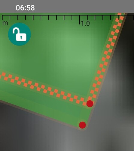
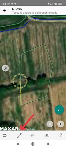
1 Like

https://vespucci.io/help/en/Way%20selected/#select-way-nodes
looks extremely promising. Except I can’t figure out the next steps…

1 Like

Okay, but all these “recreating the geometry a second time by pacing around the border” solutions, no matter how automated, just don’t scale up.

I tend to agree, it may even be easy to create these by hitting the f button on your keyboard, but it will be no fun to detach it when someone wants to add something in between.

There is an alternative, already mentioned: use a multipolygon i.e. reuse the same way to define a linear feature and to define part or whole of a polygon perimeter.

1 Like

Yes, unfortunately.
While similar constructs like bin=yes vs. amenity=waste_basket are still allowed.

1 Like

The “shrinkwrap” available with the JOSM Shrinkwrap plugin can do that for you. Select the military base, press the magic button and you’ll end up with a second closed way sharing the same 3000 nodes.

(That being said, it seems uncommon for an entire national park, military base or other huge facility to be surrounded by an unbroken stretch of identical fence. I believe it’s more typical to see a mix of different fence types, walls, gaps at natural obstacles like rivers or cliffs, and so on.)

4 Likes

Wow. it’s true it’s true it’s true! Somebody was thinking of the same concept and already implemented it!

Yup the time has come.

The time to call in @SimonPoole

Let’s see how he could implement this (just the shrinkwrap one of the three) in Vespucci.

Super easy peasy:

I could do it right here in this message.

  1. Make a copy of the OSM .XML.
  2. Change name=Fort Leonard Wood to Fort Leonard Wood (clone 1)

And then make it the selected object on the screen.

Then the user could go about the task of adjusting the fence as you mentioned, even removing parts of it that have washed away, but not adjusting the military reservation.

I think “Clone object” (different than Copy object) would be a better name than Shrinkwrap here, and also a second etc. run could produce a “…(clone 2)” 3, 4… in case the user really does need so many extra clones.

Also useful when first there is a fence, and then a few years later somebody builds a golf course inside that fence.

Oh I forgot something. I forgot one needs to change the id of “Fort Leonard Wood (clone 1)” from 56382910… to “-1” . Yup, only one new XML item created out of 3,000!

1 Like