That would be one method to tag (currentky) invisible sections of a trail.
Some invisible trails have been marked with e.g. poles or cairns, then trailblazed=* could be used.
That would be one method to tag (currentky) invisible sections of a trail.
Some invisible trails have been marked with e.g. poles or cairns, then trailblazed=* could be used.
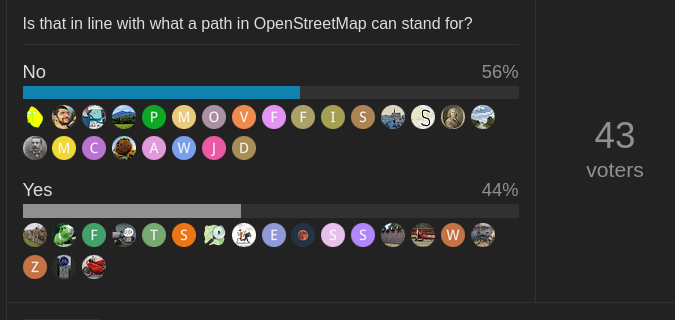
Is that in line with what a path in OpenStreetMap can stand for?
I’d say it’s enough to have it represented in OSM in some form. Whether highway=path is the right tool for the job is a different question. Probably not, something more specific would be better, but unfortunately we don’t have anything else at the moment.
Agree, that matches my expectations as well.
Trail visibility is completely independent of difficulty. You could have a trail over completely flat terrain that a child/senior could walk on without issues, but where there are no visible tracks because of the nature of the terrain (e.g. on a beach where tracks are washed away).
Sure. My point was that trail invisibiity should not be on its own enough to remove a trail from OSM (as some previous debators seem to suggest).
Administrative boundaries is also something that is largely invisible but integral part of OSM and one could think of a lot more examples probably (like a viewpoint, for example).
There are also other routes that are not visible but used and marked, like bus routes or ferry routes.
I assume a hiking route relationship would be an equivalent? But there is a slight difference here as anyone can use or mark a possible route on the ground but can’t really establish a new bus route (legally!).
Going a bit meta here - OSM wiki has “in_use” concept for things that are used but have not been approved. Roughly same criteria could be used for paths.
There is a small amount of usage of highway=scramble now.
This is even in the UK and IE, so I’ve added support here.
Small step to highway=orienteering
That’s why I think invisible and difficult hiking paths should be tagged with both trail_visibility and sac_scale to be acceptable for mapping them in OSM. See Alpinist routes marked as footpaths: A poll! - #7 by rhhs
You hum it, I’ll play it… ![]()
highway=orienteering
Mapping that would be considered cheating.
There should be a specific main tag (highway=‘climbing_route’ or something like that).
There’s climbing=route with more than 700 uses on ways.
Might be good to create a separate wiki page for this tag. Current documentation in sub section of key:climbing does not seem to be noticed by many.
OSM wiki has “in_use” concept for things that are used but have not been approved. Roughly same criteria could be used for paths.
informal=yes ?
in the while,

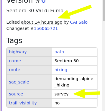
that guy edited it again. I noticed it has the: source:survey tag, while they admitted they didn’t surveyed the path themselves, and that the track is arbitrary.
that guy edited it again.
Have you tried to bring them into the conversation here?
An attempt was made here: Changeset: 155205011 | OpenStreetMap
the user replied and concluded with
No further communications will follow. Thank you. CAI Salò
I guess that a third party needs to get involved to propose them to come and discuss?
EDIT: I see that @SomeoneElse has done it already
I even have given the guy my phone number to talk about it - while I was also telling him that he can’t impose his will on everyone else and the path is not his, but he never replied.
Also, the path is not even of the CAI club! Despite what he states repeatedly, the CAI has an official list and map of CAI paths and that one isn’t one of those. It is just the idea of this guy and some fellows of him, as it is the (dangerous) idea to map it.
This is the official list and map of CAI routes/paths/trails. https://15.app.webmapp.it/#/map
So, how is this going to end (assuming that it is actually going to end somewhere)?

The (admittedly, not huge) majority here is against mapping that trail and the ones of that kind.
The mapper, though, doesn’t want to remove it, nor to listen or participate to the discussion apparently.
What does happen now?
What does happen now?
What are the options, and what are the implications of choosing one?
With an outcome like that it’s not plausible to say that the current way it is mapped is plain wrong. This poll amongst a small slice of the community shows that there is no clear consensus either way.
What’s next depends on what the problem that is being addressed is.
Better documentation of highway=path could help. Increasing awareness of sac:scale and mtb:scale seems useful (a wheelchair focussed map should probably consider both and take most values to imply wheelchair=no).
Anyone with some background in this topic could simply try to plan routes across that trail and see if the software used adequately warns/addresses/refuses that section based on the user’s settings and the application’s defaults. (For example: should OsmAnd or OrganicMaps use a section marked with higher sac:scale without asking the user? Is it a setting in their apps to use/not use those sections?)
Renders could be asked to make sure such alpine trails are rendered adequately.