I propose that we retag each of the township boundary relations in Maine, replacing admin_level=9 with admin_level=8.
Each of Maine’s counties is completely subdivided by townships and municipalities (plantations, towns, and cities). Townships are purely administrative subdivisions of the county’s territory and don’t have their own associated government. No township overlaps an organized local administrative area. Township names include or consist of a survey township name, but there isn’t a one-for-one correspondence between townships and survey townships.
There are 461 administrative boundary relations in Maine tagged with border_type=townshipadmin_level=9. The “United States admin level” wiki page had originally stated that townships in Maine should be level 7, but it was changed to 9 in February 2021 after twodiscussions among New England–based mappers on OSMUS Slack. From this more recent discussion, the reasoning was that the townships, being unincorporated, are less important than towns and cities.
I disagree with the current documentation and believe that the townships should be promoted to level 8. admin_level is for placing the boundary in a topological hierarchy of administrative areas, not for indicating the size or comprehensiveness of its government authority.
The key consideration is that a town or city cannot be located within a township; conversely, a township cannot be located within a town or city. Several other states have similar administrative structures at level 8 (or 7, in states where a township can contain a municipality). If you see references to named “unorganized territories” that contain townships, these appear to be Census Bureau designations, similar to the census county divisions in states like California that lack civil townships, so I don’t think it’s necessary to leave room for unorganized territories at level 8.
Across the U.S., many of the administrative areas at level 6 provide minimal government services compared to more local government units. The border_type=township tag is sufficient for informing savvy data consumers that there is something less significant about the townships. Mapping actual populated places as place nodes (with label roles) can reinforce this distinction. Promoting townships to level 8 would make the spatial relationship between townships and neighboring municipalities a little clearer, albeit with the downside that data consumers will have to rely on something else if they want to ignore unincorporated administrative boundaries.
As a side note, I think the “United States admin level” page has caused some confusion regarding the purpose of admin_level tagging. There’s enough discussion about forms of government that some mappers may have overlooked the key points about spatial containment and equivalence.
UT’s seem fundamentally different than towns. When you cross from one UT into another, you’re under the same administration (the state) so it’s debatable if it’s even an administrative boundary.
Regardless, I think it’s important that OSM tagging provides some level of distinction between towns and UTs. The admin_level tag was an easy (but maybe not appropriate?) way to do that.
If the admin_level tag is going to be made consistent between towns and UTs, who ever does that work should simultaneously add another clear and simple way to distinguish the two.
To clarify, the census-designated unorganized territories (UTs) haven’t been mapped, and I’m not proposing to map them. They seem to be groupings of convenience that automatically arise wherever townships happen to be contiguous. If anyone ever does map them, I think they would be a good case for boundary=census rather than boundary=administrative, in which case no admin_level=* tag would be necessary.
From my perspective, the townships (which are unorganized) sound like administrative boundaries: that is, the principal subdivisions for those parts of the county, more relevant to the notion of someone’s location than any other overlapping service area or district. I think this holds despite the lack of a dedicated government unit for each township. By analogy, the counties of Rhode Island are mapped as administrative boundaries, even though they only exist for some government bodies to organize the state, because you can still say that you’re “in” one without sounding like you confused “in” with “served by”.
Survey townships would certainly be something other than boundary=administrative, but those haven’t been mapped either.
I agree. I think the existing border_type=township tags are sufficient, assuming that any data consumer needing to make such a distinction would be able to interpret the border_type=* key contextually from region to region. (Some townships in Michigan are incorporated.) To me, an analogy would be that the U.S. has some unincorporated territories, but they still have the same admin_level=2 as states, not an admin_level=3 just because they’re less prominent.
Important to reiterate in this discussion is Minh’s comment that “admin_level is for placing the boundary in a topological hierarchy of administrative areas.” That is, how one place does something at its particular values of admin_level isn’t the same as how another does so, and the values are sensible and consistent within a larger context (higher part of the hierarchy / lower value of admin_level).
Another way to acknowledge this is to see clearly that a value for admin_level in one jurisdiction (let’s say “one of the fifty states” for simplicity and to “lock the context at admin_level=4”) — really below that admin_level value (as the jurisdiction geographically “contains” these) — can be (but isn’t necessarily) a different political entity. Examples are numerous: we have only two examples of admin_level=5 in the USA: the agglomeration of New York City (which is a collection of 6s: the county-equivalent boroughs like Queens and the Bronx in the context of a 4, the state of New York) as well as Tennessee’s “Divisions,” as the state is politically divided into Western Tennessee, Middle Tennessee and Eastern Tennessee, reflected in actual state law regarding judicial appointments and such and even on its state flag. These are wholly different political entities, so they get admin_level=5. But a 5 in New York is not a 5 in Tennessee.
Similarly, states, territories (Puerto Rico, Virgin Islands…) and commonwealths (Northern Mariana Islands…) and the District of Columbia are all admin_level=4 yet are fundamentally different sorts of governments. Although, at the same time, there are quite a number of states where the concept of “county” at admin_level=6 can be said to be pretty much the same as another state, though, this is actually coincidental and/or a mark of consistent naming yielding a kind of simplified “flattening” of the semantics.
It’s all about “within this context” (the nation, 2, as a whole, or any given state, 4, as a whole…). Maine is not Rhode Island is not Connecticut and so on. To determine that each state (or whatever, at any level) is a unique entity, with its own unique hierarchy determined by “lower levels” (higher values for admin_level) is 100% correct. So if Maine has a unique kind of hierarchy (and it appears it does), that’s perfectly OK, shouldn’t surprise or baffle us, and it is OSM’s job (with consultation of contributors from that state, for the best results) to properly (as best we can) denote that with admin_level (and perhaps border_type where it is correct to use that tag).
Perhaps Minh means here that unincorporated territories (for example, various islands collectively known as “Minor Outlying Islands”) have admin_level=2not the same as states (admin_level=4), and not as admin_level=3 just because they’re less prominent, but admin_level=2 because they are administered directly by a unit of the federal government (Department of Commerce, Department of Interior, Department of Defense via an agreement with the Department of Interior…). States are 4, a value of 3 does not exist (rather deliberately) and the federal government (directly) is 2. Whew!
(And yes: agreeing with Minh yet again, we don’t demote —to admin_level=3, for example — for reasons of “less prominent”).
It is easy even for highly intelligent people who have studied this in school and lived among the United States all our lives (I’m a member of that club) to get befuddled by these topics. I and OSM have spent many years tuning and fine-tuning these issues, as the hierarchies can be both bewildering and confusing (and even, in the case of Ohio, where Minh has stated in his Diary post something like “it is essentially impossible to craft such numerical hierarchies as admin_level=* with a sensible and consistent methodology”). It can be difficult (to understand and communicate) and craft (in OSM with admin_level=*, border_type=* and potentially other tags, like place=*) these among ourselves together with harmony and consensus. Yet, in places like this, we do. Let’s keep up good communication / dialog to do so, as it appears to be working, though somewhat-fragile the tagging we have done so far it may be. It isn’t so brittle it can’t be bent to accommodate the realities; we seem to be doing OK. But it can be broken with wholesale misunderstandings of how we’ve done things to get here.
I’ll say: “so far, so good.” And there is always room for discussion and improvement.
Oops, I did mean to write that the territories are admin_level=4 like the states and not 5 because of their legal status. I didn’t mean to say that they’re 2 like the states. Sorry for the confusion; it isn’t the first time I’ve flubbed this either.
One wrinkle I’m finding is that there are several cases of named unorganized territories in Maine which contain other townships. I think those should be admin_level=7, for example:
As noted above, unorganized territories are Census Bureau fictions, much like CDPs. If any have been mapped, they should be tagged boundary=census, not boundary=administrative.
I’m not seeing anything here that would indicate that these are census bureau creations (other than the area citation that every place gets in an WP article). It still looks, feels, and smells like a Maine thing and it’s hierarchical (within a county, contains townships). Whether or not they’re administrative? Hard to say since none of this is incorporated.
I’ve mapped them already here (we can figure out what they’re supposed to be tagged, the contiguous geometry was the hard part)
I expected changes to only cover township and I would discourage mapping anything of what you’re talking about in Maine as administrative boundaries. I have no reason to believe they are related to the census but I only know they are historical and only matter to modern times as the acronym on the township grid names.
I think there are multiple similar-sounding concepts that we need to distinguish:
Survey townships – systematically named, used in legal property descriptions, maybe mappable but definitely not administrative
Townships – unorganized by definition, distinctively named, often correspond to survey townships but not always, used as a point of reference for some government services, mappable as administrative boundaries with admin_level=8 but currently tagged admin_level=9
Unorganized territories (UTs, plural) – the Census Bureau’s automatic grouping of adjacent townships for statistical purposes, analogous to CCDs in some other states, only as mappable as CDPs, but definitely not administrative
Unorganized Territory (the UT, singular) – the state’s designation for all the townships and unincorporated islands collectively, conceivably mappable as a single administrative boundary with admin_level=7
Unorganized territories (UTs) are defined by the Census Bureau in nine MCD states where portions of counties or equivalent entities are not included in any legally established MCD or incorporated place. The Census Bureau recognizes such separate pieces of territory as one or more separate county subdivisions for census purposes. It assigns each unorganized territory a descriptive name, followed by the designation “UT” and a county subdivision FIPS and NS code. The following states have unorganized territories:
Arkansas
Maine
North Carolina
Indiana
Minnesota
North Dakota
Iowa
New York
South Dakota
In the context of Maine, a township is an MCD; the Census Bureau has designated UTs because there are unincorporated portions of counties that are not part of any township. I believe this conclusively shows that the unorganized territories you mapped should be tagged boundary=census.
Thanks, Minh. I continue eating my popcorn as I watch all this. It does seem the Census Bureau has something to teach OSM in this case. This might be one of those cases where these nine states with UTs are exactly as the Census Bureau describes them, and it behooves OSM to reflect this in our tagging as best we can. It does seem boundary=census is better on these, while omitting any admin_level=* tag whatsoever is correct. Yet, I’m also listening. (Crunch, munch…the sound of eating popcorn and listening).
I also love that an area ~10 times the size of San Francisco has 16 townships and 16 people!
I’m learning that those nine mentioned states have UTs, but doesn’t Alaska, as well? The famous, “bigger than any other state” Unorganized Borough, Alaska - Wikipedia (portions of Alaska which are not contained in any of its 19 other organized boroughs / county equivalents — effectively “state territory”), administered largely by the state of Alaska, and broken up into census districts (with mutual agreement between the state of Alaska and the Census Bureau)? Why isn’t Alaska a tenth “state with a UT”? (The biggest one).
Once again, this stuff ain’t easy. I honest believe a really smart political science professor well-versed in these topics specific to these 50 united states isn’t a bad idea to apply here. Even a good book somebody might recommend. I hesitate to reach for Wikipedia (even as I link it above) or other online sources, I want a slow, good, old-fashioned, by-the-campfire explanation by Aunt Suzy who really knows this stuff cold.
Just as the Maine state government recognizes a single Unorganized Territory while the Census Bureau recognizes several unorganized territories, so the Alaska state government recognizes a single Unorganized Borough while the Census Bureau recognizes 11 census areas. Maine’s Unorganized Territory or unorganized territories are subdivided into townships, while Alaska’s census areas are subdivided into census subareas.
I’ve just edited all named Maine townships to admin_level=8. They were all already border_type=township, so no change needed there. I applied this tagging to every admin_level=9 boundary that met the JOSM filter type:relation name~".*Township" -name~"T[0-9].*".
Before proceeding further, I think there are still some hanging chads that need to resolved.
I’m not sure what you meant by the distinction between the following two categories, and I’d ask you to clarify what you mean by them in the context of specific examples I’m going to lay out below.
I’ve encountered the following general categories of township (with the bold just being what I call them in my head):
Named townships - places like Blanchard Township, where there’s a clear name that’s distinct from the numbered survey system.
Leftover named townships - places like Andover North Surplus Township, which seems like “leftover” land after the town of Andover got carved off the regular Maine boundary grid.
Systematically named townships - places like Township C, where Maine just gave up on giving names and just started working its way down the alphabet.
Gridded townships - places like T1 R8 WELS – a place where I’ve actually visited and enjoyed a nice dinner with friends at a restaurant on a lake – but nonetheless lack a formal name beyond the Township/Rank grid system. Or its neighbor T3 Indian Purchase Township, named in a way that suggets a historic large-land purchase that has been similarly gridded up.
Systematic Grant Townships - places like Bowdoin College Grant East Township, which as named suggests a similar gridded carve-out from some historic land grant, alongside its similarly named westerly neighbor.
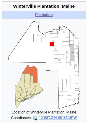
Plantations - such as Winterville Plantation, which seems to be a category of land that’s not reallllly incorporated but not realllly unincorporated but also not a township. There’s around 30 of these presently tagged admin_level=9 + border_type=township, though I think it might want to be border_type=plantation given its in-between status.
Gores - the true runts of the litter in unincorporated Maine places, and proof that the planners had both a sense of humor and an inflexible attention to detail, are slivers of land leftover from carving out the various grid systems and not added to adjacent gridded townships because reasons. Perhaps my favorite gore is the truly absurd Misery Gore, sometimes shown on state maps as “Misery Gore Township”.
These categories are all separate from the unorganized territories that Minh linked above, although there are cases of 1:1 mappings between a census bureau unorganized territory and an unorganized Maine township, presumably in cases where the township is not adjacent to other unorganized territory.
Wikipedia draws its county maps of Maine in the following way, wiping the map of much of the unorganized areas:
So right now we are out of sync with the wikipedia treatment, which doesn’t make our current mapping wrong per se but I think we need to examine our approach and decide what we think is mappable.
I have taken the stance thus far that all of my bolded categories, which together with cities and towns are collectively space-filling for all of Maine’s territories, are mappable as administrative boundaries (initially as level 8 and 9 depending on incorporation, but now by apparent consensus all level 8). This was the conclusion I drew with @blackboxlogic when we intially completed the map of Maine boundaries back in 2021. So if we are not in agreement on that point, then I think we need to figure out what counts and what doesn’t, and how we actually decide how to draw the line, and what to tag the orphan land that gets left behind if any.