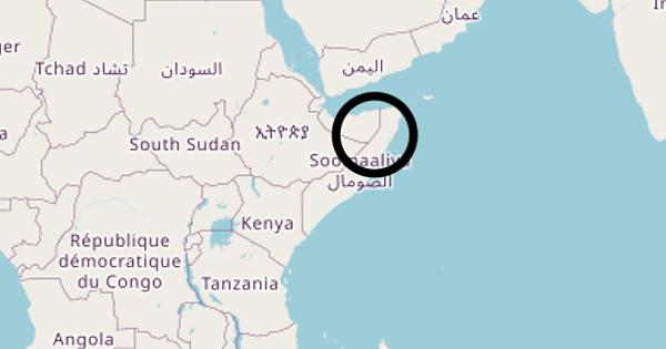
What was the reasoning behind this distinction between Somalia and the province of Somaliland. I understand alot of organization utilize OSM maps and its getting annoying seeing my country’s borders redrawn. What is the process to change this? When maps like this make a distinction like this it flames the fire of tribalism and division.
Disputed territories - OpenStreetMap Wiki may have helpful info.
Also, Relation: Soomaaliland أرض الصومال (3586169) | OpenStreetMap seems to be not mapped as separate country but as subdivision of Somalia.
Well, looking at the members of Relation: Extent of Somaliland Claim (13563059) | OpenStreetMap I find different names and I wonder if admin_level=2 is correct. I would have expected admin_level=3.
Maybe, @SomeoneElse can tell us more as he was already involved in reverts in this area.
I don’t believe that there actually is one. Here is Somalia. It is an admin_level=2 country. Here is Somaliland. It is an admin_level=3 disputed territory, not a country.
If you see a map that fails to display this properly, please contact the creators of that map.
That does make some sort of sense - to be clear the tagging is “boundary=disputed” - it’s claimed to be admin_level=2, but is disputed. Note that it’s not an administrative boundary
Thanks, but I am talking about the members, e.g. Way: Somalia - Republic of Somaliland (1007453958) | OpenStreetMap or Way: الصومال - صوماليلاند (126925018) | OpenStreetMap which are tagged boundary=administrative, admin_level=2 and have different names.
It doesn’t make sense for https://www.openstreetmap.org/way/1007453958 to be “boundary=administrative; admin_level=2”. I’m pretty sure that most or all things handling “what is a country” are going to be interested in polygons, not lines, but it’s not impossible that some rendering will use the admin_level on a particular way for “how to draw that line”. The error dates from a while ago - you’ll see that my reverts since then have (in error) reapplied admin_level=2 where other users have changed it as part of some other problem changes that broke relations.
Note that OSM Carto displays this boundary as “3”, not “2”.
Edit: Not at zoom levels 1-3 (see below for more detail).
It may be a good idea to simply remove tags from ways here (there are some cases of data consumers using this tags ways, but duplicating relation tags on ways is something that we would ideally eliminate[1] - especially here where data is contradictory).
[1] You can look at Poland to test whether it would break anything, community there decided to get rid of boundary=administrative way tagging
Removing all tags needs a broader discussion, I guess, and I am by far an expert for boundaries.
I have just changed the value for admin_level from 2 to 3 and leave the rest to experts and local mappers.
Okay maybe there is not an official distinction but for example, take in this clear border that appears when you zoom out a little bit. Most video content , newspapers, data aggregators use this map and that little straight border make it appear that the Somaliland region is its own independent nation.
Heres the border I am referring to:
I’m afraid you’ll have to take that one up with the OSM Carto designers. It would be a really difficult problem to fix, since different admin_levels are used for different things around the world, and different people want to see different things
Is it possible that it appears only when Natural Earth data is used on lowest zoom levels?
(not sure is NE still used for lowest zoom levels)
The way that OSM Carto handles boundaries is spectacularly opaque and prone to failure. I had to anticipate certain failure modes when writing the switch2osm guides such as this one. Basically, this script uses this file to decide what to download, and that does include data from https://naturalearth.s3.amazonaws.com/110m_cultural/ne_110m_admin_0_boundary_lines_land.zip. That is then used here as “necountries” (zoom 1-3) and then defined here.
Looking at https://github.com/nvkelso/natural-earth-vector/tree/b70b7b8766c3c83d5f5145cb6f1c93921d383d3f/geojson the issue might be that the NE data doesn’t actually represent what OSM Carto thinks it does here.
It’s still an OSM Carto bug, of course. Even if OSM Carto used OSM data here, I’m not convinced that the difference between admin_level_2 and admin_level=3 would be great enough at zoom 3 (if both are shown) to not still show the problem.
Edit: I’ve added this at https://github.com/gravitystorm/openstreetmap-carto/issues/4803, but as I mentioned above this is a hard problem to solve, so I wouldn’t anticipate any quick fix here.
Also, it may make sense to report to NE problem of classifying Somaliland - if present in latest NE and not reported already (they may have own criteria where it may or not make sense to classify it in this way).
