I am a beginner user. I am attempting to label a map of a trailer park for our school transportation department. I want to label the lanes inside the park as well as label each trailer home with the trailer address number. I want only the standard view map of the trailer park. When I pull up what openstreetmap has for this trailer park, none of the trailer homes are showing. It’s open space with only the street lanes showing. The surrounding homes show on the map as dwelling icons and house numbers but nothing in the trailer park. The trailer homes do appear on google maps. Is there any view where the trailer homes would be shown or a way to import them from google maps so that I can label? I do not want to have to manually add all 109 trailers. Any help would be appreciated!
Possibly they have not been added to OpenStreetMap.
If you tell us where this is, we might be able to tell you more.
That is generally how OpenStreetMap works. If something isn’t on the map, you need to add it - or get others to help you add it.
The name and location of the trailer park is:
Grandview Mobile Home Park
501 E. 10th St.
Eudora, KS 66025
The name and location of the trailer park is:
Grandview Mobile Home Park
501 E. 10th St.
Eudora, KS 66025
Thank you for looking at this!
This is what is in OpenStreetMap for this area right now:
Link: https://www.openstreetmap.org/#map=17/38.940047/-95.090983
I see some houses mapped, mostly on west side of Church Street. Houses immediately adjacent to the mobile home park (for example Ash Street) do not appear to be mapped. The mobile home park itself is also not mapped, except for the roadways as you mentioned.
If you are seeing something else (like houses with details on Ash Street or Birch Street), you are not looking at OpenStreetMap, or at least not exclusively OpenStreetMap data.
If you are using OpenStreetMap, there is no easy way out - the houses have not been added, someone will have to go and add them. It could be you!
Hi Kyleef, welcome to OSM and our forum here!
Agreed, and besides that import of data from Google is not allowed due to license restrictions. Moreover import of building data generally is of poor quality in many cases and needs manual refinement afterwards. The best way to get these trailer homes into the database (and the map) is by entering them manually.
Besides the trailer homes I’d say 90% of the buildings of this township are not yet mapped (see earlier post of @Jarek), so this is a great place to start mapping!
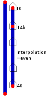
If you don’t want to map every individual trailer home but each street lane has addresses in a certain range, you may want to interpolate addresses.
Interpolation
If we don’t know (or don’t have time to find) every house number, we can use interpolation. This allows people and machines to guess where an address probably is, between two known points.
You need to know two house numbers, and the sequence pattern.
E.g., in a terrace of houses, perhaps you know that the first house is 15 The Road, the last is 27 The Road, and that this side of the road the house numbers are all odd.
Basic instructions
- Create a node for the lowest-numbered address
- Tag it with
addr:streetandaddr:housenumber.- Do the same for the highest-numbered address
- Draw a way from the lowest-numbered address node to the highest-numbered address node
- Tag this with the correct interpolation tag (see Tag options, next section).
Tag options
The basic tag for the interpolation way is
addr:interpolation=*Common values for
addr:interpolation=*
Value Meaning all House numbers between the nodes are in strict numerical order. odd House numbers are in numerical order, odd numbers only. even House numbers are in numerical order, even numbers only.
I have added the trailers, you will have to attach address details to them. I recommend StreetComplete on Android.
Thanks so much! I appreciate your help, it was very kind of you to help me on this.
For future mapping, you can also use Rapid editor which gives you ai generated buildings to validate and correct. You will need to correct a lot of them and in some cases scrap and draw yourself, but i’ve found it faster than drawing all by hand.
As people have mentioned the OSM project need local people mapping their area.
If you want you can l arm how to put your neighborhood on the map. It can be quite satisfying and addicting.
I like learnosm.org as a starting resource because it gives you and overview of what the project is about and how you can get started contributing
People have mentioned some good tools as well already.
one very easy way to contribute is StreetComplete which simply gives you some questions you can answer while walking around.
It is not yet available for iOS though Hu will be soonish.
Another sweet App is EveryDoor https://every-door.app/ ch is available for Android and iOS
At the end when you start diving a bit deep into OSM, you’ll find the Wiki to be one of the most valuable resources.
I see you have started adding addresses ![]() Welcome to the editor club !
Welcome to the editor club !

