I’ve seen an issue with a street name - Bob-O-Link Drive in the Lakewood neighborhood in Dallas. Having surveyed it on the ground, there are 6 street signs with the spelling “Bob O Link” and 3 with the spelling “Bob-O-Link”. The only other reference I’ve seen to the hyphenated spelling was in bus stops in the DART network (cross-referenced with the DART website.) All other sources I could find, including the USPS address database, use the form with spaces. It may seem like an obvious choice to go with “Bob O Link” since the majority of sources use this form, but this conflicts with the OpenStreetMap wiki.
According to the “on the ground” principle and “Naming Disputes” section of the wiki, the way the residents spell it should be the name on the map (though it’s also supposed to be a consensus with the street signs.) Is the proper way to resolve this to ask people who live there? Because it would be awkward trying to explain why I want to know how to spell their street name… plus, I’d assume most residents would use the same spelling as official databases to avoid issues with computers failing to understand their address.
Either way, it seems like there may be issues with data consumers being able to find the name. I already modified the street and houses to remove a certainly incorrect spelling of “Bobolink Drive” and in the process, added alt_names to help mitigate this issue. A similar but much clearer example is Wycliff Avenue in Oak Lawn - at this intersection, the street sign is spelled “Wycliffe”, but all other street signs use the existing spelling. I know people who live along this road and they always spell it without the E - so a clear consensus that the existing spelling on the map is correct. My point in saying this is, there may need to be some clarification in the wiki about what to do with conflicting street signs and whether mappers are obligated to ask residents before changing a name.
I’d do pretty much what you’ve done with the following exceptions: First, you put the “certainly incorrect spelling of Bobolink Drive” as one of the alternatives. I would not have done that. Second, you’ve obviously done a survey of the location but you did not remove the tiger:reviewed=no from the street.
And I have to agree with you that the wiki should be a bit more clear on what to do with this type of conflict.
Proper way would be to reach out to local authorities and asking, whether the different spelling is intended.
After your research it’s seems to me obvious that “Bob O Link” is the name of that road. If there is someone disputing your research, you might end up with “Ground Truth”. I would add the other spelling in alt_name.
One thing I like to keep in mind is that various “sources” may have deliberately chosen to use a reduced character set. This is most common for older/smaller street signage as well as the USPS database. This makes things simpler for them but we don’t have any such restriction. In this case, I would say the name for OSM purposes is “Bob-O-Link” with, perhaps, alt_name of “Bob O Link”.
Agreed, these databases all have different rules for their own purposes. The USPS prefers spaces but allows hyphens. The MUTCD prohibits signposting the “Lp” abbreviation that TIGER insists on. If it’s still a tossup even after considering the underlying reasons for a discrepancy, such as a blatant mistake, then pick one spelling to go in name=* and the other to go in alt_name=*.
In general, I prefer to put the less austere spelling in name=*, since it communicates information that a user or data consumer might miss otherwise. For example, TIGER lists this street’s name as “E BUSINESS WAY”, with “E” as the directional prefix. Many maps and navigation systems therefore expand it to “East Business Way”, but in fact the street’s name is supposed to be “E-Business Way”, as in electronic commerce. Similar confusion can arise due to a missing period after the middle initial of a personal name. (Let’s go to Chuck East Cheese’s today!)
The stakes are considerably lower for alt_name=*, which can hold multiple values separated by semicolons. I wouldn’t flinch at seeing alt_name=Bob O Link Drive;Bobolink Drive, though if one feels strongly enough about it, there’s always not:name=Bobolink Drive.
Wherever the signs on the ground are inconsistent, I also map the signs themselves as street name sign nodes. This explains my tagging choice to mappers who come along later, discouraging them from naïvely undoing my work based on one source or another. In the past, I’ve even been able to stop slow-motion edit wars by mapping these signs.
I’ve mapped one of the stop sign assemblies at the intersection with Sperry Street so you can see what this might look like in your case. There’s still ongoing debate about some aspects of traffic sign tagging, but the point of this exercise is simply to show your work, so it doesn’t have to be perfect.
I also encourage folks to send emails off to their DOT or GIS departments. Doesn’t have to be super formal “I noticed this was inconsistently signed” and you may not get a response but sometimes you do and it’s always a treat.
Though for very important articles like about name tag it may be better to create a separate dedicated thread about proposed change.
(If street signs are present and it is not some country under occupation of hostile power that is trying to change used names - I would say that there is no obligation to ask residents, but it is likely to be useful. For example they may point to more signs being present)
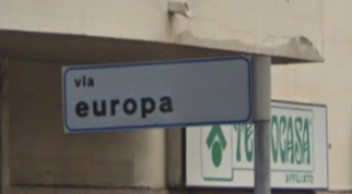
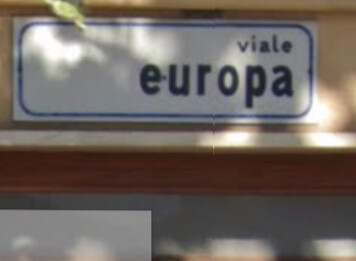
Here’s a classic for you…
West side entry of what ‘was’ known as Viale Europa
Spoke to the pizza shop keeper, she said yes we changed our address too.
2/3rd into the street, over a house entrance at a T-junction, Viale
Then at the east end, Viale.
Thanks for all the advice, everyone! Lots of useful info here to help figure it out.
I hadn’t read any documentation on TIGER tags before, so I’ve always left them alone; I’ll do that from now on!
Good point; I wanted to make sure that name was included in some capacity since it’s been on OSM for some number of years now. I’ll use the not:name as you mentioned since the wiki page for alt_name says multiple values generally should be avoided.
Great idea, I didn’t know this was possible! I’ll map the signs too.
Keeping all this in mind, I surveyed the street again today, paying much more attention to signage, and saw that several houses had permanent address signs out front with the name spelled “Bob O Link”. There was also a building permit out front of a house under construction using the same spelling.
With the second survey, the “Bob-O-Link” street signs appear to be older than the others, so it may have been changed over time. It’s entirely possible that this was because of such databases showing it differently, but because several people who live there put signs in their yard that are all spelled “Bob O Link”, and considering the majority of street signs and official sources concur, I think I’ll go with that as the stronger “ground truth.”
Sounds like a good idea, but considering it’s only a difference in punctuation/whitespace characters and not the actual pronounceable name, I think I’ll leave it at that for now. Should anyone else wish to do so, I welcome others checking my work. In that spirit, I’ll add a note to each of the ways linking to this discussion in case anyone wants to see the rationale behind the name.
Oh, maybe that’s a little too strongly worded. I think the intention was just to get mappers to consider more specific keys, such as old_name, before dumping yet another value into alt_name. Pretty much the only kind of data consumer that can use alt_name is a geocoder, because its values are too undifferentiated to be displayed to the user.
Pretty much the only kind of data consumer that can use alt_name is a geocoder, because its values are too undifferentiated to be displayed to the user.
I actually process alt_name and may display it on my topographic map rendering depending on how different it is from the name value.
Oh, fascinating! That’s unique enough that I think you should mention it in the documentation, so people at least put some thought into what goes in that key.
At this point, take a marker pen and fix the sign
We must not tag for the renderer but nothing in OSM rules says we can’t tag the ground for OSM.
It’s not vandalism if it not in the database!
Later this week in a local newspaper: «Person arrested for changing over a hundred street signs. Supects makes incoherent claims about not being an automated edit, having reviewed each changes manually and accusations of moderation tyranny, confusing the investigators.»
You are half-joking but in some cases getting local government to fix confusing signage is easier than figuring out how to tag it in OSM! (and also fixes actually existing problem)
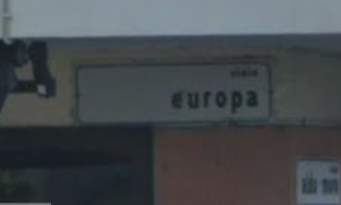
And so we (moi) found in real real closeup with the sun full on the sign that it prints ‘vla Europa’ abbreviation for viale, not ‘via Europa’, not being the only one seeing it wrong and the makers seemingly short of ink. Resolved \o/