What’s new on the OpenStreetMap website?

More color, prettier links, and less swimming

By popular demand, I’m starting a regular series of posts summarizing the changes taking place in openstreetmap-website – the main OSM website and API. I trawled the many merged pull requests and commits from March 16 to today, distilling them into a hopefully more digestible list. Since the community here is mostly mappers and other casual website users rather than coders, I’ve mostly focused on user-facing changes.

In the future, I’ll continue posting the updates to this thread roughly monthly. Please subscribe to this thread if you want to keep getting updates, or mute it if you already follow the osm-website project closely enough that I’d be insulting your intelligence.

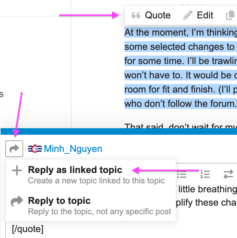
Before I begin, I have a small request: if you have any feedback about an individual change described here, please start a new thread about it. To do this, select the bullet point you want to respond to, click ❝ Quote or press Q, click the :arrow_right_hook: button next to my name, and click :heavy_plus_sign: Reply as linked topic. That way, I’ll be able to reuse this thread without spamming the forum category. Thanks for your consideration.

Without further ado…

Slippy map

Directions

History

  • We refreshed the map overlays on the main History page. The map can start to get crowded with bounding boxes after you load several pages’ worth of additional changesets. Now the bboxes are color-coded by age based on the sidebar’s scroll position. The scroll position also determines which bboxes you can select on the map, so that the newer changesets you saw initially won’t get in the way of selecting older changesets you’ve since loaded.
  • If you position the map to straddle the antimeridian, all the relevant bboxes now appear, on both sides of the antimeridian. Even if you aren’t particularly interested in monitoring Taveuni, this bug fix makes the map useful when you zoom out to see the whole world multiple times over.
  • While you play around with the new overlays, you might notice that the before= or after= URL parameter is synchronized with the scroll position. You can use these parameters to jump directly to a long-ago slice of history instead of spending a whole afternoon loading 20 changesets at a time. (I’ve done this. Do not recommend.)
  • We corrected the license of the history Atom feed: ODbL, not CC BY-SA.

User accounts

Editors

  • We upgraded iD to version 2.33.0, then v2.34.0. Both versions come with a number of improvements.
  • When editing in iD, the page title says “iD” followed by the name of the feature currently selected in iD. This makes your iD window or tab easier to distinguish from the homepage.

Diaries

Other user-facing changes

For data consumers

For developers

You can help!

Thanks to recurring contributors @amire80, andy_allan, anton_khorev, @user10, danieldegroot2, @David_Tsiklauri, @hlfan, @holgerjeromin, @karussell, kcne, rkoeze, TomH, @trickyfoxy, and @tyr_asd for these and other changes that are less visible but no less important. And a special welcome to first-time contributors @harel_m, @neatnit, and Valchee!

If you’re familiar with some of the technologies the site uses, like Rails or JavaScript, we have a large backlog of outstanding pull requests that you can help review informally, helping the maintainers assess which ones are most ready to land. Occasionally we tag an issue as a good first issue, which means it’s well-defined and doesn’t require much background knowledge. If you don’t have a coding background but speak a language other than English, help us translate the website and other OSM software into your language.

This list of changes is pretty long, and maybe you were surprised to see some of it landing now. Over the coming months, I’ll be working with maintainers to articulate a roadmap for this and other core software projects, so you’ll have a general idea of the larger things we want to prioritize. Your feedback as community members will be crucial to putting together a useful roadmap.

How are we doing?

If you have any feedback that isn’t quite formulated well enough for an actionable GitHub issue, feel free to reach out to me directly via a private message on this forum or osm.org, or e-mail me at minh@[the OSMF domain]. (I also lurk on a few chat platforms.) My formal role as CSDF will focus on often underappreciated infrastructure, but even if you’re interested in something more user-facing, I can at least try to connect you to the right people in the community.

I’d also appreciate feedback about this post in the meta discussion about keeping track of changes. Are these bullet points putting you to sleep? Do I need to explain the changes in more detail? Would you also like to hear about non-user-facing changes such as refactoring and unit test coverage?

85 Likes

Tidier directions, your social media presence, and languages you’ve heard of

The last recap covered a lot of ground. This time I’m only going to cover a single month, from mid-May to mid-June. It’ll be a little less eventful, but only a little less.

Slippy map

Map data

  • Address point labels are more consistent between the element inspector and feature querying results.
  • If you get rate-limited for downloading too much data via the Map Data overlay, the error message explains why and tells you how many seconds we’re giving you to make a pot of coffee or tea or ramen.
  • When you use the Query Features function, the “Enclosing features” section lists boundaries by area. Now Russia and other big areas spanning the antimeridian show up in the correct place in the list, befitting their large size.

Directions

History

  • On the History tab, if you lose your place in a long list of changesets, you can right-click a changeset bounding box and select “Scroll to changeset” from the context menu.
  • If you use the website in a left-to-right writing system, changeset comments in a right-to-left writing system appear in the current order without jumbling the words.

User profiles

Settings and preferences

  • Whether you speak da or ja or uk, you probably don’t find ISO 639 language codes to be very intuitive. They look like country codes but aren’t. Now you can choose your preferred language from a dropdown menu with human-readable names. So if you’re fluent in tlh but conversant in eo and can barely hail a cab in la, you can still set that fallback list in a new Advanced Preferences tab.
  • We removed the button to log in using OpenID. This only used the legacy version of the OpenID protocol. Hardly any sites support this version anymore, and for those that still do, the option wasn’t working.

Editors

User diaries

  • We added a New Diary Entry button to the top of each of your diary entries for consistency with the main index page of your diary.
  • We added a section to each user’s profile page previewing their most recent diary entries.
  • We limited how much text you can put in a your user profile, diary entry, or diary comment. There have been some really long ones, but we tried to avoid impacting anything legitimate. (This forum has similar limits, in case you’re wondering.)

For data consumers

Yay!

There’s even a little more than this that hasn’t been deployed, so it’ll have to wait for next month’s recap. Thanks to @anton_khorev, @hlfan, kcne, mahmoudhanafy, @mmd, nertc, rkoeze, @TomH, and @tyr_asd for your continued contributions to the project. See the first post above for some ways you can help out. If you’re attending State of the Map U.S. in Boston later this week, please do me a favor: corner me and talk my ears off about your experiences, hopes, and dreams for the core OSM software. Let’s get it all off your chest.

37 Likes

2 posts were split to a new topic: Compliance issues with numerous new website features

5 posts were split to a new topic: Suggestion to improve edit buttons on OSM.org user profile

Q130350264, Q7214489, Q107659597

With the launch of vector tiles on the homepage and other long-awaited features, it’s a good time to be a daydreamer. Change is possible!

Slippy map

  • The Map Layers sidebar offers two new featured layers based on vector tile technology. Shortbread and MapTiler OMT make it easier for you to see the impact of your mapping on maps that are based on the Shortbread and OpenMapTiles tile schemas, respectively. If you have any questions or concerns about these layers or ideas for improving them, please see this guide to the various software components involved that you can submit feedback on.
  • Click the new 文A button at the top of the homepage to change your preferred language, even if you’re logged out. Besides the user interface language, this setting also affects the language of map labels in the MapTiler OMT layer, so you can much more easily detect missing or incorrect place names in regions where your language is a minority language.

Map data and history

  • The history page for an element with many versions paginates to reduce loading time. Click the Older Versions and Newer Versions buttons to see more versions.
  • When viewing the details of an element version, a new scrollable navigation bar lets you navigate among versions more easily without accidentally landing on a page you didn’t expect. If there are a lot of versions, it skips some so you can more easily jump around.
  • We reorganized the per-changeset statistics on the history page so they’re easier to scan, and these icons also appear on other pages that link to changesets.
  • Per-changeset statistics distinguish between elements added, deleted, and modified using a :horizontal_traffic_light: indicator, like in OSMCha. (This only appears on a small number of changesets for now but will become more prevalent later.)
  • Click the Wikidata logo next to any wikidata=* or *:wikidata=* tag value to reveal a more user-friendly label, description, and image. This feature is based on the Human-Readable Wikidata browser extension.

Search and directions

  • Search terms stay visible in the search bar on the homepage as you open and close sidebar panels until you close the sidebar.
  • We fixed the appearance of the “Where is this?” button in the search bar in Firefox.
  • The distance unit toggle button can accommodate the longer words in some languages and also distinguishes between American-style miles and feet and British-style miles and yards.
  • The map markers indicating the origin and destination of a route include :arrow_forward: and :stop_button: icons so that you don’t have to distinguish them by color.

Settings and preferences

User profiles

Other changes

  • We added a banner for State of the Map 2025 in Manila. See you there!
  • Every paginated list, such as GPS traces or diary entries, now includes older and newer and oldest and newest buttons at the top and bottom of the page.
  • Fixed an issue where an image at the end of a diary entry could break the page layout.
  • Upgraded iD to v2.35.1, v2.35.2, and v2.35.3.
  • An error appears as an error if you attempt to send a report to the administrators that lacks the required fields.
  • We fixed an issue where the OAuth authorization flow would lose the referrer and wouldn’t reach the right welcome page.
  • Fixed JavaScript functionality such as the search results in very old browsers such as Pale Moon and Firefox 85. Note that these old browsers are no longer officially supported.

For developers

  • :warning: We changed how some third-party tools can authenticate with the website through OAuth. This broke some third-party libraries and tools. Please see our security announcement for guidance on fixing regressions.
  • You can customize attribution strings in API responses using new environment variables at compile time.

For contributors

  • We added a command for easily registering the required OAuth applications.
  • You can contribute SVG images as individual files that get inlined automatically.

Thanks to @Koreller @_martin @Pikse for contributing their first pull requests to the website, to @ZeLonewolf for making his browser extension code available to crib from, and to the MapTiler team for their patience and persistence in getting MapLibre integrated into the site. Meanwhile, @pnorman gets all the blame for dragging us into the modern vector era. :stuck_out_tongue: Thanks also to our regular contributors, and to all those who took the time to review the pull requests and provide user feedback on them before the changes went live.

37 Likes

Faster element lists, more links, prettier alerts

Data browser

Slippy map

Notes

Authentication

User profiles

Editors

Localization

  • The language picker captions every language in English in case you can’t recognize the language’s own name for itself or don’t have adequate fonts for the language. (An upcoming change, not yet deployed, will localize these captions.)
  • We added a new localization in Arpitan.
  • Raw MediaWiki wikitext syntax no longer appears on the notes page or in e-mail notification subject lines in some languages.
  • We fixed another issue preventing accurate translations of the term “Terms of Use” into some languages.

Other user-facing changes

For data consumers

For developers

Changes that may be relevant to developers who maintain their own instance or fork of openstreetmap-website, but not to the main OSM website instance:

For contributors

The more the merrier

A warm welcome to @jleedev, @larouxn, MAHanupriSAR, @OrichalcumCosmonaut, @pablobm, praszuk, and siyulai21, who made their first code contributions this time around. They join recurring contributors hlfan, kcne, @mapmeld, @Pikse, @placemarkt, tyr_asd, and @user10.

We also need help reviewing pull requests by others, so it’s great to see HolgerJeromin, mapmeld, nenad-vujicic, petr-hajek, and pnorman stepping up.

And we can always use some help translating the software into various languages so mappers can contribute more easily. Thanks to Aegis1009, Albertoleoncio, Arely, Eihel, Elzav, @jemily1, @KX675, L’Arpetani, Modin, MoritzMT20, Sampi│ϡ, संजीव कुमार, Tauqeerkhansurani, and Xhulianoo for joining the translation effort.

Finally, you may have recently seen the Core Software Development Facilitator come up in election discussions. I appreciate the recognition, but to be perfectly honest, I don’t deserve so much credit yet for how much has been moving in the core software projects. That’s really been anton_khorev, mmd, and TomH actively tending to the projects as volunteer maintainers. The other support work I do behind the scenes would not be possible without their cooperation.

30 Likes

Tweaks to languages and developer experience

Hello OSM community! My name is Pablo and I am the new Core Software Engineer employed by the OSMF to work full time on the OSM Website. This month it is my pleasure to let you know what’s new.

Let me start by asking: will you be attending State of the Map Europe 2025? It will take place in the city of “jute, jam and journalism”, otherwise known as Dundee, Scotland. If you didn’t hear yet, the banner is now up on the website. I’ll be there, so please come to say hi if you see me!

This month has seen less user-facing activity, and more focus on the development experience. Hopefully that’ll bring us more visible changes in the future! Here’s the summary.

Localization

Usability

Software Development

This is a community effort

We wouldn’t be able to do this without everyone who makes the OSM community:

Thank you all so much!

46 Likes

More dark mode, less missing data

Here we are yet again! These are the changes we made to the website since the last update.

User interface

Data and API

Developer Experience

Code refactors and cleanups

We have the best contributors

23 Likes

(Continued from above, which I had to split to work around a limit in the forum software).

12 Likes

This one confused me …

Where are we using Overpass for data export?

Ok found it … Overpass adds a couple of extensions to the output format, I’m not quite clear on if they could potentially cause issues with unsuspecting users or if in the mean time everything supports / ignores them.

1 Like

As it says in the pull request description, if you go to the Export page and click the “Overpass API” link (as opposed to the Export button), it actually kicks off an Overpass API request. This caught me by surprise too.

Eye-catching emoji, links that actually link, gifts for working groups

Our core software projects managed to slip in a few more treats before the end of the year:

Slippy maps

Data browser

Directions

Moderation

Internationalization

Other changes

Behind the scenes

As always, we’re also carrying out many refactors and upgrades to modernize and streamline the codebase. We’re also improving the reliability of automated tests and other development tools. The results aren’t as obvious to all of you, but it makes everything else possible and paves the way for future improvements.

The team is growing! @hlfan is our newest maintainer, after contributing quite a bit over the past year. @HolgerJeromin and I will also be helping out with triaging.

Welcome to our first-time contributors: @CommanderStorm, @gergelypap, and @aNsHuL5217 (who chose our website to make their very first open source contributions)! If any of you have been waiting for the right moment to get off the sidelines and help out, maybe now’s the time. We’ve updated the guidelines for contributors to mention the new core software roadmap and expectations for organizing commits and branches, which will hopefully reduce some potential friction.

Welcome also to our new translators: Anon (German), Asteralee (French and Italian), ExoHyper2026 (Simplified Chinese), Kunokuno (Central Bikol), MeahNunh (Khmer), MonX94 (Ukrainian), Penyuwangi (Indonesian), ShiminUfesoj (Central Bikol), TheRabbit22 (German), Wawrzec (Polish), and Yeager (Swedish). If you :speaking_head_in_silhouette::heavy_plus_sign::heavy_plus_sign:, check out all the different projects that are waiting for your translation help, including our website.

And thanks to @awiseman, @CommanderStorm, @HolgerJeromin, @pablobm, and @pnorman for helping our maintainers review pull requests. You help us maintain quality in a growing project.

41 Likes

Thanks for the update and the hard work everybody put into our little project here :slight_smile:

My favourite that I already noticed is that $key=$value in CS comments gets turned into links. That is a great upgrade for those pesky commenters like me

Happy Holidays, if applicable

9 Likes

9 posts were split to a new topic: Indoor mapping request

More MapLibre progress, more context, fewer bugs

Happy new year to all in the community! Activity in the website has barely paused despite the holidays. To prove it, here’s a list of the latest changes you may have seen this month.

Slippy maps

Providing more context

Internationalization

Small features and fixes here and there

For developers

22 Likes

(Separate post due to Discourse’s limitation on the number of users I can @-mention in one go…)

Additional thanks to @Minh_Nguyen, @HolgerJeromin, @mmd, @Anton_Khorev, @danieldegroot2, and @waldyrious, all of whom helped reviewing the changes.

A very warm welcome to @SykoDaedalus and @snehaljadhav7317, who made their first code contributions to the project, as well as to our new translators: Aindriu80 (Irish), Escargot bleu (French), Grandasse (French), @hangukhistory (Korean), LeoGe25 (German), OwIultra (Persian), Rusjanis (Latvian), Tecbs (Spanish), Username1233219128 (Slovak), and @ZigaD (Slovene).

15 Likes