First of all, I am mapping for acessibility, in the context of sidewalks being mapped as geometries.
So, kerb cuts can be individually mapped.
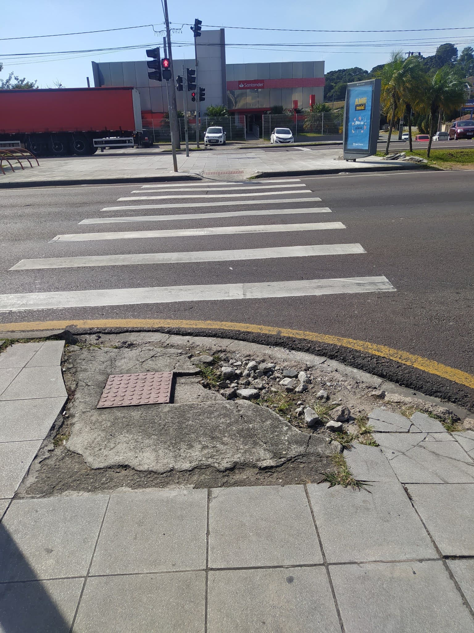
But i’m really in doubt about broken ramps (in many different levels of “brokenness”).
They (like the one in highlighted in the attached surely can be tagged as:
barrier=kerb kerb=lowered
and also surely, can’t be tagged as wheelchair=yes…
we may use smoothness? just add a “description=broken ramp” ? (will face standardization problems, surely)
I really think that a “state_of_convervation” key with values ranging from “100%” (brand new) to 0% (totally destroyed, impassable) shall be a great idea.
There was recently some discussion about the possibility of using a “broken” life cycle tag in the threads about sidewalk ways and pedestrian signals. tactile_paving=incorrect is a growing tagging scheme, but that is intended for tactile paving which was installed incorrectly or which doesn’t serve the function it is supposed to.
It may be worth assembling some kind of proposal for tagging broken features if there are multiple mappers encountering this. I agree it’s worth reporting, but as I have brought up before, in some regions the likelihood of a report resulting in
I would rather a scheme for broken be binary though - it’s either broken or it isn’t. A scale is too subjective, and ultimately the answer of whether or not a feature is capable of fulfilling its intended purpose is just yes or no. To that end, this kerb + tactile paving is just broken.
There was a study in my city of the percentage of sidewalk which met the ADA safety standards for people with disabilities, which are based on quantifiable metrics for their condition. It found that over 98% of sidewalks in the city don’t meet legal standards - even if I tried to use a reference point to rate things on a scale, it would mean tagging nearly everything I see as some degree of broken between 100% and 0%, which is not really usable information.
Very interesting, can you share the report from this study? I am also a researcher on acessibility mapping, and i’m very interested.
But I want to disagree with the binary option. I would say that a numerical grade for brokeness can be imprecise (linked with “standart deviation”) rather than innacurate (far from the actual value), no one may put 100% on a really broken feature, but may put any value ranging from say 10% to 30%, maybe 40%. So one may discretize afterwards, even in a binary way.
I have a lot to learn in the field of acessibility and anti-capacitism, but there are a huge variety of disabilities, people in wheelchair can have many levels of mobility restrictions, so say just “no” may put off many people that actually could pass trough that kerb. Yes, that broken kerb needs to be repaired, but unfortunately the real world is far worse, so we may need to do the best we can with what we have, of course, never forgetting the fight for better days.
this looks as if a wheelchair user can still use the feature. I am not mapping this kind of damage at all because there is far too much. If your local government has the will and resources to fix it, ok, if it is “normal” that the surface is damaged in many places, then map those that are really an unsurmountable obstacle.
Well the information about wheelchair accessibility can be described differently from saying it is broken. Not every curb is a lowered curb with tactile paving and practically speaking we can expect a moderately raised curb in a state of good repair to be passable by wheelchair. There is a tag that is useful for features which are still usable but not ideal, wheelchair=limited, that I use sometimes Key:wheelchair - OpenStreetMap Wiki
I don’t map broken curbs specifically much but I think there are good reasons to add them if you have a use for that information. If you wanted to plan routes that applied a penalty to broken curbs, you could do that, or do an evaluation of which areas are more behind on curb repair. The quality of the surface/state of decay is something you can rate using the smoothness key (see Key:smoothness - OpenStreetMap Wiki), I would say that is different from saying that it is broken. A curb cut like this is supposed to make the pedestrian experience smoother, and in this case you can clearly see that it is deteriorated to a degree that it makes crossing there worse rather than better, so it would be accurate to just say that it is broken.