I can’t seem to find an established tagging system for tagging false peaks. These are important features in hiking scenarios as many hikers become psychologically defeated and give up and turn back upon realising they are not yet at the peak after ascending a killer climb.
The geographical feature of a false peak typically consists of a trail along a steep slope which then plateaus for a little bit before continuing to ascend another steep slope again. The natural=plateau tag does not appear to be accurate as it describes a plateau as “an area elevated above the surrounding terrain with a flat top”.
Upon much research, I have found that this unknown-name geographical feature is best described as a mountain shoulder.
Hi Felipe, thank you for your reply. I have no experience tagging volcanoes and volcanic features, so I don’t really have an answer with regards to your problem with tags for volcanic domes.
With regards to your suggestion to use:
natural=peak
minor_peak=yes,
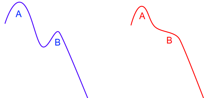
I agree that in situations as depicted in the left diagram below (coloured blue) where A is the actual hiker’s destination peak, and B is the point known amongst the hiking community as the “false peak”, it will be accurate to use your suggested tags. And I would probably add the tag false_peak=yes to signify that this point is a known infamous point where lots of hikers give up and turn back.
However, in situations as depicted in the right diagram (coloured red) where A is the actual hiker’s destination peak, and B is the notorious “false peak” - you can clearly see that it would be inaccurate to tag point B as “minor peak” because - well - it isn’t a peak at all. It is a little-known mountaineering term called “shoulder”.
If these are not peaks then inventing a new tags is better than mistagging them as peaks. If these are named places you may add also place=locality making more likely that their names will be recognized as worth showing on maps (and this does not add incorrect data!) – Mateusz_Konieczny
Ah, thank you for your view that this may be a valid case whereby a new tag is warranted, and also for your suggestion to include place=locality if the false peak has a name. By doing this, the name will be rendered, and the tag is still accurate. Cool!
Thank you for your response dieterdreist. I agree in situations as depicted by the blue diagram on the left, point B is an actual peak and we can tag it as natural=peak, and its up to the individual mapper whether he wants to subtag it as a minor peak or not.
I am of the opinion that even if both the name and elevation are unknown, if point B is a notorious point where hikers are known to turn back, it makes sense to me to tag
natural=peak (for situations in left blue diagram)
false_peak=yes
description=* (to clarify why this point - accurately tagged as a peak - is a “false” peak - just in case people get confused why an actual geographical peak is termed “false”)
or
natural=shoulder (for situations in the right red diagram)
false_peak=yes
so that hiking apps can pick up the false_peak=yes tag and render it as a symbol to warn hikers of this false peak even though it doesn’t have a name or elevation.
You could try tagging them just as a spot height - natural=peak + ele=* without a name, so anybody looking would see that they’ve reached the 1500m peak, but they’ve still got to cross the 2000m peak ahead of them, before reaching the (named) summit of the mountain at 2500m?
This topic interests me a lot, in my small region I have corrected positions, elevations and names of natural=peak.
Most mountain bodies around me have a main peak that corresponds to the wiki description for natural=peak but at the same time they have minor peaks that are recognized and have names.
natural=peak is very general and should include more subtags to correctly describe and differentiate the topography around us.
Have you considered:
natural=peak
minor_peak=yes ?
I am currently in the process of mapping a volcanic complex near me, which includes a main volcano, 3 parasitic/secondary volcanoes and 7 volcanic domes (natural=peak).
My main problem is setting the tags correct for volcanic domes, and natural=peak is too general to describe them correctly.
The seven domes already included in OSM as natural=peak have the following specification:
Lava Dome Colada type (coulée);
basically it is a geoform generated by the flow of lava from a crack. It should also be noted that these domes, although they are of volcanic origin, are not volcanoes.
If a series of subtags could be generated with community consensus it could facilitate a better description of the peaks around us.
lava domes are not considered themselves volcanoes, despite they are a specific type of geological formation that can occur as a result of volcanic eruptions.
Regarding the initial question of “false peaks”, I would say this is quite typical for mountaneous areas that you climb what you believe to be “the peak” just to find out that there is another “peak” behind. What we map in OSM are usually peaks with names, so if there is a name it makes definitely sense to enter it (no need to subtag IMHO), but if there isn’t a name it could still make sense and is up to the mapper to decide (if neither a name nor the elevation are known, I would usually not tag them at all)