what is special with railway compared to other features in OSM?
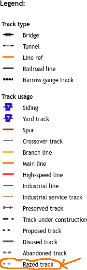
Specifically: Regarding railway, some mappers do not delete railway tracks and other track-like infrastructure like turntables completely if no indication anymore is left on the ground, but tag them as railway=razed. Andthis caused disputes:
For other features, like forests, roads, buildings, … I have not seen such disputes weather to keep completely removed features in the OSM database or not.
So, what is special with railways? (Is it only that there are quite a lot of railway-hobbyists?, or other reason?)
Nach Stilllegung, Abbau oder Ueberbauen der Gleise bitte Kanten nicht loeschen sondern in railway-disused -abandoned -razed aendern!
Here the mapper explicitly wishes that, when no remains of the railway are visible anymore (also no other traces that there has been a railway), it still should not be removed.
I actually did remove such-tagged objects recently, because I was there, and there were no remnants remaining at all. (Let’s see if it results in an edit war.)
OpenRailwayMap actually rendersrailway=razed, thus giving positive feedback to railway infrastructure where no indications of them are visible anymore:
In my case I do not want to discuss if we should delete or not old railway lines, but I wonder what is special about railway lines that this discussion only often emerges on railway lines, but not other OSM features.
Note that it is acceptable to keep such object temporary, to prevent accidental remapping. For example buildings recently demolished and still visible on typical aerials.
on the mentioned page ( Key:razed:* - OpenStreetMap Wiki ) to clarify in what kind of situation you may see a valid use of this prefix
OSM was born in the UK, a country with more train nuts per capita than anywhere else on the planet. The UK is also home to many miles of former railways that the previously mentioned nuts are interested in. As a result, the mapping of former railways is as old as the OSM project.
Hopefully some of the afore-mentioned train nuts can be persuaded to add all these old railways with all the right start and end dates to OpenHistoricalMap! It would be much better to be able to visualise network evolution through OHM / new ORM.
My understanding is that the new vector ORM (which is a parallel independent project of the original) imports its data on historic railways from OHM.
OHM’s data is independent and not imported from OSM. Just adding start and end date information into the OSM data won’t populate the OHM database. In any case, properly sourcing this information will take some dedicated research.
Most railway mappers agree that something that has completely ceased to exist shouldn’t be mapped (and hence razed isn’t really all that useful). The dispute often hinges on what counts as “the existence of an abanonded railway”. Many railway mappers are happy to take a cycleway on a former railway embankment and map that railway=abandoned because, they claim, many properties of the former railway remain even if the tracks themselves are gone. They say that this is precisely not a case of “nothing more to see here”.
That is mostly correct but not entirely; we sometimes use “razed” or something like “not:building” in cases where something has been torn down but is still visible on imagery, in order to prevent others from adding it back in. This is obviously just a temporary stop-gap that can be removed once the imagery is updated.
I map abandoned railroads, and keep (or restore if they’ve been deleted improperly[1]) “razed” railroad beds because they are the context in which subsequent development has occurred. They help answer the question “Who built those abutments?” or “Why is there a bridge there” or “What is that hump of soil?” or “Why are there abandoned rails here and there but not in-between”.
Context matters for existing railways. You can’t understand why some existing railroads are the way they are without being able to see the history of the railroads that preceded them. For example, north of Syracuse NY you have the St. Lawrence Subdivision which takes a sharp right-hand turn at Pulaski and a sharp left-hand turn at Richland. Why?
In Richland the New York Central ran nearly due north and south, with a wye connecting to the Hojack Branch headed to Pulaski. The railroad heading south was abandoned, leaving only a sharp left-hand turn from the Hojack to the north.
Plus, there is no better system than OSM for mapping railroads and sharing them with other foamers. I’ve seen people make Google Maps overlays, but the community is absent, as is the shared editing. I try to discourage such things, but give the attitude by some towards railroad mapping in OSM, I find it difficult to advocate for something hated by other people. I think “hate” is an appropriate word, given that I have seen mappers delete railbeds where they cross a road because “I can’t see it on the aerial photo”. This is particularly annoying when you can go there with a metal detector and in fact the rails are embedded in the pavement. Examples abound.
The only reason I know of to NOT map railbeds is when they were never there, e.g. in the case of unfinished railroads. Unfinished Railroads of New York State .
[1] I have seen cases of deleted railbeds where there are obvious embankments, highway=tracks, or even bridges. That amounts to vandalism.
Isn’t this true of all demolished features? Would you suggest we preserve e.g. former airports and runways (like Tempelhof and Tegel in Berlin, or Malmi in Helsinki Finland) in perpetuity with a razed=* key? How about demolished buildings and brownfields? In Central Europe, there are highways and streets that follow Roman roads. So razed=* there too?
I absolutely agree with you that bridges and embankments should be preserved (and we already have the tags for those) and with @Mateusz_Konieczny that lifecycle prefixes are useful so that demolished buildings don’t get redrawn from old aerial pictures by armchair mappers.
Traditionally, cartographers would occasionally scrawl “Dismantled Railway” across a topographical map where an earthwork or ruin was prominent enough to serve as a wayfinding landmark. Yet you’ll notice the sheet pictured in that post also labels “Quarry (disused)”. Pan one sheet over and you’ll probably encounter the ruins of an abbey or somesuch. Treatments like these condition today’s online mapmakers to accept some degree of defunctitude.
A slippery slope can complicate matters. Traditional cartographers constantly make subjective editorial decisions about what’s notable enough to depict in the allotted space. If a railway is abandoned, there’s no guarantee that maps will continue to mark it as an abandoned railway, even if it was important enough to be enshrined in national law as the basis for a time zone boundary for nearly 30 years. But in our exquisitely rational data project, we try to avoid subjectivity, which inevitably leads us to an all-or-nothing debate.
Likewise, historical rail enthusiasts also have little use for the subjective decisions of those cartographers. All the railways in their entirety are interesting in their own right, and a different subset of railways are especially notable for events that have transpired, irrespective of their durability. OpenRailwayMap targets this audience, not the orienteering club. The vector version of ORM went out on a limb and adopted OpenHistoricalMap, incomplete as it is, because a purpose-built historical map has the potential to do actually justice to this use case. In parallel, OSM can continue to cover the vestiges of past railway engineering from a modern perspective, alongside other historical and archaeological sites, for a different audience and a different use case.
Before an open-pit mine was built here, a small town with railway was existing here. This railway is utterly gone and not going to be accidentally mapped. Marking it in OpenStreetMap is wrong and should be deleted if mapped.
Here, the railway is gone without any clearly identifiable trace in terrain. Its course is known from various documents, but such historic features are out of scope for OpenStreetMap, should not be mapped.
If you want map utterly and completely and fully gone features without any trace whatsoever, OpenStreetMap is not a project to do so. We can argue how tiny traces need to remain but if you claim that open pit mine removing railway, embankment, town, soil and 20m of bedrock is still leaving traces…
I think in that case you should just add a note=* tag to the feature with now is there, explaining the origin.
Of course, as it is argued also in the wiki, if the trained eye can still see remnants of a former railway (like an old dam or ditch), it can be “allowed” to map it as railway=razed. But when there is a stretch where no remains can be seen (e.g. overbuilt by a shopping centre, a motorway built there, a coal mine, …), those parts are not eligible for any railway=razed.
Would you suggest we preserve e.g. former airports and runways (like Tempelhof and Tegel in Berlin, or Malmi in Helsinki Finland) in perpetuity with a razed=* key?
I don’t know about Malmi, but at least in Tempelhof the runway was still there when I last visited.
In Central Europe, there are highways and streets that follow Roman roads. So razed=* there too?
Roman roads often aren’t razed but built over. Personally I am mapping only those parts that still are recognizable as roman roads (paving stones at least partially antique), or also ocassionally there are short fragments that aren’t still used in the network, not necessarily with paving but somehow recognizable and with a sign. There are some historic=roman_road https://taginfo.openstreetmap.org/tags/historic=roman_road#map
but I would ask what is so special about roman roads, let’s better use historic=road with historic:civilization tags https://taginfo.openstreetmap.org/tags/historic=road#overview
Before an open-pit mine was built here, a small town with railway was existing here. This railway is utterly gone and not going to be accidentally mapped. Marking it in OpenStreetMap is wrong and should be deleted if mapped
completely agree, but open pit mines are the big exception because they leave fewer traces than a nuclear war.
These are straightforward cases since you’re guaranteed to find no traces. In typical scenarios, traces do exist, especially if no subsequent construction occurred.
I would rather map a railway that was never completed but is still visible than one which was once important and is now gone without traces. When there are interruptions (or fragments), we should not map the “missing” part.