Beyond gore chevron, sharrow, dashed, various foot/cycle crossing marking layout I know nothing and missed to find a wiki that samples the most common, 13 pages listed in TagInfo, the “Die qual der wahl” as the Germans say hitting, Wat? Pinging @Minh_Nguyen as one of the few seen broaching on this tagging to share his deep knowledge of the OSM bowels.
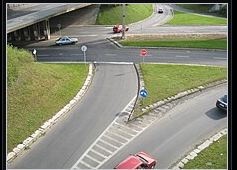
Today on bike survey, steel blue sky, cold Siberian winds, came past the ‘under reconstruction’ line end terminal for the trolley bus and noticed lots of painted traffic islands as seen in the pic below, right hand. This particular diagonal striping compared to the driving direction is widely used here so like to get the traffic_island=painted > road_marking=* right and add the selection to a JOSM custom preset.
PS Wikimedia simply refers to striping as gore but does not expand beyond showing a sample of gore chevron and another in the below without giving it as specific layout name, a picture from somewhere in Poland i.e. a design used beyond the Italian borders.
road_marking=* is a somewhat chaotic tagging scheme because the original proponents left it fairly open-ended; many who later used it didn’t really coordinate the values. Are you asking about real-world terminology to help determine a correct tag that might not be in use yet?
Terminology might differ from country to country. In the U.S., traffic engineers usually use the following terms for markings:
Pattern
Term
//////////
Diagonal
\\\\\\\\\\
Diagonal
XXXXXXXXXX
Crosshatch
<<<<<<<<<<
Chevron
>>>>>>>>>>
Chevron
The sign is located at the physical gore at the beginning of the grassy island. In front of it is a neutral area with diagonal markings. The tip of the neutral area is the theoretical gore, because it would be a real gore if a physical separation begins there.
The U.S. and some other countries typically use chevron markings for neutral areas. I guess that’s why road_marking=gore_chevron is one of the more popular road_marking=* values. But you’d need to use something else like gore_diagonal or somesuch since the marking isn’t a chevron.
As it happens, Poland is one of the countries that assign numeric codes to road markings, so you might use road_marking=PL:P-21 by analogy with road_marking=GB:1003A for dashed give way lines.
Thank you so much, in ATVIL vein and to maintain a quasi sub prefix-identifier so we all know the gist of the marking type I’ll be using gore_diagonal which the furthest majority of painted traffic islands are covered with, all ringed by a white line, sometimes a wider and broader ring as enlargement to the area. Some countries there’s a stiff penalty if it’s deemed intentional crossing rather than evading a collision.
[quote=“Minh_Nguyen, post:2, topic:127614”]
The sign
[/quote] is quite common here in a slightly different shape often at points where flare islands meet roundabout to signify there’s a choice of 2 ways to go, but then there’s a curbed obstruction of the more persuasive kind.
The italian code is IT:II.83, no Vienna code provided in the Italian road sign wiki
The road_marking=give_way I’ve been tagging for as long as I can remember on yield spots, same as the solid_stop_line. Some places refer to give_way marking as shark teeth. Human legible so no contentions with that other long running and seemingly nowhere going thread.
Over here one particular larger ‘gore_diagonal’ is middle of a junction and actually used as parking, 4-5 cars fit, front of a corner restaurant and for as long as I can remember. The cops don’t appear to care.
This reminds me that we should urgently renew the road_marking scheme before it becomes established in its current chaotic form…
Unfortunately, this is quite low on my to-do list. I’m mainly thinking of categorizing the “main values” (like stop_line, arrow, lane_divider, road_divider, road_edge, restricted, pictogram…) and using subtags for other properties like patterns/shapes, colors, sizes etc.
In this case, then something like road_marking=restricted/neutral/... (+ markings/pattern/...=diagonal/stripes/...) may be a good/better choice?
We had a debate on whether the feature should be tagged physically or functionally Talk:Key:road marking - OpenStreetMap Wiki (Alternatively it could be reserved for the traffic_sign= id to avoid the traffic_sign:id= debate now, and other solutions formulated)
Regardless of that, there’s a need to make it consistent with area:highway= at the same time Proposal talk:Street area - OpenStreetMap Wiki road_marking= vs marking= seems unintuitive, while I can realize it’s from cycleway:*:marking= / marking:*= / crossings:markings=
Another issue is what these all actually means. Distinguishing what aspects are involved, before deciding what should be chosen
I was hoping to use road_marking=traffic_signtraffic_sign=* for markings that resemble posted traffic signs, such as route shield pavement markings.
Sometimes local highway departments make other kinds of signs out of paint. For example, I recently discovered that Santa Clara, California, uses special nonstandard markings along a local bike route, including a Vienna Convention sign on the bike buffer. (The U.S. isn’t a party to the convention.)
Thanks, I left some feedback on the talk page to avoid taking this tagging question thread further off-topic. Broadly I’m very much in favor of the proposal (and am already using parts of it), so all I have is some syntactic nitpicking. We can take it to a separate forum thread if you prefer.
Top, a quick peruse ‘but’… centreline. I’ve been utilizing divider=* extensively to tag bi-directional ways with solid, double, dashed linings. In practice there’s a whole slew of those like a double centreline, 1 solid, 1 dashed to indicate who’s allowed to overtake. Even read about colour coded centre lines… I refrain from commenting on that idea (which is an inferred comment I suppose ;p).