Unfortunately this new thread has been split off from the parent so that the context (which was about the misinterpretation of access tags in some language variants in the wiki) has been lost.
in some places in the world there’s a “general right of access”, and some people there don’t think that it is important to tag what the legal access right actually is (which is what tags such as foot, bicycle etc. have historically done). In others (such as where I live) it is extremely important to record that, which is why it’s also important to record what physical access is possible separately to what is legally allowed.
It is of course entirely reasonable for a router to assume that if there is a e.g. barrier=block on a road that it should not route cars down there. That doesn’t imply that there isn’t legal motor vehicle access (the block may be illegal).
I would suggest that any barrier with access tags that disagree with the way that it is on is at best incompletely tagged - perhaps the stretch of road that the barrier is on should really be considered a cycleway (or have access tags to reflect cycle, but not motor vehicle, access is allowed.
Frustrating that this has been split when it’s core to the point of: a barrier never implies =yes by itself (without a sign).
maxwidth:physical and bicycle:physical are both documented. Maybe we should explicitly extend this suffix to all other access? This would give a quick way for mappers to eyeball the impact of a barrier without a legal judgement.
I agree with you in general, except that often a bollard or other barrier only prevents passage from one side to another, but both sides remain accessible by way of other roads or paths. Such barriers are often installed in residential areas as traffic calming measures or to discourage overflow parking. I wouldn’t object to a QA tool flagging mismatches between barriers and the ways they’re on, but it goes back to your point that a validator is not infallible.
This discussion is not about if horse=yes should be on barrier=bollard nor if it is a not idea to harmonize things over the different language Wiki’s so I still think it is a good choice.
Like I wrote, most often this is the case, but a small percentage (4.6% of all bollards) is mapped on a highway=residential.
If I understand you correctly you would not map this as a highway=residential?
That’s not a permanent barrier - it’s a rising bollard specifically to control motor vehicle access. I’d expect the bit of road with the bollard on it to have access rules for normal cars that evaluate to private or similar. I wouldn’t expect the access rules (if any) on the bollard to be different to that stretch of road.
I don’t agree in general, for the reason explained by Minh. The access tags of a barrier do not necessarily have to be the same as those of the roads on either side (if any). You can have a barrier that doesn’t let people (or things, e.g. wide vehicles) pass, e.g. a locked gate in a fence, a bollard, etc., although you can freely access both sides of the fence.
That’s absolutely not the case in the case of the posted picture. There’s a section of the “residential” road marked with extra kerbstones that is clearly not designed to be accessed by cars.
Having browsed the surroundings, I tend to agree with emvee that both surrounding roads are residential, and that the barrier was installed with the primary purpose of diverting motorized traffic around the quiet neighborhood.
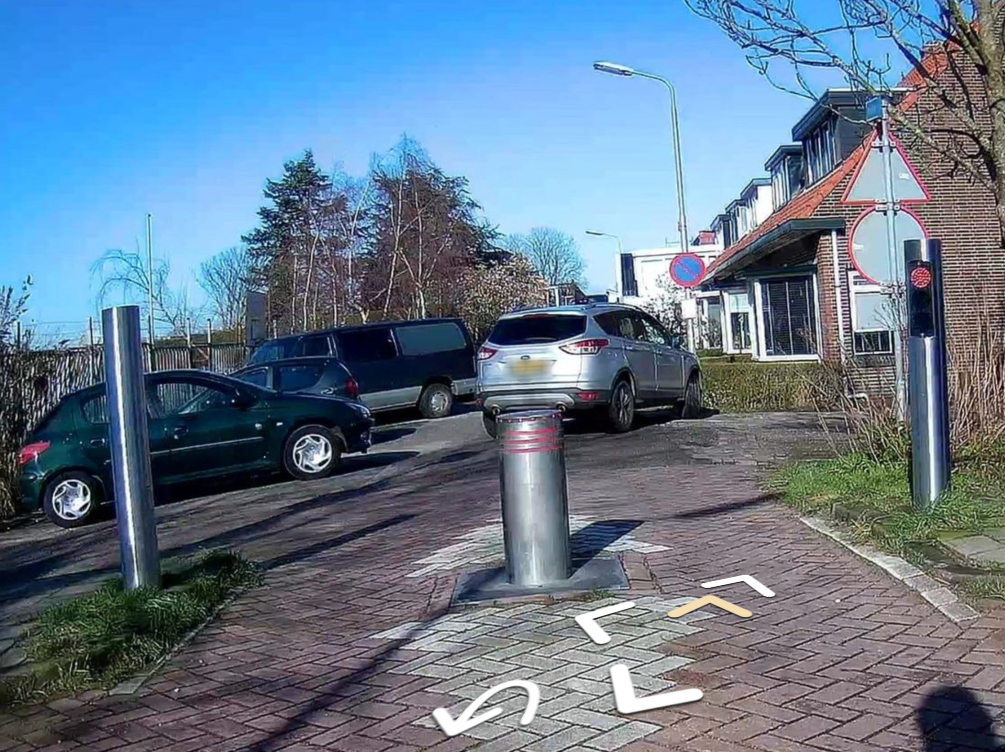
I see here a traffic sign for holders of exemptions without a time limit/restriction. From this I conclude that it is a remote-controlled bollard that can be lowered by the driver if necessary - if you have a permit. So the bollard should have an access=yes and motor_vehicle=permit.
The roads on both sides offer no restrictions for vehicles, i.e. free access. So: the implicitaccess=yes without any further restriction.
access=yes is to my opinion unneeded because by default pedestrians, bicycles, mofa’s and moped (and likely horses and motorcycles) can physically pass the bollard .
By the way, do we know if all the major routing profiles make this assumption? There isn’t an LLM-based routing engine yet – yet – so one can assume that any sentence on the wiki beginning with “by default” will be roundly ignored by the routers people actually depend on. Maybe the documentation is right by coincidence though.
Not sure what car routing against an one-way street has to do with bollards, the distance between the two points is with 26 meter way longer than 3 meter and not sure why osrm can not dream up a route.
Back to residential bollards, something to visit during the weekend?
I would like to give routers and mappers a clear set of assumptions and because that I started the original topic. routers so they know what to implement, mappers so they know what to add (if anything) on top of the set of assumptions.
I would tag this motorcar=private and not add access=yes as I see it implicit for bollards, but some people prefer interpreting any barrier as access=no and so in this interpretation you always tag positive access.
The situation is “private” if the required permit is given on an individual basis and not to everyone.
I don’t think that anyone bothered to add access tags to the bollard because it’s the road that the access signs apply to. The bollard is just an enforcement mechanism.
(drifting somewhat offftopic)
The more challenging example would be the complicated anti-terrorist moving bollards such as here (not fully mapped in OSM yet). For an entirely fair and balanced discussion of them with absolutely no hyperbole see here. There’s also a video and a picture of a dalek.
I can think of a few places where there’s a bollard between two residential roads, installed to prevent through traffic. There aren’t any signs anywhere that would legally prohibit going past. Riding past on a bicycle or motorcycle is practically possible (and I see no reason it should be illegal), driving past in a car is practically impossible (and the question whether it is legally allowed is a purely theoretical one).
When this is a stretch of road, even a short one, it can be split off and tagged as cycleway or pedestrian. When you can drive up to the bollard from both sides, a simple barrier=bollard node does the job just fine, doesn’t it? OSM-based routers will generally route pedestrians and bicycles past a barrier=bollard node that doesn’t have any access tags, and they won’t route cars past it.
Mappers then seem to sometimes add access tags like foot=no or vehicle=yes if they want to override this default routing behaviour. That doesn’t have much to do any more with actual legal access.
This is why I find it confusing when the Wiki asserts that barrier=bollard “implies” a legal access restriction.
I’m all for documenting mapper consensus and default assumptions that routers make, but there must be better ways of doing this. For example a Wiki page “routability of barriers” where we document how various open-source routers treat various barriers when they do not have access tags.
Thanks for once more writing up what is the concern, using access tag on barrier nodes.
I know Key:access has (currently):
Access values describe legal permissions/restrictions and should follow ground truth; e.g., signage or legal ruling and not introduce guesswork. It does not describe common or typical use, even if signage is generally ignored.
But I know more than enough examples that are not following this. Only looking at nodes:
What do you think on bicycle=yes/no as “access-tag” on a highway=crossing? I (still) think it is a bad idea but some people think that if things are mapped for a small percentage, it is something that should be documented.
While for highway=crossing only 0.17% of the nodes has bicycle=no (taginfo), for barrier=bollard about a quarter has foot/bicycle= (taginfo), are we going to remove all these?
information=guidepost uses “access-tags” to indicate for what type of traffic the guidepost is
information=map uses the “access-tags” to indicate for what type of traffic the map is
amenity=charging_station uses the “access-tags” to indicate what types of traffic the charger supports
highway=traffic_signals uses the “access-tags” to indicate for what type of traffic the traffic light is
Also good that have a look at the Wiki, Key:bicycle, what links here. There are 86 Tag:key=value pages that link here.
My conclusion is that the text on Key:access is no longer valid the “access-tags” are used widespread for things that are not legal but more for designate use.
I am not against such a page but for a complete solution there needs to be also a way to tag exceptions, if the “maxwidth:physical” is wide enough for a car or too small for a typical bicycle how is that going to be tagged?
I also think the use of the “access-tags” outside legal use is too widespread to “clean it up” or are there volunteers to do so?
Indeed, the first example that comes to mind for me is highway=path. This tagging scheme uses the foot, bicycle, and horse access keys to indicate what the path is designed for, with the original intention of consolidating highway=footway, highway=cycleway, and highway=bridleway.
I agree that the idea of limiting the access keys to legal restrictions is a bit aspirational. It might still make sense as a rule of thumb, for situations in which legal restrictions would be apparent. However well-intentioned the focus on legal restrictions, applying that focus to many of these miscellaneous situations would result in hypotheticals that aren’t as relevant to a mapping project.
If you want a new tag to express whether something is physically passable, create that new tag. It wouldn’t be a bad idea at all. accessible:bicycle=no - sure, why not.
But do not, repeat, do not break a well understood existing tag to communicate that. This is why consuming OSM data is so hard - because people are intent on redefining things that were settled fifteen years ago.
Changing the definition of access tagging doesn’t make life easier in any circumstance, it just means we no longer have a way to determine whether pedestrians or cyclists or motorists or whatever are allowed on a path.