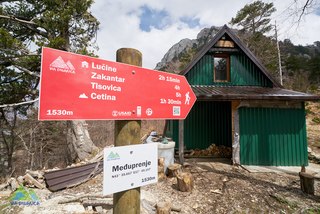
I opened this thread to talk about tagging and mapping of the Via Dinarica long distance trail that goes through Dinaric Alps. The countries it goes through are Slovenia, Croatia, Bosnia and Herzegovina, Montenegro and Albania, so it’s good to have one place to coordinate.
I got this a message from @mk2k22 which made me open this topic:
Pozdrav Janjko,
na renderima sam zapazio ovu rutu “Postojna via Snežnik to Prezid” koju ste dodali prije godinama: https://www.openstreetmap.org/relation/7389262/history, a to je u biti dio Vie Dinarice, kao što se i naveli u komentaru.
Mogu li provjeriti, koji je source za ovu rutu? Pošto gpx rute na službenoj stranici je skroz drugčiji: https://visit-postojna.si/kaj-poceti/aktivnosti/pohodnistvo/daljinske-poti/via-dinarica/?cn-reloaded=1
Također ovdje: Via Dinarica White Trail • Long distance hiking trail » Home
Inače ja sam već dodao mnoge označene rute po Sloveniji, tako da ako nemate koji drugi službeni izvor postojeće trase, ja ću promijeniti postojeći naziv rute u Via Dinarica i ukloniti/ispraviti postojeće segmente rute prema gpx-u na toj web stranici. Također bih odredio polja “From”, “Via” i “To” (Postojna, Snežnik, Prezid).
Ne znam, zašto ste stavili ref=SI-W? Šta točno znači W?
Što se tiče Network Class, tu vjerovatno ima smisla da se stavi “iwn” kao internacionalna ruta, ako će netko u Hrvatskoj spojiti rutu od Prezida dalje? Vidim, da inače već postoji dio Dinarice u Crnoj gori: Waymarked Trails - Hiking
A tu su stavili ref=ViaDin. Možda se može i kod nas onda staviti taj ref, ne znam.
Lijep pozdrav
I created the Via Dinarica White Trail Superroute, and the Via Dinarica Green Trail Superroute.
And in them there are a lot of subroutes that corresponded with trail parts I found on the website. That was 7 years ago, and now I can’t find those route parts on the website. In the superroutes there are links to websites that don’t exist any more. So now we have to see what’s the new state of those trails, are there multiple trails like before or something changed, and see how to go forward.
Here’s the Via Dinarica White Trail on the Waymarked Trails:
https://hiking.waymarkedtrails.org/#route?id=7388026&type=relation&map=7.0/44.9535/17.878
SI means Slovenia, and W is White trail. Slovenia only had one part of the route, but for example, in Croatia we had HR-W-01, HR-W-02 and so on…
I see that the Slovenian part of the route has absolutely no relation to the state 7 years ago. So the best thing would be to take this relation, delete all members, and add new ones: Relation: Postojna via Snežnik do Prezida (7389262) | OpenStreetMap
Your from, via and to sound good to me.
And about ref, I don’t know. ref=ViaDin sounds a bit arbitrary, but at least it’s a bit more recognizable than my HR-W-01. Would that mean putting the same ref on White, Blue and Green Via Dinarica?
Sure, I figured SI would mean Slovenia, but then in OSM the abbreviation for Slovenia is actually SL, not SI. At least judging from the tag used for Slovenian names where the name:sl=* tag would apply. Anyway, I think SI-W (or SL-W for that matter) seems a bit cryptic and perhaps not so useful for the end-user to really figure out that it’s related to Via Dinarica. Note that some renderers actually display the route name as per what’s specified under name=* tag, while other renders display what’s specified under the ref=* tag.
As for the different trail colors, ideally I’d specify the OSMC symbol to render the waycolor of each section of this superroute in their respective color. But the problem is that “white” is not allowed to use as per OSMC Wiki?
It’s stated in the Wiki: Please note that the color white is not allowed on the OSMC map. Not sure about this one.
Aside from the waycolor, the OSMC symbol for this route is supposedly the ‘markacija’? (Which we tag as red_round:white_dot).
About ref, I’m not sure either. ref=ViaDin does indeed sound a bit arbitrary. Unless we went with something like VD-HR1, VD-HR2, etc. (For example, Via Alpina Red is tagged as VA-R1, VA-R2, etc.; but then with Via Alpina Purple the mappers were for some reason inconsistent as strangely it seems to be tagged as VA-A1, VA-A2, etc. rather than VA-P1 as in “P” for purple. ![]() )
)
I’m not sure if this decision was made by mappers - it matches the wikipedia article about Via Alpina. Maybe it is actually signed this way, or at least used this way in some official source?
For the Via Dinarica, if there is no specific ref on the ground, is it necessary to populate the ref= field? I’ve found that where ref is left blank, at least some renderers derive a sensible short label from the name, e.g. using initials of the words in the name.
I think “sl” in OSM name: tags refers to the language, not the country.
I know there are some dedicated Via Dinarica markings in Bosnia and Herzegovina, is there no such markings in Slovenia? If not, is Via Dinarica marked with the Knafelčeva markacija, or are there other trails that go over the same trail which the markacija is for? If those markacija aren’t marked directly for Via Dinarica, then maybe remove that tag also…
I added the osmc:symbol=white:none:green_triangle::, but now after 7 years, that’s probably not a good tag and should be deleted.
I was leaning this way too, maybe just delete the tag.
Off topic: I followed those red-ring-white-dot markings on quite a few (relatively short) trails in my younger days - possibly at least one trail in every country that uses it. It has taken me 20 years to learn, through this post and the magic of OpenStreetMap, that the waymark has a specific name!
2 Likes
By the way, I’d be curious to know, how did you manage to add the whole 1005 km of the trail like that in one go?
It was just armchair mapping, although I did walk a few parts. But I didn’t know it was Via Dinarica, I never actually saw a Via Dinarica mark live. And it wasn’t in one go, it was probably a few weeks of mapping. But it seems it might be worthless now, if all parts changed as much as the one in Slovenia.