What is the correct way to tag roads located inside a gated residential community?
The majority in Chiang Mai has been tagged as [highway=residential + access=private], however, I noticed quite many have been changed or added as [living_street] or [service+alley].
This is confusing and could be misleading for new mappers.
I have also come across many [highway=service + service=alley] in rural villages while doing ground surveys and all of them were narrow roads with permanent housing on at least one side:
However, I realized I should have asked first your opinion before changing them:
Besides its main purpose to access utilities, can [service+alley] be used in Thailand for narrow roads in residential areas/gated communities or any other road purposes?
For living_street, the former discussion https://forum.openstreetmap.org/viewtopic.php?id=19316 seems like we should not used it in Thailand. By the way, stating it in the wiki is maybe too explicit, because it could be an appropriate case somewhere in Thailand, though it could be quite rare.
For service=alley, the former discussion https://forum.openstreetmap.org/viewtopic.php?id=62073 appears that we are unable to reach an agreement. I strongly oppose using this for the main access to the residence. The use, rather than the width of the road, should be used to define the highway=* tag. But if the road is too narrow for a motor car to pass, changing it to highway=path is acceptable because the use is different.
I doubt there are many actual living_streets as defined in the Wiki in Thailand. However, there are mappers in Thailand who use the tag despite the cautions in the Wiki. I much prefer highway=residential with subtags to further characterize the way in question; width, lanes, surface, max_speed. etc., if it’s located inside a gated community. Also, instead of access=private which would cause many routers to refuse to use those ways, I’ve begun to use ownership=private to tag driveways leaving the access tag out entirely. Perhaps that scenario could also be used for the residential streets within gated_communities. Many residential areas that are commonly called mubans in Thailand, I outline if possible and tag with place=neighborhood, name=*, and gated_community=yes.
Using service=ally is fine if it fits the description in the Wiki, which I agree with in general. Again, however, you’ll find some mappers in Thailand who use this tag a lot. See the thread referenced above by nitinatsangsit to get a picture of the long-running controversy.
nitinatsangsit, AlaskaDave, as always thank you for your input and the reference to the old discussions.
I would like to clarify further the perhaps misconceptions about the [service=alley] wiki page, which I believed its content may have been updated in the last few years:
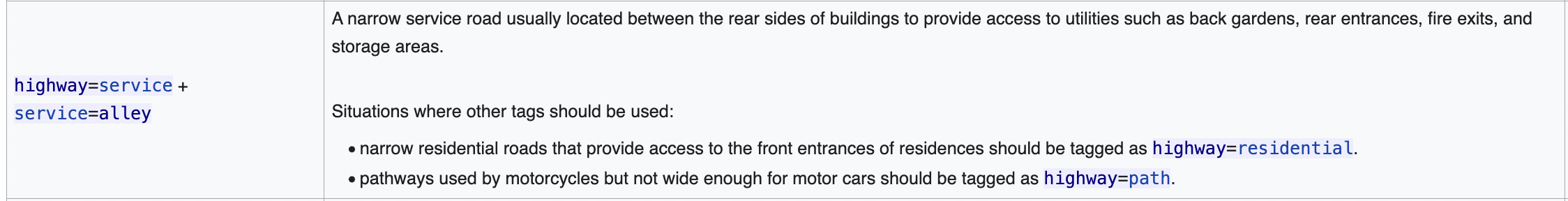
description on the right explains the main purpose of the road is access to utilities
first section reiterates the same:
second section is a special case for some medieval streets in Europe (not Thailand) where the main purpose is public through
third section is a special case for narrow alleys in the USA (not Thailand)
As far as I can see, there are absolutely no [service=alley] definitions that match a narrow residential road in Thailand, specifically these facing the front entrance of buildings.
To add to your list of places having actual service=alley ways, Anchorage, Alaska has them as well. Used for access to garages, utilities, etc. Same with Eugene, Oregon, two places I’m fairly familiar with. These alleys fit the Wiki definition perfectly.
While I don’t deny living_street could be useful in special cases (I know at least a couple of dead-end streets it could apply based on local knowledge),
using it commonly for standard, through-access, roads in gated communities goes against any of these definitions.
Would you let your kids play unattended in the streets of your Mu Ban?
Would you prevent a navigation router from reaching your house in your Mu Ban?
Is there known legislation/signage granting pedestrians priority over cars in your Mu Ban?
I’ve noticed, along with others, that you’re sticking to service=alley for minor roads that don’t quite match the current wiki definitions. I’m cool with adjusting to new ideas, but when existing classifications stray from the wiki standards, it can get lead to complications.
This not only clashes with our current wiki, but it creates confusion for new mappers. Even some Grab mappers seem now to be randomly using this classification.
When asked before on specifics, your input was a bit too vague ("I know when I see one,” “if I see a narrow road, I believe my tagging is correct.”).
So, here’s the pitch: could you please give us a strong argument for a Thailand-specific rule with clear details (like width, etc.)? The community can vote on it. Your input would be super valuable!
Your long-term experience is much appreciated, and so your help in keeping things consistent with the Thailand guidelines would be awesome. Cheers!
I thinks its back to the same old problem of me mapping what I see on the ground, and not to fit a neat definition. Reminds me of the Facebook days when everything was mapped residential because they could not or would not differentiate.
I map with a degree of routing in mind and think there is a need to downgrade narrow residential Soi’s to alleys. This at least gives routing engines a chance to differentiate. Your current Wiki statement attempts to clarify things, but I guess its just too dogmatic for my liking.
In the 15 years I have been mapping, I was guided by the Global Wiki, that allowed the general use of the alley tag. You seem to have come along of late and decided there is little place for it, and I think that’s wrong. When all streets get a residential tag, routing software will end up picking the shortest route which may be totally inappropriate.
And I know you are inviting me to help define things, but a 2 mtr wide concrete road with fields either side is probably not an alley, wheras a 3mtr road with lampposts, tight walls, and parked bike, is. Its all about judgement.
In fact I think of you every time my GPS routes me home from Maya, and it insists on taking that tiny “residential” Soi next to Lism Cafe… my Pickup just wont go round the first corner ! Now that should be an alley.
You have recently decided to change things locally, and with a few forum supporters, off you go. If you really want to help, get to grips with the Grab mappers who map every Driveway to a house as “residential”, or the mapper who recently changed nearly 1000 agricultural tracks into Service roads, which by default are paved !
Ok, so to be constructive, allow the alley tag for small Soi’s where it would be difficult for a small car to pass, and impossible for a light truck, then at least we are getting closer to real world.
Mapping is an art, and I know an alley when I see one !
The Thai wiki guidelines for service=alleyalign 100% with the global wiki, without deviation. You can review it here.
A review of the global service=alley wiki changes since 2010 reveals no mention permitting the general use of the service=alley tag for narrow roads.
In 2013, an exception was introduced for medieval European settlements, focusing on “very narrow streets running between buildings, providing public through-access.” This scenario is specific and irrelevant to urban and rural settlements in Thailand. Further details are available here.
Routers recognize lanes=1, and using highway=residential + lanes=1 has been acknowledged as a valid approach for routing. Additional information can be found here.
We can certainly reconsider borderline cases and examine mapping practices for adopting a different tagging approach for roads narrower than, for instance, 3 meters.
However, for the typical residential roads with a width of 3 meters or more, as you described above and approved below in Facebook a few days ago, I doubt you will find many “supporters.”
Ok, I hate answer that says “because I say so” or “I know an alley when I see one”. I find it utterly useless in a discussion. But that said, this answer added a lot of constructive feedback that I think is important.
I think we can all agree with Russ on the fact that we don’t want to route cars through tiny residential roads that they can barely fit through. But this might lead to an overuse of alleys where I believe most of us don’t see an alley.
We do need to solve the routing problem, but maybe there is a better way than tagging everything as alleys for the router. It might be worth looking into which tags the routers are actually using and seeing if anything applies better than an alley, or working with the routing developers on tags we think they should consider as well.
I don’t have the solution, but I just wanted to say I appreciated the last comment from Russ which highlighted an actual problem.
I agree with Johnny. I see the issue here is how we can get the router to do the right thing. Also, we should be aware that tagging for routers may be comparable to tagging for renderers, though it is not the same and is not totally wrong. Perhaps we need to do more investigation on the router side before making any changes in the mapper side. So, service=alley is not a problem, but rather one possible solution, and I’m not completely against using it. However, there might be another option.
As far as I remember, the OSRM default car profile won’t route a car down a road with less than 2m width, and it will apply a penalty for any way less than 3m in width, and for any way with lanes=1 that is not oneway=yes. The penalty assumes you can only drive at half the usual speed, which is effectively the same as saying a similar but wider road is preferred if it’s less than twice as long.
Impressive recall! I’ve begun documenting tag support for widely used open-source routers; you can find the information here: Routing/Narrow Roads - OpenStreetMap Wiki
Update: I have gathered feedback from regular members of the global community, available at the following link:
Here are the key findings:
roughly half of the participants support the tagging approach of highway=residential along with either width=* or lanes=1.
the other half of the participants favor highway=service + service=alley.
While there isn’t a decisive majority for the highway=residential option, proponents of service=alley have presented valid arguments, citing cultural differences that make it challenging to achieve a global consensus on the matter:
Naming conventions: “Alleys” is a commonly used term for narrow residential roads in Europe and other countries.
Front/rear access concept: The concept of front/rear access in housing estates is prevalent in Western countries, as seen in the Radburn design housing concept.
Medieval cities: Narrow roads are common in European old cities and settlements.
Lack of Routing support: Only OSMR considers width and lanes for routing (see Routing/Narrow Roads).
Lack of Rendering support: Most renderers do not consider width or lanes.
Additional research and discussions by @Kovoschiz can be found in the wiki, especially regarding the uncommon use of the tag in Asia or its non-recommendation in Taiwan (Talk:Tag:service=alley).
In conclusion, like many other countries, the Thailand community members will need to vote on a Thailand-specific rule for narrow roads.
Given the absence of a front/rear housing access concept in Thailand, the fact that a “Soi” is “a side street branching off a major street” and the impracticality of “tagging for the renderer,” the only relevant argument in Thailand would be the lack of Routing support.
Also, very narrow roads in Thailand resemble those found in European medieval settlements, which is already an official global wiki use-case.
Once more feedback is consolidated, including input from Grab’s Navigation team, we will propose several options with clear specifics, pros, and cons for community voting.
@julcnx Today it is not true that 2/3 of the participants support the tagging approach of highway=residential along with either width=* or lanes=1. The voting is currently 55%- 45% and just yesterday it was 52%-48%. Please give it more time to stabilize.
The “correct way to tag roads located inside a gated residential community” is mostly uncontroversial and well established as far as I know. Map them as highway=residential if they look like most residential streets, or highway=service if they are mainly accesses to parking lots or for supply or for passenger pick-up and drop-off. In both cases, also add access=private.
For true living streets, where pedestrians have legal right over vehicles at any point along the way (not to be confused with drivers’ legal duty to drive carefully near pedestrians), they can be mapped as highway=living_street where they look like residential streets and as living_street=yes in combination with highway=service where they do not. Gated communities often set their own rules and may signpost or internally rule that pedestrians have the greatest right to use some space on its ways, but as this is often difficult to verify because it is rarely possible for surveyors to enter such communities, it is unusual to see highway=living_street mapped there. But whenever confirmed, it is possible and recommended to map them as a living streets.
Since August 2013, the wiki page for highway=service mentions as an example that service=alley may be used for a “narrow road, alley or path between properties”. In January 2010, this phrase was even less rigid: “a road between properties”.