Could someone please update the map of northern Somalia to show SSC-Khatumo, a new federal state per this source [https://horseedmedia.net/somali-federal-government-recognizes-new-ssc-khatumo-administration-383891]?
to mirror https://wiki.openstreetmap.org/w/index.php?title=Talk:Wiki&curid=1907&diff=2607860&oldid=2607341 where you also posted this (have you posted also in other places)?
one would need to have 1) a source specifying boundaries of the new region 2) that source has to have a compatible license with OSM (essentially, be public domain) 3) perhaps most importantly, have a clear answer as to political situation in the region. According to Wikipedia, w:Khatumo_State was effectively separated from Somaliland, which in turn separated from Somalia. I have no idea whether the new state effectively controls its borders, or is just a proclaimed entity in the wider Somalia-Somaliland conflict
Also worth just sharing the OSMF policy on disputed territories.
Particularly:
Borders and boundaries
National borders are particularly sensitive. Currently, we record one set that, in OpenStreetMap
contributor opinion, is most widely internationally recognised and best meets realities on the
ground, generally meaning physical control.
I’m personally not familiar with the area except for the wider Somalia-Somaliland conflict (as Mateusz notes).
For clarity, it was me who made that comment on Wiki (on retrospect, I should have reposted here, but Mateusz beat me to it).
At the top level, here is Somalia in OSM. It includes the all the areas we’re concerned with here. Also, here is the disputed area of Somaliland. It is not in OSM as a country, because it doesn’t really meet OSM’s requirements for that.
However, what the question might be asking is about administrative divisions within Somalia. A query here shows some admin level 5 and 6 areas, but someone familiar with the admin devisions within Somalia might need to check.
I suspect you might have misinterpreted the question - I believe “state” here means something like an American “state” or a German “Land” - a subdivision within a country. I don’t think that this is a request to create a new “country” in OSM terms, merely to update the subdivisions of an existing one. The constituent parts of Khatumo are in OSM, so it should be easy** for someone familiar with OSM to do…
** someone familiar with editing boundaries in OSM, of course.
Not sure about person who posted it initially, but I lack knowledge to judge also this! I have no idea whether it was actually accepted by higher level government or is it unilateral. And who actually controls this area.
I wrote that, and your interpretation is correct. However, the catch is that the new (federal) state of Khatumo, with the capital in Las Anod (Laascaanod), has been proclaimed on the territory claimed by Somaliland. According to Wikipedia article, the new regional government controls the capital, but the situation elsewhere is unclear:
In December 2022, mass demonstrations and civil unrest erupted after unarmed citizens of Las Anod were allegedly killed by Somaliland’s soldiers. The demonstrations led to locals removing Somaliland’s army from the city of Lascaanood and the cities near by. The city of Las Anod is currently still in the control of the local government, who declared the region as SSC-Khatumo State and have raised the Khatumo flag in Las Anod, Sool
I suppose it’s a fair game to draw the new state borders as declared (at admin_level=4, just like neighboring Puntland), encompassing Sool, Sanaag, and Cayn regions – after all, pretty much all borders there are based on just claims and counterclaims. But general reluctance to go there is quite understandable.
2 Likes
By the way, boundaries of Khatumo as drawn on this Commons image…
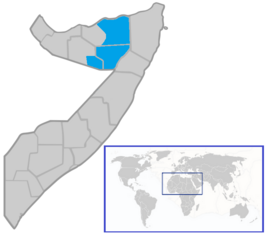
…do not correspond with the combined boundaries of Sool, Sanaag and Cayn (presumably Caynabo) regions as we currently have them in OSM. We’re left guessing even as to the proclaimed extent of the new state.
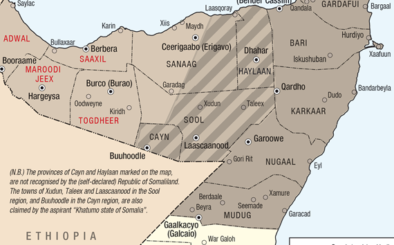
Edit: Somewhat better, but still quite imprecise image here:
3 Likes
@Brlopnnfu do you have any comment on the posts above?
Yes @SomeoneElse, @Duja , Cayn is actually another name for Buuhoodle district, a sub-district of Togdheer province. As for the blue commons file posted by Duja, the Sool borders in that file, it is an altrnative border of Sool province, and the Sanaag area colored is for the Erigabo district + Las Khorey district. Since the SSC-Khatumo state is based on the previously disputed border Puntland border, it isn’t too difficult to find borders describing previously disputed areas, i.e. te striped lines here
1 Like
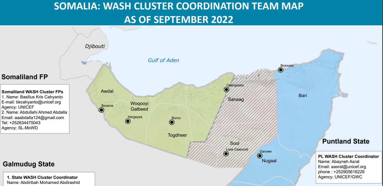
Or the striped lines in this relief web source Somalia: WASH Cluster Coordination Team Map, as of September 2022 - Somalia | ReliefWeb (better map to use)
1 Like
Alright, since I involved myself far more than I wanted, there you go…
- I did not touch the Somaliland borders so they currently overlap with Khatumo
- I drew the western border as an almost-straight line as in the map.
- As the result, several districts are now cut in half by the new boundary, notably Erigavo District and its capital.
- Overall, that means that the situation in OSM matches the situation on the ground, i.e. a complete mess.
I’ll use this opportunity to disclaim any further responsibility. ![]()
2 Likes
@SomeoneElse @Duja Great work, and I appreciate your effort. Although I want to add that other Federal member states of Somalia currently have dotted lines marking their state as seen here: Somalia - Wikidata as well as a lavender colored line as seen here: Somalia - OpenStreetMap Wiki Would you please be able to do the same (dotted line / lavender-colored line) for SSC-Khatumo, since its a federal state now?
2 Likes
There is only one central OSM database, where I’ve just entered the state boundaries. However, there are hundreds of websites and applications which display (render) those data, and many of them have considerable lags, and we do not have direct control over them. I would not be surprised if it takes a month to appear on low zoom levels in Wikidata maps and OSM carto.
3 Likes
Map layers that use OSM data do so at their own speed. The map tiles that you see at OpenStreetMap will update regularly. Other maps, however, may not. A phone app may perhaps only update when you install the next version of the app.
The two maps you link to are both wikimedia maps, so although OSM data will have been used at some point in the past as the basis for them, there’s no guarantee when (or even if) they’ll get updated.
2 Likes
At some time last year I raised a question in the Kartographer forum on the German wikipedia (in German of course). I was told Actually, the map data is updated every few hours - but sometimes it were not fully functioning… ![]()
I don’t know the current status of that issue…
1 Like
@Duja @SomeoneElse Thanks for informing me on the status.
@SomeoneElse @Duja I believe that the Somaliland border should be altered because the United Nations rejects the notion that Sool is a part of Somaliland Security Council Press Statement on Situation in Somalia | UN Press, note the line “immediate withdrawal of Somaliland”; the Somali government likewise recognizes SSC-Khatumo territorial claims over that of SL Somalia: Feds to work closely with SSC-Khatumo administration – Somali Dispatch; the Somalia & SSC-Khatumo flags currently fly over Sool’s main airport, https://twitter.com/Axmadmawlid/status/1713843043558703235 Since it would be considered undue weight to continue to display the old border when the international community, Somalia and locals are in unanimous concurrence that Sool, east Sanaag and Cayn are outside of SL jurisdiction, could someone please change Somaliland’s eastern border?
How OSM handles these sorts of things was mentioned above:
“what the UN thinks” isn’t always relevant, as it has some very odd views on what is / is not a country (e.g. Taiwan; see also here).
1 Like