Hi all,
I’m wanting to totally stop using Google tools and I managed to replace all BUT Google Maps. I use Organic Maps from time to time when I cycle, but when I’m driving to a town I don’t know, I prefer to use GMaps as it’s more reliable with the house numbers.
In my town, there is very few properly marked houses, and most of them done by me. Would be possible to automatize the process by using some sort of public API?
I found this (AdressBase Ordnance Survey website here) - can somebody make any sense out of it and knows if it could be implemented into OSM project?
There is no open source of addresses in the UK outside of OSM and a few registries that incidently contain address data (despite lots of weasel words the OS data isn’t open). For now surveying them yourself is your best bet to improving the situation.
PS: OSM-UK was working on a larger address surveying initiative 2 (?) years back, but that seems to have fizzled out.
Oh that’s a bit disappointing…I can try my best with my area but it’s just a shame you can’t rely that the navigation will find an address if you go to town over.
Mapping residential addresses is time consuming, and you will usually find some that you cannot easily verify.
Businesses are much easier as they have an interest in being found.
When you say 'pulls business names are you talking about OSM?
I do wonder about the real value of residential addresses, once you have navigated to a street it doesn’t take long to find a number and unless you are someone like Amazon who will have licensed closed data, most of us don’t do this very often.
I, as I suspect do most map users, often use poi data from OSM. I often want to find a pub, hotel, restaurant, camp site, supermarket but have very little need for residential addresses and a couple of minutes once in the street isn’t a big issue.
Recently needed similar information about house numbers (strictly speaking addresses) in my area to plug gaps in canvassing data I was processing.
There are several web sites around that list addresses for Council Tax purposes. The raw data these sites display is covered by a UK government licence. However, I found discrepancies between the various Council Tax sites with some listing a few of the new properties and others omitting existing properties. There were inconsistancies between the exact form of the addresses. A combination of all of them provided me with upwards of 95% coverage of addresses.
Do a DuckDuckGo search for
council tax rates
or similar terms and you will likely find several of these web sites most of which let you download relevant listings for a particular area, typically by council of Parliamentary constituency. Look out for web site in the .info domain.
Some map sites get postcodes wrong! They use bounding boxes from Boundary Commission data but the boxes do not always align with the road. Found this out the first time I tried to use these boxes as my own residence was put in the wrong postcode! And not even one that was adjacent rather it was 400 metres away and require crossing an intervening railway track.
All of these are not permissible for use in OpenStreetMap: nearly all will be sourced from GeoPlace under heavily restricted licences.
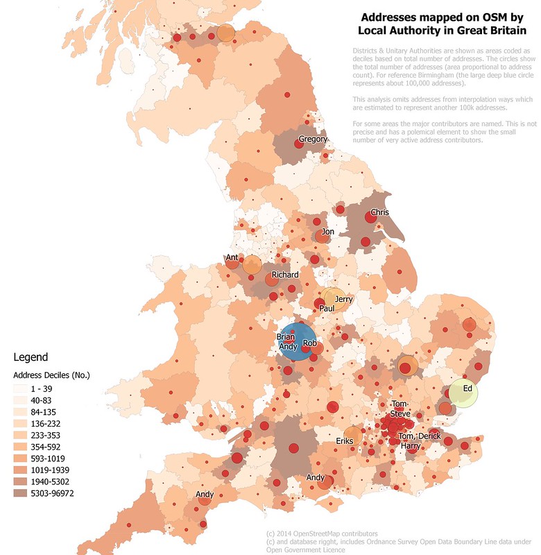
The UK has a long history of obstructing the idea that addresses should be open data: for instance creating disposable address data for the 2011 census cost millions of pounds. The overview of address data written up in The Economist 9 years ago is still a pretty good overview, both for the UK and internationally. My own write-up of the same event is here. We have perhaps 10% (3.5 millionish) addresses in the UK, but they are still concentrated in the same places as the map I prepared in 2014:
If this is political canvassing I would put the effort into collecting address data and adding it to OSM. It’s a particularly good use case where addresses can be very useful at a local level without needing them to be collected nationally. We have quite a few active members who have stood for parliament and local councils and a number of these have mapped addresses to assist their campaigns.
There are some open data which can help:
ONS publish lookup tables from UPRNs (unique property numbers) to various administrative geographies, including postcodes.
ONS and OS (CodePoint Open) also provide open data on postcodes. This is fine most of the time, but the UPRN-Postcode lookup helps resolve awkward cases).
Companies House & Food Hygiene open data provide around 1.5 million addresses, but are either not geolocated (former) or only geolocated to postcode (latter). Companies House data may have been collected over a long time and there may be many, many different forms for parts of the address above street (for instance Broughton in Nottinghamshire contiguous with Ollerton has about 47 different variants).
Other local authority local data. Some local authorities may make info on a range of things available as open data. Basic data on planning applications is one which can be useful.
All of these can help, but actual checking addresses in the field is still necessary. Many streets are quite straightforward and once a few have been checked one sees the patterns which enable sensible guesstimating for nearby streets (things like is there a #13, which street to houses on corners belong to, how are postcodes allocated). Anchoring the address schema by just doing major roads can help a lot as it will tell you where the low numbers start.
Not sure how much of the council tax data is covered by it but all the sites claim that (the UK’s) Open Government Licence applies to the listings. The licene terms include
You are free to:
º copy, publish, distribute and transmit the Information;
º adapt the Information;
º exploit the Information commercially and non-commercially for example, by combining it with other Information, or by including it in your own product or application.
Just a note that one has to be careful with sites that re-use data from elsewhere. The OGL3 licence (which is compatible with OSM) may only apply to data produced by the site, and not to data pulled in from elsewhere (which the address data is likely to be).
So then you have to find the source and the licencing of that pulled in data. Either by digging it out or contacting the website owners.
Over the last few months, I’ve been working on improving addresses in Newham and Bicester. It’s fairly time consuming and works in three stages.
Trace and split buildings using Bing aerial imagery and the OSMUK Land Registry polygons
Find the building polygons which contain only one UPRN from OS Open UPRN and link this to the postcode from the ONS UPRN Directory (ONSUD). Nodes at the UPRN co-ordinates are then manually conflated with OSM data in JOSM. For buildings capable of receiving mail, addr:postcode and ref:GB:uprn tags are added and addr:street can usually be determined and added. For buildings which do not actually receive mail, like blocks of garages, substations, etc., I only add ref:GB:uprn (the postcode for these appears to be the nearest addressable object and is often on the “wrong” street).
Use StreetComplete/SCEE to capture addr:housenumber and addr:housename. This tends to involve lot of very slow walking, particularly where numbering schemes are inconsistent. Somethimes you can capture the odd house number from Bing Streetside or Mapillary, but the imagery is often not sharp enough to be of use. (For business names, those sources can be very useful, although Bing is usually of uncertain age).
Any iOS equivalent apps? Much as the features of StreetComplete or SCEE look useful I work in an entirely Apple ecosystem and these apps are not available to me.
You mean Go Map!!. It’s a full OSM editor, so more an equivalent to Vespucci than StreetComplete/SCEE. I’ve not used it myself, but I know people who use it exclusively (and do a good job with it too).
We have a long history of ostensibly open data being encumbered by other data where the rights are owned by someone other than the organisation releasing the data. Notably this included the Land Registry Prices Paid (LRPP) data which included about 40% of UK addresses (non-geolocated).
If there was a magic bullet for addresses we’d have identified it by now. The ODI initiative which had substantial funding for an initial phase (IIRC £500k) started down that route, but once the LRPP data was gone their approach was somewhat damaged. More significantly was the risk of legal action from current owners of address data: this affected their ability to obtain professional indemnity insurance.
Owen Boswarva blogs regularly about open data issues in the UK, and is probably considered the expert in the field… He has covered address issues many times. This is his most recent post on the subject.
Driving past slowly with a gopro doing a time lapse out the window can be good too. Unfortunately doesn’t work well for those houses that seem to aim for as little contrast as possible on their signs.
There’s an unlisted beta of a MapComplete theme for British addresses, but I don’t think it’s ready to be the go-to companion for address surveys. Info here.