Traffic islands

Hello fellow mappers!

I have been mapping traffic islands for some time now and while most of the time it is pretty straightforward thing to do, I still managed to find myself in few places scratching my head. I need a little help on how it should be done in few specific situations and prehaps even standardize it for the future. I have been mapping traffic islands as an area with few occasions as a point.
Traffic island wiki: Wiki

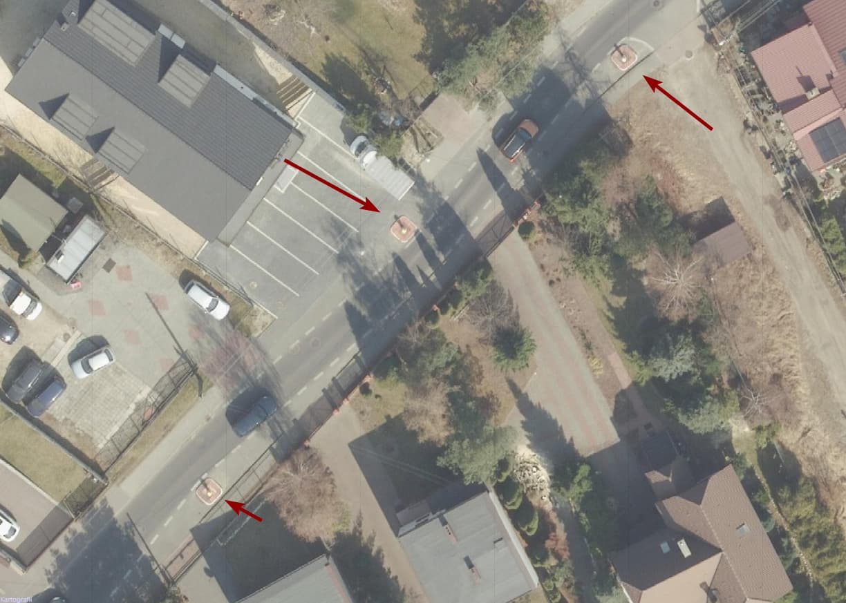
When there is a highway that is pretty wide and there has been mapped one-way separate paths (primary roads or secondary roads), its easy to add a traffic island or something different like land_use=grass etc. This often depends on the level of the highway e.g. if its primary road, secondary road, tetriary road and so on. In case of primary and secondary road, usually paths are mapped as one-way and separated from each other. Hence why its so easy to map traffic islands between those one-way paths as an areas. Adding traffic island as an area and also outlining it with the curb is straightforward and simple.
For example this traffic island: Area example

Same applies to tertiary and and other roads if they have been already mapped as one-way separate paths. This happens usually on big crossings or roundabouts and then traffic island is added between these paths.
For example: Area example

Now for the traffic islands mapped as a point.
When there is no crossing and the highway is mapped as tertiary or some other minor road, simply adding traffic island as a point is already good enough and works perfectly well. Also aligns perfectly with the wiki of traffic island. The reason for that is tertiary and other minor roads usually are not mapped as separate one-way paths. They are mapped as single two-way path. And because of that using traffic island as a point, its perfect.
Here is a good example: Point example

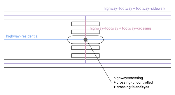
Here is an example of traffic island as a point mapped as crossing:island=yes: Crossing point example
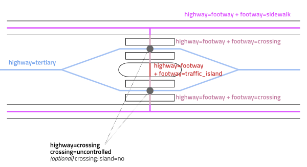
It is also reasonably simple situation where there is not exactly a need to map traffic island as an area, in this case even refugee island since there is pedestrian crossing. However, there still could be mapped traffic island as an area putting little bit more effort into it and since its a crossing, it wont be looking like an eyesore.

And then comes the part where I am scratching my head if its wise to map traffic island as an area. Basically should we go the “overengineering” way in such situations because going such way means its micromapping with its own problems.
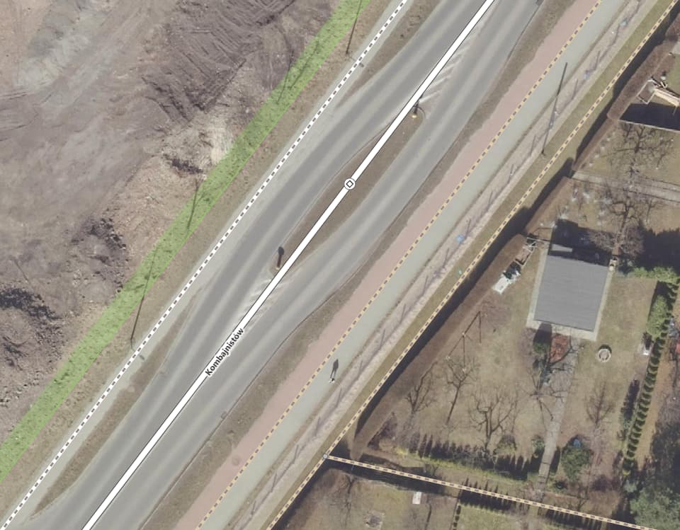
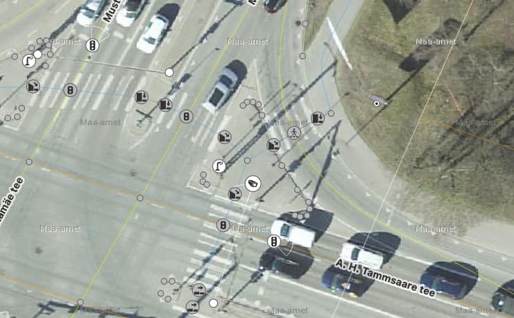
This is the problematic example: Example in need of help

Example has a pedestrian crossing with refugee island aka traffic island. I already have mapped some time ago traffic island as an area and added curb for the islands outline. Since there is a crossing, I have added crossing:island=yes for the crossing point. Also, the crossing as a way also has crossing:island=yes tag because the crossing way has not been separated yet.
But this kind of mapping is not great if the ways have traffic island already tagged and then adding area feature right on top of these ways. In this case tertiary road is going right through the traffic island which is not correct. Since it is a tertiary road, it does not usually follow the rule like primary and secondary roads follow - map them as separate one-way paths which on its own is also dependant on the situation.
For this example, should I separate the tertiary path creating separate one-way paths around such traffic island or remove the traffic island area leaving only the point and way tags of traffic island as crossing:island=yes?

The reason for such question is simple:

  • If separate ways on each traffic island, then one massive chain-like path happens which in my opinion does not feel not great. And it the road itself is very wide, then the chain loops become also very big which in turn on map will look more like many small roundabouts rather than straight road.
  • If separate one-way paths for the full length of the road, then lots of extra work uphand while the amount of traffic islands on such road is in reality quite small which in turn creates extra work for maintaining particular road data.
1 Like

Hi,
I think maybe you should create this topic in General talk or Help and support for better visibility as it isn’t a particularly Estonian issue.

On the topic I agree that both the “chain” and making two one-ways don’t seem like a good solution.

Looking forward to reading views on this as in recent (4-5) months a 4 way was split with the most eastern lane turned into a kerb separated cycle track and in the second phase traffic calming island were constructed at marked crossings with the identical paint job to convert the center lane of the 3 remaining, so now 1 north & 1 south lane is left. Only briefly with paint a 3 lane section inserted to allow a left turn.

Looking up the wiki (last edited Oct 2023!) how to do this never had come across islands mapped as nodes and drilling in a part where is says “there’s no consensus…”, it did not appeal to me to map the island outline + the island nodes at first but there’s something to be said for it as it does notify the router there’s a traffic calming element in the way. At any rate, mapping a road through the mapped island area (area:highway=traffic_calming) with protective kerbs one even got railing for the pedestrians not to take a shortcut feels like routers would have an issue with getting past.

At any rate, mapping a road through the mapped island area (area:highway=traffic_calming) with protective kerbs one even got railing for the pedestrians not to take a shortcut feels like routers would have an issue with getting past.

If you don’t connect them with common nodes, then it shouldn’t be a problem for routers. May trigger validation warnings asking to make a node at intersection or separate to different levels though.

It looks like there isn’t a good solution, the practice of not creating two one ways without physical separation contradicts it if you don’t want ugly split around the island and IMO it’s very ugly. You can map highway as an area, but the centerline still would be rendered.

I think that the way it’s done today in the example is ok. Both drivers and pedestrians will have their traffic island with traffic lights, and wheelchair routing will have its curbs.

The area of the island is micromapping which isn’t super useful. Do any data consumers use them? In the same way highway could get an area too, then consumers which care about areas would know what’s going on.

I disagree that this is a good example. Here the traffic island IS NOT used to ‘calm’ the traffic, thus I think it should NOT be mapped using ‘traffic_calming’ tag.

This example is better I think of what should be tagged with ‘traffic_calming=island’. Node: 5542376593 | OpenStreetMap

Maybe area:highway=traffic_island could be used instead? It’s from an abandoned proposal, but has 17 766 usages.

1 Like

Finally sat down and did the 3 lane section part with the turn:lanes and saw I had already marked the crossing with crossing:island=yes tag wondering if that’s also telling the motorized traffic there’s an traffic_calming island in the way. The crossing:island wiki has this fine graphic of how it’s seen


There no separate ways mapped by the letter for northbound and southbound, the ‘alternatives’ section also including a graphic of the ‘very ugly’. It IS.


So, the question left for me is if crossing:island=yes on the node where crossing and road cross is sufficient a notice for car etc router.

I disagree that your example is traffic island. I would say its more of a chicane because its forcing a driver to physically change trajectory of the travel meaning you have to turn your steering wheel to drive around such feature. Off course we can argue that it is also a traffic island but in this particular case its more of a chicane and should be mapped as a traffic_calming=chicane.
However, wiki for the chicane claims that chicane is a deliberate sharp curve you must drive around. Emphasis on the word sharp. How sharp it must be before it is considered a chicane instead of traffic island?

Looking at your examples I would answer that yes it should notice. However, I am not sure that a router will notice a traffic island or more of a refugee island in this case. Depends on the router I guess. OsmAnd for example does notify driver about the crossing if its up ahead which in your example is already very good, however the notification happens even if the refugee island is missing from the crossing. But I have yet to hear OsmAnd to tell about traffic islands of any kind while on the roads I have been.

This is a chicane:


Usually two or three islands placed alternately on the sides of the lane, which you have to slalom around. Usually found on oneway=yes roads.

traffic_calming=island is meant as a way to mark a single island in between lanes that is used to calm the traffic, usually found on lanes=2 roads.

Yes - the outcome is similar. Yes - you have to slow down and you have to slalom around the obstacles. But the structure itself is fundamentally different.

I can tell You that OsmAnd warns about any traffic_calming=* tag (source)

Great! That means I just have just been on the roads where traffic island has not been mapped visibly for the router.

Sounds more reasonable difference to me. But coming back to my example you disagreed initially and looking at Wikipedia description of what is a traffic island, we still have a muddy water and no clear path when we should use traffic_calming=island in that particular example.
My reasoning why its a good place to place a traffic_calming=island point is that there is a turn to the right toward the grocery shop. Because of that turn, the traffic slows down there and in order to prevent nervous drivers from overtaking slow turning vehicles from the left side by using the opposite lane essentially risking a head on traffic accident, the physical separator was placed there, calming the drivers and forcing them to rethink of such dangerous maneuver there. By this reasoning, it is a traffic_calming=island where overtaking slow drivers on the turn is not allowed by the physical separator.
This reasoning is reaffirmed with Wikipedia - some movement is prevented totally.
A quote from Wikipedia:

Blockquote
Traffic islands are often used at partially blind intersections on back-streets to prevent cars from cutting a corner with potentially dangerous results, or to prevent some movements totally, for traffic safety or traffic calming reasons.

Area:highway=traffic_island could indeed be used to map other island-like features that do not act as a traffic calming but act simply as a routing or dividing feature of traffic lanes, e.g. right lane turns right but has separate lane for it on big intersections.

1 Like

I’m thinking about the traffic_calming=* tags so that they should have something in common. That is in my opinion the reduction of speed. Traffic islands that solely route traffic do not do that.

The island in your first example doesn’t make any car go slower, it’s for safety of the cars that would like turn right into the grocery from the ‘middle lane’ (which is there to not block the traffic for the guys that are coming from east to west. Cars coming from west to east are routed by the island to not go ‘head on’ the cars on the middle lane.

But yes, it’s pretty muddy water. :confused:

Please check out also What's the traffic_calming=island area? - #20 by IreuN

I would not reduce the island definition to single restriction/definition that is reduction of speed. Wikipedia article about traffic island I linked has much wider meaning for traffic island and is not restricting it to speed only since calming the traffic does not imply the reduction of speed. Calming the traffic also could mean directing drivers or restricting drivers to certain movements, rules, etc even without reduction in speed.
For the example to support such reasoning I have to resort to speed table. Speed table is also traffic calming feature. However, depending on how its built, it may not reduce the speed of movement at all. Usually speed tables are built according to roads speed limit e.g. 50kmh road has a speed table and you can safely drive over it with 50kmh speed as well as slower speeds. You would need to reduce speed from 90kmh to 50kmh in order to safely drive over the table but its calming only if you are speeding over the speed limit. So, in normal circumstances, it would not calm anything because its been built to the highest speed limit of the road with intention to not restrict normal movement, only restrict overspeeding situations.
Same is with traffic islands. Not all traffic islands are build to restrict speed, some are built for routing, some are built for limiting movements toward some directions and some are built to reduce the speed. All of this is also mentioned in the Wiki’s article.

After reading this and all the other stuff I have read about the traffic islands and proposals about them, I feel that we are trying to redefine what traffic island is…
Fortunately there is area=yes;surface=* as a last resort besides other features like landuse or area:highway in case of mapping micromaping until agreement has been found. But that still leaves the muddy water of points…
Personally, I would stick to the Wikipedia definition of traffic island and would not mark traffic island as a traffic_calming=island where it is only routing the traffic e.g. right lane turns right like the image example I gave.

1 Like

I’m not trying to reduce the definition of ‘traffic island’. I’m just stating that not every ‘traffic island’ should be called ‘traffic calming island’ and should not be tagged with traffic_calming=island. In fact that’s what Wikipedia says:

Traffic islands can be used to reduce the speed of cars driving through, or to provide a central refuge to pedestrians crossing the road.

That means than not all ‘traffic islands’ serve the purpose of slowing down cars. And I argue that traffic_island=* tag should be used only when that purpose is served. That’s all hah

Kind regards! I think enough was said about the topic. :slight_smile:

1 Like

Recently noticed that traffic_calming=island tag in ID is now properly called “Traffic Calming Island” while if you use area:highway=traffic_island does not change to “calming” anywhere. Since I am using ID as per my needs on the fly, I like that change. It is much more clear now what is meant with just simple traffic island where pedestrians can walk to cross big crossings or that long separating island between two 2-3 way highways and what is meant with actual calming island where you have to reduce speed unless you want to take off the landing area called streets using traffic island as a ramp for taking off. Furthermore I agree now that traffic_calming=* should imply that the calming feature requires you to reduce the traveling speed.
Therefore I would use traffic_calming=island where its actual island as you have shown in the example you have corrected me before in this feed while using area:highway=traffic_island would be using where its simple island: pedestrian island for crossing, ways separating islands, simple islands dividing turns/turn lanes, etc.
Area:highway=traffic_island, despite its abandonment, I would say is exactly what we would really need.
Even more so, reading through this feed, I noticed that I somehow mistaked area:highway=traffic_island for =traffic_calming which was plain incorrect and hence the confusing with area:highway=traffic_island and traffic_calming=island. Now that its cleared up I see that we do have two distinct traffic islands, one is calming the other is just island for various purposes. And area:highway=traffic_island do not contradict with Wikipedia’s link I gave.

Would that be more suitable now or there could still be something added like some different usecase or some exception? Otherwise I would start with fixing the mess up a bit where I am local.