My work within OSM has been very heavily focused on Bike-Pedestrian-Disability infrastructure, hereafter referred to as simply “bike-ped” for brevity sake. I can see a number of ‘opportunities’ with the current state of this type of mapping and I’ve been trying to wrap my head around how to do a macro level proposal, similar to Public Transportation v2 back in the day to not just discuss and/or propose a single tag but system of tagging for bike-ped as a whole. I don’t want to get too much into the weeds on what all I see but here are some highlight of the bigger picture issues that I think need to be addressed as a system not individual tags.
(Note: I’m North American so my descriptions will be from a right-handed traffic perspective if you are from a left-handed traffic perspective please keep this in mind.)
Bicycle-Pedestrian Lanes
Specifically ones that share a common way as a road and are “between the curb” of a right of way. Cycleways as part of roads kind of feels like an after the fact “add-on” and not given the same type of consideration as traffic lanes for vehicles. Hence why they are excluded from lane number counts and can’t just be treated as traffic lanes that where vehicles are the restricted access type for the lane. Instead cycleway:left/right/both are the way to specify that a road has a bike lane.
This already causes our first “assumption” led opportunity. That a bike-ped lane can ONLY ever exist at the side of a roadway. The issue here is that bike lanes exist in the middle of roads and at places like approaches to intersection a right turn lane might cross a bike-ped lane to that the bike-ped lane remains to the safer
left hand side of right turning traffic. Already the side of the road assumptions fail bike-ped infrastructure mapping.
Next, the directionality of bicycle lanes or the use of lanes on sides counter traditional traffic flows makes the above issue even more pronounced. The first attempt to address this came with cycleway=opposite_track and cycleway=opposite_lane which already has so many tagging issue on their own because it’s making one tag represent two things. The first being if there is a form of physical separation (track) or not (lane) combined with the directionality “opposite_” although one other tag stuck with one but dropped the part that indicated the type of cycleway only to focus on directionality. I’m looking at you “cycleway=opposite”, you know what you did. So now we have cycleway=track for with the flow of traffic and cycleway=opposite_track (for against the flow of traffic). However, many bike-ped lanes are bi-directional on one side of the road. This lead to some people just giving up and recommending that if a lane is bi-directional just make it it’s own lane or use oneway:bicycle=no, which is really only intended to override a oneway road not to indicate bi-directionality. (Note: This isn’t just anyone making these recommendations this is PeopleForBikes one of the two lead bike-ped city rating platforms and the Bike Industry’s lead advocacy group.)
Since then the tag cycleway:left/right/both:oneway=no has come about which will never had a yes that wasn’t already assumed which fills this gap but not before a lot of “messes” have been made with people splitting out bike lanes just because of the lack of a bi-directional solution for a decent period and people not switching over.
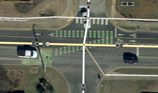
The handedness of bike lanes also causes problems when they switch at intersections. For instance at the intersection below there a bike lane that is bi-direction on one-side switches to be bi-directional on both sides causing a weird. To be honest this is a tough one to even identify I’d call it maybe a sidewalk that crosses an intersection diagonally from an ‘advance stop line/bike box’ and a Bike lane.
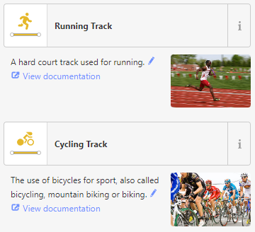
Coming back to something I mentioned above as a matter-a-fact is that it’s understood that track means lane with separation and lane is a lane with no separation. Well look at how OSM iD iconifies track as a cyclist with a specifically racing helmet followed by a runner running on a sports track. This are very different visuals to someone biking in a “bike lane” that happens to have separation. This issue is complicated a lot more in a English speakers separated by a common language sort of way where British English has a meaning for a track more akin to a ‘track of land’ than most American English speaker would ever consider. The thing is bike routing very much depends on cycleway=track for weighting routes so this might be something that just requires more documentation.
As an aside there is also a proposal for Key:separation that can get into more about the type of separation that exist and on which side including buffer space but it’s been stuck for a bit but it also shows some of the issues with handedness getting stacked like cycleway:right:separation:left=vertical_panel which means, “the cycle lane on the right side of the road has vertical panels on left side as a barrier.”
Bike Lane & Side Path Interaction point
For this section ‘Side path’ simply mean a wide multi-use either along a road but on a separated surface from the road, typically outside the curbing if there is any, and not including sidewalks.
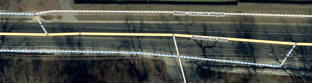
When a bike lane become a side path or visa-versa you can get some interesting “jump” segments from the roadway center-line to the side path centerline. Like this one where the bike lane technically ends then there is a crossing and the side path then starts. From the entering road perspective through a cyclist could turn left to get direction on the side path or they can enter the road at the point that the bike lane tagging starts.
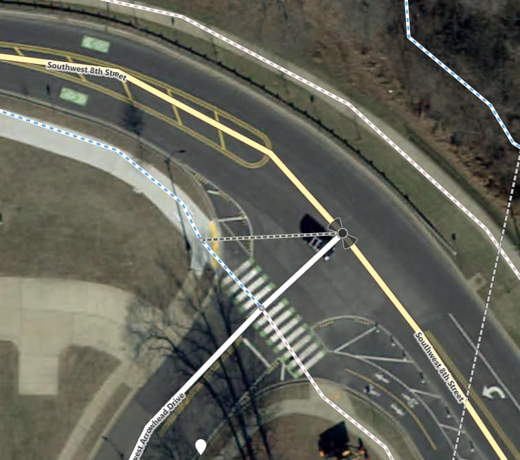
Or a different example where heading west you can jump off and join the side path OR continue onto the road through the stripped lines and join the road as a shared lane. Heading east traffic needs to be on the south side an must merge in but pedestrian traffic can head east on the north side and then merge into the sidewalk.
What is missing in all these places is something akin to the restriction relationship of traffic which has no left/right/u turn and a long list of exception. However, how to exit traffic and get onto a side path is fuzzy in a lot of place because the complex interactions that happen at intersection. The big gap from a routing perspective is clear communication of how to make the transition like restrictions do for roads. A side path could merge with a road that has path on both sides but in reality that connection really only connects with the lane on the same side of the road not the opposite side of the road but how would you be able to tell this? You can’t really. How about the earlier advance stop line and diagonal cross walk how is that to be communicated in the single node that contains the switch from bi-directional one side to bi-directional both sides? You really can’t right now! There is more to this but this is enough to get the gist.
Side Paths to Roads
This is a scenario I don’t think we really have a grasp on and I actually thing the new proposed tags don’t solve but further divide on. This is how do you associate a side path with a road there is a ‘de facto’ cycleway=separate which indicates the road has a cycleway but it’s mapped separately. (As discussed earlier this could be a bike lane that was mapped separate because a bi-directional solution didn’t exist or a sidepath this tag doesn’t say what the exists only that there is supposed to be something which couldn’t be more vague.) There likewise is a proposal that is for Key:is_sidepath which is trying to do a similar only it is added to a highway=cycleway and has added keys to reference the road to which the cycleway is a sidepath of. The opportunity I see with these associations is they are two sides of the same coin and maybe they need to be a relationship with roles vs. tags. That said I don’t see good guidance within the OSM Wiki on how to document roles within relations.
Recreational Rural Roads (the three Rs)
I also live in a community with strong gravel cycling roots the OSM rules around only mapping what is on the ground though has somewhat made it difficult to map good gravel routes in a way that they are usable by bicycle routing apps based on OSM. That said the area has piloted a Recreational Rural Roads plan that actually has recreational standard MUTCD compliant signs and I’ve been working on what tagging these looks like and the opportunities of getting good routing working for this type of cycling which merges roads and cycling in a way quite distinct from road warrior cycling one paved typically road traffic roads (although gravel looks for safe highway crossing routes like shoulders so that is an aspect).
What would a big picture proposal look like?
I’m kind of looking a Public Transportation v2 as inspiration where there was a top down view of for instance a bus route with the road, stops, platform, stations, etc. combined a bit more with a “complete streets” model that starts possibly with the existing but not fully used Relation:street and getting more into roles like street, side path, crossing, pedestrian, etc. Then tags for the name of the street and maybe information around the relationship between the street and street-adjacent items. This seems to be a work in progress under Proposal:Relation:street that already has a number of the above roles detailed.
The next tier I’d like to figure out is something akin to Key:restriction or expanded upon this model to cover the side path and bike lane interactions. This also might pull in aspects of Relation:manoeuvre for prompting bike-ped user about how to navigate intersections. This also might be need even on bike lane-to-bike lane where switching sides of the road occur or points where bike lanes start and/or end along a road for what merging from and two lanes and traffic looks like.
I could get into more but I think is sufficient to lay out my bigger picture vision for the type of opportunities there are and a system not a few tags to pull the existing and new tag uses together.
I’d like thoughts and opinions for what this would look like from anyone else here so I can project plan a path for progressing this.