Thailand - Connect Isolated Highways

Hello Thailand

I am reaching out to you this time to share a new MapRoulette challenge for connecting Isolated Highways. The leads were generated based on road classes and their connection to the rest of the network distributed in many location

For more information about our data improvement activities in Thailand, please check out our GitHub page.

Please let me know if you have any concerns or feedback. Happy editing!

Salim Baidoun

@sbaido we had already a discussion about this topic.

Yes, connecting these isolated highways would be useful, but having someone randomly on the internet guessing their connection without local knowledge is not.

While a few might be obvious mistakes, the reason why many of these segments are isolated is that they were added with imagery and it’s impossible to identify their final connection to the main network without local knowledge.

Examples:

  • MapRoulette (gated community under construction, walls will be erected with a single entry/exit, no way to know)
  • MapRoulette (building obstruction on both side, no way to know)
  • MapRoulette (connection under trees, no way to know)

Public MapRoulette challenges are targeting worldwide armchair mapping, and as far as I know the Thailand community does not use these, nor have a good history with these global campaigns.

Some alternative ideas:

  • Only propose fixes where imagery or gps traces is available
  • Convert the other isolated segments as highway=road so they do not show up in the general network until they are properly connected and classified with local knowledge
2 Likes

Thank you for your remarks @julcnx, and yes I agree that the armchair mappers can cause harm than good in some cases, however, can we dedicate this challenge to someone from the community to evaluate them? will it make practical sense to have these roads either deleted or connected?
what do you think?

I don’t think that deleting something is a good option, unless it refers to something absolutely incorrect.

Investigating into such cases is quite time consuming. If you are not jumping all over the world in a maproulette challenge, but focusing on geographic regions then it is much easier to detect.
Frequently bad edits happens in clusters by the same user. Some times they can be attributed to some organized mapping events/trainings where people selected Thailand as their preferred region.
I understand that this can make it easier to ask for funding, if you sell it as humanitarian work. But believe me: Cleaning up after such a “training” is not fun.

We have indicated in earlier meetings: Finding problems is not the challenge we have.
The problem are the limited resources we have on the ground to work on the items. Mentality is different and there are less volunteers when comparing to other parts of the world.

So the tricky part is to make the most out of the limited resources. Here technology might help. If you are able to classify the problems into some which are armchair solvable and others, which are not, then we can present such items to the world-wide community.
We have to be careful to not make the situation worse. @julcnx already provided some examples of what are difficult tasks for remote fixing and what might be easier. In the linked discussion from the old forum we had other examples of cases with are easier to solve than others.

For example the unconnected road where the road overshoots the target road, slightly crosses it but does not connect: I believe these cases can be in most cases simply fixed by connecting the road.
If the target road is a one-way, then probably double-check whether a road of the opposite direction is missing and whether there is actually a junction. But these cases are rarer.

By filtering the results of the QA tools, it should be possible to compile a list of “easy fixes”.

As proposed, you can also try to correlate the findings with imagery. I did this in case of the check for major highways suddenly ending. This was in the past not so uncommon as imagery could have clouds, so it was impossible to complete the road. I checked here against availability of imagery and only list those which have imagery available:

Next level would be to classify images with AI to rule out cloud coverage, in case this is still a problem.

BTW: regarding the examples provided: For the construction work, maybe here a temporary tag is valid. On the seconds one, I would bet this is a school. So I would connect the entrance to the west and correct the overlapping part on the east where it intersects the building. It certainly does not connect to the agricultural dirt road behind the school (not as main road). The third one I would also connect with a reasonably good confidence. Yes, the road is covered by trees. But on different imagery you see if continuing towards the building on the west. and there is a stub from main road visible heading to the building. So based on common sense it is connected there.

The challenge is about unconnected islands and not about “nearly connects”. If there is no obvious other way to reach these roads, then it is very likely that the most likely connection is actually a connection.

3 Likes

Hello all,

I know MapRoulette challenges can sometimes be controversial.

Let me just point out that MapRoulette gained a capability recently to flag (report) challenges. You can read more about it here: Introducing our Flag/Report a Challenge Feature – The MapRoulette Blog

Please do appreciate that this is new, so we’re still looking to see how this will work in practice.

It is still much preferred to interact with the challenge author using the internal comment function, but if that does not produce a good outcome for both parties, this may be another way to come to a resolution between users and the creator of the challenge.

2 Likes

Hello @julcnx and @stephankn ,

I am Supannachat from TomTom.

I would like to give you my opinions regarding the Isolated Road MapRoulette challenge, as a Thai mapper who have been mapping for the last couple of years.

Isolated road can hold 2 possible solutions, so either we misconnect them and/or the isolated road does not exist and might have incorrect classified details.

To give you a couple of examples, the trail travelled by bike in the wood; riders cannot take concrete road and appear right on the trail, they must ride through normal road then get through that trail, if it’s possible to imagine this scenario.

Another scenario can be an isolated trail in OSM map, where it is not possible to go there using a bike(trail), you can only walk or track when possible. Then this trail road must be reclassified to foot path or something similar.

Let look at couple tasks of this project below.

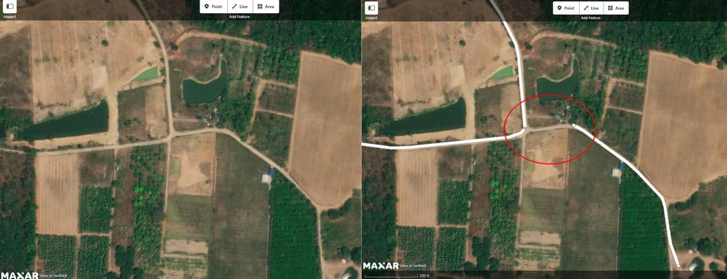
  1. 13.50442,99.62466 where residential road is unconnected. From the imagery, we can clearly see the same surface between existing road and missing road (red circle). I also check with many sources, And I think that we can add the road into this task.

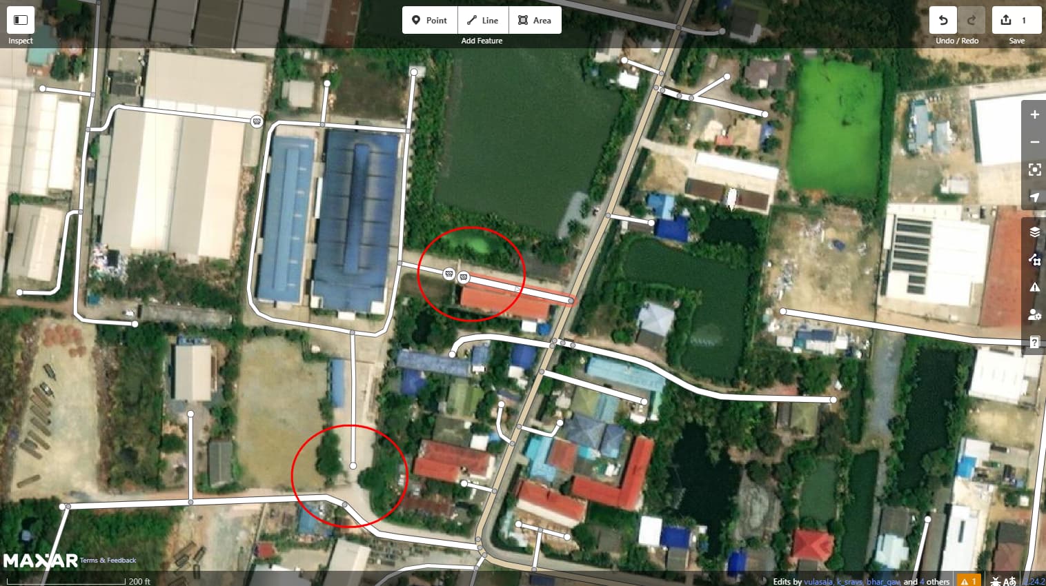
  1. 13.60626,100.33235, This task is interesting. From the imagery, the missing roads can be added, we can then see that it is private area. If you check it a bit more cautiously, there are fences at 13.605370, 100.331520 and 13.606341, 100.332022 as well, and to avoid not to update the roads and make routing like shortcut going through private area, I think this case after connecting the roads we need to add ‘access:private’ into roads in private area.

I have fixed 3-4 tasks so far and I think that I would skip some tasks with no source support at all, which will give us some proof points to analyze internally and improve our processes. Some tasks are editable and better to fix rather than eliminate the violations.

The project is not for remote mappers indeed, and our intension is for everyone, either Thai or foreigners with more local knowledge and footprint is welcome to edit, even we can discuss with GRAB and Bolt on support that will gain all of us benefits to fix those isolated roads.

Salim and myself will be available and welcoming any inquires and questions that you might still have , and we are always encouraged and motivated to have a constructive dialogue

สุพรรณ์ฉัตรจาก TomTom นะคะ
ขอออกความคิดเห็นเกี่ยวกับโปรเจ็คแก้ถนนลอย หรือ Isolated Road ในฐานะคนทำงานแผนที่มาหลายปีดังนี้นะคะ
ถนนลอย (ต่อจากนี้จะเรียก Isolated road) มีความเป็นไปได้สองอย่างคือเราลืม connect ให้มันหรือในความเป็นจริงถนนอันนี้ไม่มี หรือไม่เราก็อาจจะเราใส่ road class มันผิด ถ้ามันอยู่ตรงนั้นจริงๆ

ยกตัวอย่างความน่าจะเป็นสองอัน
แบบแรกเราเห็น trail ลอยๆอยู่กลางป่าใน OSM Map แต่ในความเป็นจริงคือ เรามีถนนเข้าไปยัง isolated trail เส้นนั้น แต่แค่ connection มัน missing อยู่ ฉะนั้นในเคสนี้วิธีแก้ก็คือ สร้าง missing road
แบบที่สอง มี isolated trail อยู่กลางป่าเหมือนเดิม แต่ในความเป็นจริงคือ ไม่มีทางที่รถสามารถเข้าไปได้เลย ต้องเดินเข้าไปเท่านั้น ถนนที่ลอยอยู่ควรเปลี่ยน class ไปเป็นทางเดิน (Foot Path) เพื่อความเหมาะสม เพราะในความเป็นจริงเราไม่สามารถขี่มอเตอร์ไซค์อยู่บนถนนคอนกรีตอยู่ดีๆแล้วกระโดดไปที่ตำแหน่ง isolated trail กลางป่าได้ทันที ยังไงก็จะถนนต้องมีทางไปเสมอ หรือไม่ก็เป็นซอยตัน

จะหยิบตัวอย่างของ task ใน project มาพูดถึงสองอันนะคะ

ตัวอย่างแรกที่ 13.50442,99.62466 ตรงที่วงสีแดงไว้คือต้องตัดสินใจว่าควรแก้หรือไม่ เคสนี้พอลองปิด road layerดูจะพบว่า ลักษณะพื้นที่ ของภาพถ่ายดาวเทียมบริเวณมีถนนกับไม่มีถนนไม่ต่างกันเลย และเป็นรูปแบบถนนชัดเจน เคสนี้เลยสร้างถนนตรงวงกลมสีแดงค่ะ

ตัวอย่างที่สอง 13.60626,100.33235 ถนนลอยๆอยู่ในพื้นที่ที่น่าจะเป็นพื้นที่ส่วนบุคคลแน่นอน ซูมดูใกล้ๆตรง 13.605370, 100.331520 และ 13.606341, 100.332022 มีประตู แต่ในความเป็นจริงเราก็ต้องขับรถผ่านถนน ผ่านเข้าประตูเข้าบ้านไปอยู่แล้ว ในกรณีนี้จึงพิจารณาใส่ access:private เพิ่มในถนนส่วนบุคคลให้ด้วย เพื่อที่ routing จะได้ไม่ route ผ่านพื้นที่ส่วนบุคคลของใคร

ระหว่างที่รีวิวงานก็ได้ทำ task ไป 3-4 task นะคะ และอาจจะข้าม task บางอันที่หา source ไม่เจอ และจะรวบรวม task ที่แก้ไม่ได้ ไปวิเคราะห์เพิ่มเติมหลังบ้านค่ะ โดยรวมโปรเจคนี้มี task ค่อนข้าง valid พอสมควร สามารถแก้ได้เลยดีกว่าทิ้งถนนลอยไว้ให้มี error ไว้รอ survey ค่ะ

ะเพิ่มเติมนะคะ โปรเจคนี้จริงๆแล้วไม่ใช่สำหรับ remote mappers ค่ะ ความตั้งใจของเราคือเราอยากให้ทุกคนไม่ว่าจะเป็นคนไทย ต่างชาติที่อาศัยในพื้นที่นั้นๆ มาร่วม edit ค่ะ ทาง Grab หรือ Bolt เราก็พร้อมคุยค่ะ คิดว่าทุกฝ่ายจะได้ประโยชน์ในการแก้ isolated road แน่นอน

ซาลิมกับดิฉันอยากให้ทุกคนเข้ามาร่วม edit กันนะคะ และพร้อมตอบทุกคำถามที่เกี่ยวกับโปรเจคนี้ ใครมีข้อสงสัยสามารถพิมพ์คำถามทิ้งไว้ได้เลยค่ะ

Cheers,

Supannachat

3 Likes

Indeed, access=private and noexit=yes are very important tags and are definitely lacking in Thailand. If you aware of the existence of gates/restrictions, please also include them.

However, my concern remains that it’s impossible to know using imagery alone that a road has access restrictions. In the example above, only Google Streetview could provide me with this information (no Kartaview/Mapillary available) and we are not supposed to use it.

FYI: I would not recommend combining both noexit=yes on both sides of the fence as you changed today since people also rely on renderers and most will not show anymore a separation. Having a gap allows to include a fence and more data. We have covered this in the forum before: Confirming unconnected highways - ประเทศไทย (Thailand) - OpenStreetMap Community Forum

2 Likes

i think it is a fair approach to try to fix the “easy” findings first.

Out of the three examples by @julcnx I just fixed the later two. Leaves the construction site where we won’t know how it will look like when completed, unless we get some more recent source.
Similar to the example by @SupanchatMetta
The first one was easy to fix, the second one is much harder without source.

If the process would allow the mapping team to skip such unclear cases, then I think with this challenge you could get rid of the majority of unconnected road islands.

Supannachat also brought up a valid point: Currently the routing is broken. Roads are unreachable.
So it won’t get worse from a routing perspective. That speaks in favor to doing a best guess.

What we loose when we are guessing: Currently we know easily that there is some unclear situation, because QA tools will flag it. If a connection is made and that guess is wrong, then routing would try to guide you through a wall, worst-case. We no longer have an indication that something was just guesswork.
It might help to add in such a case a fixme tag to that road segment to mark is for review on the ground.

I have not much hope that someone will actually work on the fixme tagged elements, but at least it would be clear that some review is advised.
I would only add such a fixme in cases where it is not obvious how the connection is made.

Missing access tags are here not enough to justify a fixme. And a lack of them will cause no harm. if there is a single access to the road network to resolve the isolated island, then there won’t be any via routing. Only routes to a destination. And if you have something as a destination, then very likely you also have permission to go there.

4 Likes

Thank you for your valuable feedbacks @julcnx and @stephankn,

I just updated ‘access:private’ and connecting geometries at Node: 6004008932 | OpenStreetMap and Way: 636724432 | OpenStreetMap. Now I got it, I did not make change of ‘noexit:yes’ I still would like your suggestions and guidelines for this topic and some other topics in OSM too :slight_smile: . We can discuss about this later.

Understood

Agree, we can skip some unclear situation like this in this challenge.

Regards,

Supannachat

2 Likes