Kindly excuse me for this late notice but apparently teams and outlook is not working from the location I am in at the moment, do you mind sending a zoom or google meet link for our call? would be appreciated if you can paste it here.
@sbaido
No problem. We still have roughly two hours left
I will set up some emergency fallback solution on my server. That’s then not fine-tuned, but should work.
Do I understand correctly, that your location blocks network access to teams? (As usually a simple browser works to start https://teams.microsoft.com/). What alternative meeting solutions are allowed for you? Any specific requirements in regards to network ports/protocols and such?
@jinalfoflia Would you have a corporate solution at hand? The free alternatives of zoom/skype/etc are frequently limited in participants/meeting time.
I have a BigBlueButton room available with max 8 participants. I check to get a Jitsi self-hosted up. That should give more participants. But at least some fall-back is ready. I will post final meeting links shortly before the call
Let’s start with the zoom one. I have meanwhile a Jitsi instance running. Quick tests indicate that it is working. To my understanding we would have no hard limitations in terms of participants or meeting time.
I can share on demand alternative link during the call before free zoom time expires
As we had in the beginning an interesting conversation about which tools to use mapping tasks: Salim, did I understand it right that you are still in contact with Martijn regarding Maproulette? Do you think it could be possible to enhance Maproulette so that it stays in proximity when doing tasks? So instead of wildly jumping, it would hop to the closest open task?
I personally found it useful when remote mapping to get familiar with an area first. So looking at different imagery sources, checking GPS tracks and such. Then I worked on multiple findings in an area. Like wrong tags, bad geometry/connection issues and similar. This resulted in a relatively small changeset and also often allowed to recognize that some mistakes had been systematic by a mapper in that area. This allowed to also fix other things.
This is a bit conflicting with your strategy of fixing one aspect after the other. What are your feelings about combining multiple tasks?
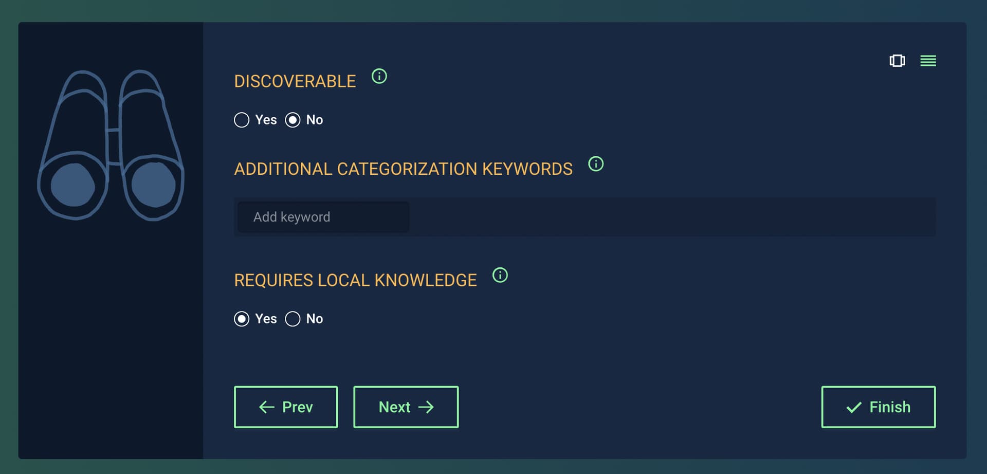
Under the Adjust discoverability settings of a challenge, there is an option to turn on REQUIRES LOCAL KNOWLEDGE however I am not sure yet if it’s actually using the mapper’s physical position.
“Tasks require local or on-the-ground knowledge to complete. Note: challenge will not appear in the Find Challenges list.”
Thank you for meeting up again and excuse my connection.
To answer your question shortly, yes, tomtom is contributing to the MapRoulette Roadmap in which Martijin will share soon.
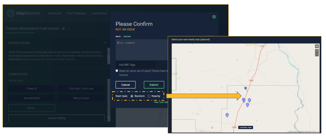
as of your question regarding tasks proximity, on the MapRoulette web version, users can select nearby tasks using the Multi-Task Work Widget. Documentation is available here: https://learn.maproulette.org/documentation/solving-multiple-tasks-together/. When closing a MapRoulette task, users also have the option to select the next Random tasks or a Nearby task on the challenge prior to submitting the status on the current task. The starred location shows the current tasks and the nearby tasks are displayed a pins.
already question is asked and will come back to you once receiving an answer, nevertheless, it will not harm to ask Martijn directly on the forum if you require more info on MapRoulette.
Hello folks, apologies for using this thread but seemed like this is the best place to communicate about this particular development.
My last day at Grab is soon approaching, I’m moving to the Netherlands to start a new adventure.
It has been a pleasure working with all of you and building this synergy where we are all trying to work together. I have learned a lot from my interactions with everyone. If you are in the Netherlands and want to have a mappy conversation, please hit me up
I’ll still be mapping on OpenStreetMap but just from a different location. Going forward @Saikat_Maiti will be the PIC from @Grab_Geo side to continue the ongoing engagement as well as for all future projects and campaigns. @Saikat_Maiti has been an avid mapper and comes with experience in OpenStreetMap and other geospatial technologies. Until next time!
All the best to @jinalfoflia from my side and thanks for the community support.
For another sync, I prefer a weekend, as this allows me better to fit it in my schedule. I am aware that this could cause you trouble to ask you to do actual “work” on a weekend.
Based on past experience it did not matter much whether we had a longer lead time or not. I’m proposing April 29. May weekends are quite busy planned already. If some other date fits the community better then this is also fine for me.