Lately, I have been running into quite a few roads that have been mapped many years ago as unpaved double tracks and that are now asphalt tertiary roads with ชม. XXXX signs.
It also contains missing tertiary references and I found the data to be very accurate in my area, it also matches some of my recent remote trips.
Since tertiary roads tend to be paved or will be prioritized to be paved, I want to avoid surveying those so I have started to look into adding missing tertiary roads where a reference might be available online.
Of course, it’s always better to check on the ground, but from my experience, it is often the case that existing tertiary roads have no signs at all, or signs may be even outdated (when there is a new bypass to avoid a residential area), or old milestones at starting points may not always reflect the latest OSM status.
Thanks! Looks great.
Are you aware of any search function where you could enter a road number and get more information like a PDF?
Tried a google search within drr.go.th but did not find anything.
The map you shared is still missing a lot of existing OSM tertiary roads including those with clear ชม.XXXX signage. Some are definitely recent so I assume the map might not have been updated. Others have been in OSM for many years.
Hm. The situation is not easy.
I prefer to collect road numbers on ground, and also to collect the milestones (though many of them are only partially written e.g. distance only, or not readable at all). Sometimes, the course of roads does not seem logical, and then the proof with milestones helps. So I prefer ground truth over DRR online data.
Except for a recently built road, the map on DRR’s website is unlikely to miss any of their own roads.
So, if the Rural Road is not found on the website, one of two things could happen:
In the case of a new road, the DRR’s website may not yet be up to date, so the sign on the ground can be trusted.
In the case of an old road that was built a long time ago, it is likely that the road has already been transferred to the local administrative organization, but the signage has not yet been updated. The local administrative organization should add the road to the Local Roads register and obtain the Local Road Reference (ชม.ถ xxxxx). By the way, not all local administrative organizations have completed that task.
The OSM tertiary road with no sign on the ground and nothing on the DRR’s website is undoubtedly a Local Road and can be referenced or not.
Thanks for the clarifications. So in case an old road ชม.XXXX has been transferred to the local administrative organization, and no Local Road references signs are visible, should the OSM road be kept as tertiary or downgraded to unclassified?
The wiki table is a little confusing, as it shows both Rural and Local roads should be tagged a highway=tertiary, while it seems Rural roads could also become highway=secondary ?
This is somewhat confusing due to the mess of Thai Authority’s classification. The transfer of the road from the DRR to the local administrative organization does not imply that the road has been degraded. It is simply a change in ownership. This is a little confusing, and I believe the importance of the Rural Road and the Local Road may be equal.
This is the problem with the DRR’s founding, which was originally intended to be an entity that would oversee a road for a period of time before handing it over to the local administrative organizations when things were ready. So, under ideal circumstances, the DRR should be abolished in the future.
Unfortunately, the DRR is growing and growing, and it’s occasionally building roads that are more important than 4-digit National Highways. This is the reason that the wiki does not assign a precise rank to their roads. It makes sense that most 4-digit National Highways should not be lower than secondary, while the Local Roads should not be higher than tertiary (except for some urban roads). But for Rural Roads, it can be a tertiary (in most cases), or higher (if their importance in road network is equal or higher than National Highways nearby).
So, to answer your question, the road should not be downgraded due to ownership transfer. And yes, Rural Roads could also be a secondary.
Hence: Should “สต. 1-0009” be used as reference number for the road now?
On the other hand, inconsistencies between road signs and milestones are not at all unusual.
I’m not sure if the transfer from the local administrative organization to the DRR ever happened. I believe it is possible, but it is a very rare case.
In your case, it is clear that the Rural Road สต.3005 has been transferred from the DRR to Krabi Provincial Administrative Organization. As a result, it received the reference สต.ถ 1-0009 (you miss ถ) instead. And of course, the former Rural Road ref should be replaced with the Local Road ref.
I checked Google Street View and found that the Local Road’s green sign is already there, at least in 2016.
Since the ownership transfer means that the reference number style will change too, the reference number style MUST NOT be used as a major criterion for highway classification.
I hope we could somewhen really reach agreement on that simple fact.
Not sure what you mean. Wiki currently says a tertiary Rural road ownership transfer to a Local Road will always stay a tertiary road.
A main trough traffic road without a reference will always be unclassified.
However, I do not like the fact major roads could be moved 1 level up based on their importance in the road network because this opens a can of worms where mappers will have their own interpretation and fight over it, but I am not so concerned about his because all motorway/trunk/primary/secondary should be already in place.
Down in Prachuap Khiri Khan, the main waterfront road is tagged as tertiary 3167, however, there are absolutely no signs/milestones on the ground, and both DRR registry and WorldTopoMap have no reference either. The only place where I could find the ref is Google maps & Tom Tom, and both have conflicting starting point.
Where would Google/TomTom get their info from? Are there any official sources other than DRR we could rely on to double-check a rural road reference?
The former National Highway 3167 has already been transferred from the DOH to a local administrative organization, according to https://th.wikipedia.org/wiki/รายการทางหลวงแผ่นดินในประเทศไทย/หมวด_3
Checked in the DOH’s database, http://hris.doh.go.th/ Not found. So that road is no longer theirs. If it is not in both the DRR and the DOH databases, it is 99.99% sure that it is now a local road.
Google Maps probably got it from an old National Highway map. I’ve noticed that many Google Maps ref aren’t up to date for this type of situation.
To delve deeper, the DRR’s local road registration database can provide some information. http://cld.drr.go.th/cld/main.html and the map page http://cld.drr.go.th/gisCldIntegration/index.php?all=true (The map layers is quite complicated.)
The register is not neatly done, so it can be confusing. The local road’s ref may not exist if it has not yet been properly registered.
Fortunately, that section of the former National Highway 3167 is well registered. Prachuap Khiri Khan Town Municipality now maintains it with a ref ปข.ถ 2-0002, 2.3 km length from point 11.817628, 99.798300 to 11.796578, 99.802464. It’s name is ถนนวีรกรรม, Wirakam Road. BTW, the municipality didn’t install the sign.
Another section of the former National Highway 3167 runs south to around Nong Hin Railway Station. Part of it is now in a military base, so no ref is provided. For the section south of the military base, since registration hasn’t been completed, I’m not sure who maintains it. But for sure it is now unreferenced.
Fantastic! can you please confirm that the cld.drr.go.th application contains references to roads that have been transferred to the local administration organizations, while gisportal.drr.go.th application refer to roads still managed directly under DOH/DRR ?
I have set up a small web page that shows all layers from both sites: http://www.cmoffroad.com/thailand-roads/
If my assumption is correct and the data is accurate enough, it should give a good indication of which major roads have been transferred or even downgraded in some cases.
In the case of the old 3167, it’s interesting to see the section going through Ao Manao military base was registered as a local road and as you said the southern section in Khlong Wan has not yet (or the data is simply missing).
Because some transferred roads have yet to be registered, the cld may not contain all roads. Checking to see if the road is in the DRR/DOH’s database may be easier.
Your page is nice. Noted that the gisportal.drr.go.th is reliable for only DRR’s roads (Rural Road). For DOH’s roads (National Highway), hris.doh.go.th is the best one. You can filter it by province to see all of their roads in that province. The location of the milestone is also shown.
For local roads, I can’t guarantee whether the map (http://cld.drr.go.th/gisCldIntegration/ ) is reliable, but AFAIK, the green line in the map is the best we have on the internet (though some registered local roads are still missing), while the gray road (L7018) is quite useless. (L7018 is a code for a map produced by the Royal Thai Survey Department, which is used by the Thai government. The gray road appears to be a road on that map.)
To find the reliable source for registered local roads, we have to go to the registration system. In the แบบ ทถ.6 tab of http://localroadregis.drr.go.th/lmp_rd_regis/waydata/roadregister/summarize_regist.html?cid=3558 , there is a list of all registered local roads with ref. However, some of them are missing the last digit, but we can guess from the order in the first column. (All local road ref will be 5-digits, regardless of where the hyphen is located.)
Things become more difficult because the แบบ ทถ.6 won’t tell you where the road is. You can either guess based on their name or go to http://localroadregis.drr.go.th/lmp_rd_regis/waydata/wayList.html?cid=3577 and find the same road. There would be a scanned registration document with a printed map attached.
Just wanted to share my recent experience regarding this topic:
A. The DOH/DRR registry database is not completely reliable. I’ve come across cases where the original tracing was altered, likely due to changes made during the planning phase. Unfortunately, some changes in Thailand are not properly documented. For example:
The end of 1396 now goes through 4WD farm tracks and includes a section that can only be accessed on foot.
ชม.7081 passes through a farm, including a footway section.
B. Local signage is also not always trustworthy. I’ve encountered situations where signs on the ground were intended for projects that were never completed. These roads are unpaved and have low significance for through-traffic.
Considering these issues, I suggest that we add a rule to the wiki stating that a sign or registry trace alone is not sufficient reason to upgrade an unpaved, non-significant, through-traffic road to unclassified or tertiary status.
Road section with mostly smoothness=bad shall be not higher than tertiary, and road section with mostly smoothness=very_bad or worse shall not be higher than unclassified, regardless of their official classification.
Do you think this is sufficient, or do you believe we need to establish further guidelines?
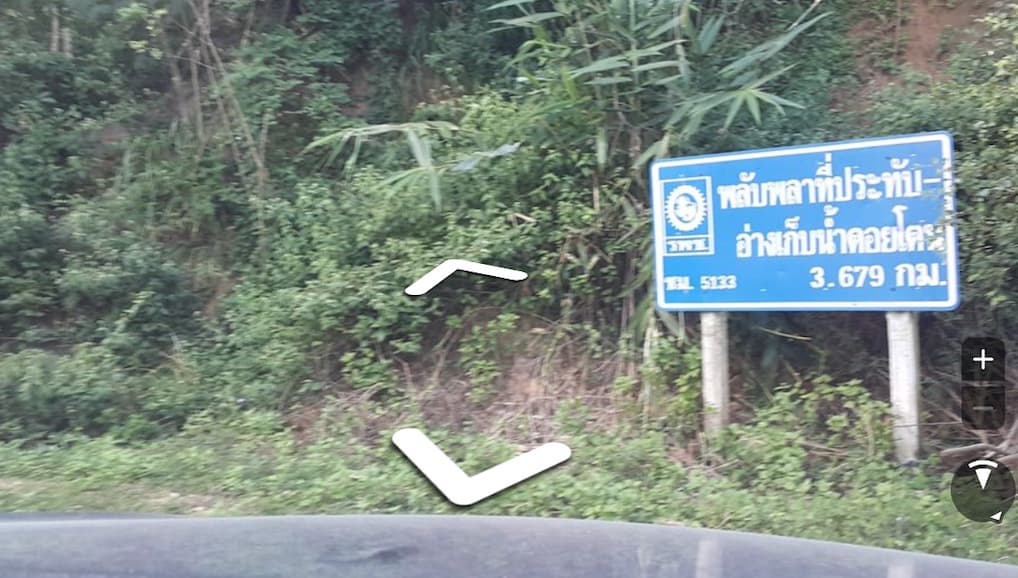
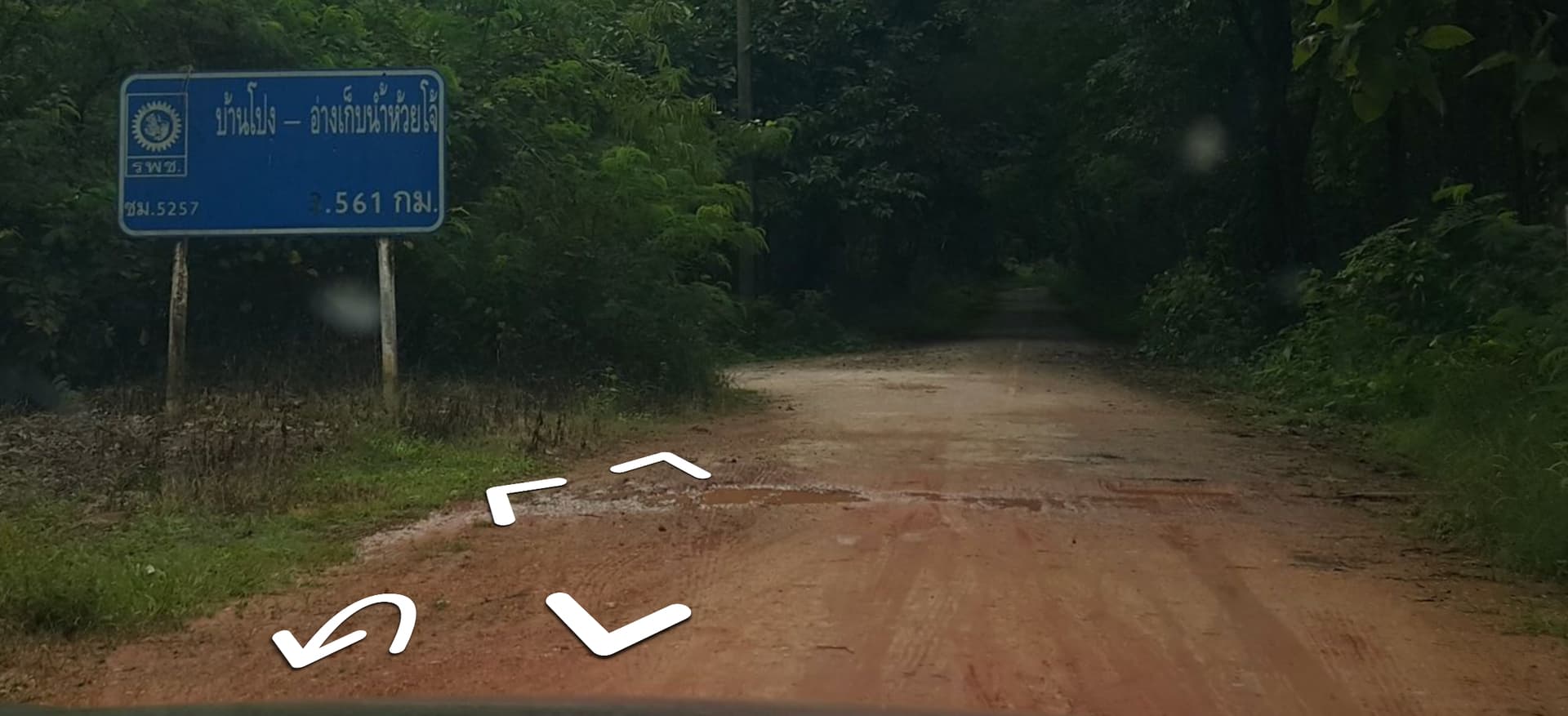
I agree that sometimes there is an error in DOH/DRR database. By the way, the sign in your images can leads to confusion. รพช.ชม.5133 and รพช.ชม.5257 are not “rural roads” that we classify them as a tertiary roads. It is an old sign from before the Department of Rural Roads was established. The รพช. has already been dissolved, and these roads have already transferred to various new owners. These ref are not to be used anymore.
Apart from รพช., there are ยธ. and อบจ., which their ref are also outdated.