Towpaths and greenways
Introduction
Out of ANYWAYS | Safe cycling to school we can see that the routing is avoiding an important section of the F20 fietssnelweg in favour of two roads, one on the other side of the canal and the other a few 100 m on the East. The latter supports a significant car traffic and busses. Something must have been wrong because the F20 is one of the best cycling infrastructure you could imagine.
After analysis, it became obvious that the tagging of the towpath as highway=service was the cause of the problem and that similar issues happen with many cycle routers.
2 solutions:
- Get all the cycle routers to change their calculation rules for a Belgian specificity
- Try to find out why jaagpaden are tagged as highway=service and find an alternative solution
This is the question I’m trying to answer in this document, starting from an analysis of the reality of towpath, then the relevant tags in OSM to finally propose a solution.
The current reality of towpaths
Jaagpad - Wikipedia (Dutch version) gives a pretty interesting description of towpaths. Towpaths are a remnant of the activity of towing boats in the 19th century. It has left an important continuous network of paths along canals and rivers throughout Europa and elsewhere. Today, their usage is much more diversified with parts specifically for service, others left as hiking paths, converted into roads and more and more into greenways optimised for bicycles (and pedestrians). Residential access is allowed if applicable.
Usually, there is one towpath on each side of canals, it tends to be much less continuous along rivers. In the Netherlands, there are only a few paths remaining that are recognisable as towpaths. In a lot of places, either there has never been any, or they have been replaced by regular roads or cycleways or simple paths. The same has happened in other countries, to a lesser extent.
Ownership and operation
Except in Wallonia, where the paths are managed by the ‘Directions territoriales des Routes et des Voies hydrauliques’, towpaths are usually owned by the national waterways authorities. This is potentially a source of conflict as their mission is not to enhance bicycle or pedestrian use.
The national waterways authorities make agreements with the regions/provinces for the refurbishment of towpaths for other usages, mainly cycling today. These agreements may or may not include transfer or operations responsibility and/or “ownership”.
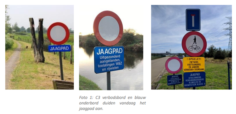
Unlike most other countries & Wallonia, Flanders use a specific sign to identify towpath jaagpad under C3 in Flanders, giving a hint that a specific ruling might apply. Germany does as well, but only to forbid access. FR, NL and Wallonia resort to standard panels from the road code. In Wallonia, the panel F99a (version without horse), valid for all greenways including towpaths and former railway tracks has the same requirements as the ones stated in the Belgian waterways code (30 km/h, access to residents & service). Note : By law, towpaths in Belgium are part of the road network and hence the road code applies. Only the Vlaamse Waterweg describes them as service roads.
Access
The access used often to be limited, not so much for reasons of service usage than because they were not designed with the safety and comfort of pedestrians and cyclists in view (poor surface, risk of drowning, narrow sections under bridges, interruptions around industries…) and because they sometimes remain closed for long periods because of works.
The result is that in a lot of places, bicycles and pedestrians use them “at their own risk” and explains the wide usage of combinations of signalling based on the white circle with red outer line (C3 in Belgium, B0 in France…), and a lot of confusion because of unclear combinations (see pictures below). The tendency today is rather to use blue square panels stated who is allowed access (F99x in Belgium, see picture below for France). It conveys a more positive message.
Greenways
Definition : Greenways are path specifically adapted for bicycle (and pedestrians), with specific signalling, directions and marked road crossings. They are usually tagged highway=bicycle + foot=designated if applicable. Fall in this category the fietssnelwegen, RAVels, voies vertes, radschnellwege etc…
Note : In most cases (BE, NL …), pedestrians are authorised on cycling infrastructure provided that there is no alternative.
Towpath in OpenStreetMap
Highway= tag*
As one can imagine, several different tags are used for towpaths in function of the circumstances:
- Highway=track : this implies that the width is sufficient for a motorised vehicle
- Highway=path
- Highway=cycleway à most frequent overall, at least when part of cycle routes
- Highway=residential, combined with destination tag. Very seldom because there are very few buildings/properties requiring access via towpaths
- Highway=unclassified, not very precise hence to be avoided
- Highway=footway, when applicable
- Highway=service,
- Flanders, about half of all towpaths, the remaining mostly tagged as cycleway
- France in presence of a C3 sign without exception, greenways tagged as cycleways + foot=designated
- Others : Only when specific access to locks, storage places / dead ends
! Very often, highway=service is generating penalties in the cycle route calculators. Example: on Grasshoper, the speed is 14 km/h on service roads against 18 km/h on most other types with asphalt surface. With Alltrails, an itinerary between Hal and Brussels intended to follow F20 generates 3 double crossings of the canal to take any kind of road on the other side etc…
Surface=*
This is a key indicator of the quality of the road and should be filled systematically in order to facilitate routing. Pls note that smoothness=* and grade=* (for tracks) are also used for the same purpose.
Towpath=*
Tag sometimes used to describe a towpath. Not frequent.
Vehicle= vs. motor_vehicule=**
Vehicle means any kind of vehicle, motor_vehicle is more precise. A bicycle is a vehicle…
Access and cycle routing
OSM tags for routing/Access restrictions - OpenStreetMap Wiki gives a comprehensive view of default accesses in function of the highway=* type.
It shows that most countries don’t propose provisions for usage of cycleways and footways by emergency services and maintenance. In fact, I’d be surprised if any countries would not allow these usages, provided that it is physically possible. Signage might be present or not and the legislation might be more or less strict of course. In Belgium, they are allowed and sometimes also indicated but not always.
Even though we should not map in function of the requirements of the renderers, it is essential that mapping is easily comprehensible by them so that they can take the right decisions and hence to use the same tags for similar things between countries.
Access restrictions for motor_vehicule use a variety of tags : no, private, permit, permissive, destination etc… The most frequent on towpaths is vehicle=no. For bicycle and footway, the most frequent is yes or designated.
For vehicles, the most relevant tag in Flanders could be vehicle=private as this corresponds to ‘only those with individual permission’ or motor_vehicle=destination whenever there is an access to a building/property in the section. Only problem, we have to choose between the two.
General recommendations from OSM
Duck tagging - OpenStreetMap Wiki : “If it looks like a duck, tag it as a duck (then refine if needed) à if it looks like a highway=cycleway, tag it as such”
Key:highway - OpenStreetMap Wiki : Note that “highway= distinguishes roads by* function and importance rather by their physical characteristic and legal classification. Usually these things are highly correlated, but OSM is not obligated to copy official road classifications”
Tag:highway=cycleway - OpenStreetMap Wiki & Tag:bicycle=designated - OpenStreetMap Wiki : Propose to the following combinations for greenways and assimilated :
- highway=cycleway (typically fietssnelwegen)
- highway=cycleway + foot=designated (preset in OSM as ‘Cycle and foot path’) typically RAVel)
- highway=path + bicycle=designated and/or foot=designated + surface=*
Note: there is some unclarity about when to use options 2 and 3 above.
Tag:highway=service - OpenStreetMap Wiki
“The highway=service tag denotes roads used for vehicle access to a building, service station, industrial estate, business park, beach, campsite, etc. It is also used for access to parking, driveways, and alleys. Service roads are not parts of the public road network, and may not always be accessible to the general public, which can be explicitly specified by an additional access= tag.*
Implicitly, they do not support through traffic, and access rights are expected to be linked to the access rights of the destination
Access key
- motor_vehicle=private for cases where only narrow group can drive vehicles (“residents only”, “with permission of owner only”, etc.)
- motor_vehicle=permit where anyone may drive there but needs permit that is in general given to anyone requesting it.
- motor_vehicle=destination : “uitgezonderd plaatselijk verkeer” / “Excepté circulation locale”
- Bicycle=designated : Use if signalled on street OR road specifically designed for bicycles
Note: There seems to be an open discussion about this.
Local references :
DE:Bicycle/Radverkehrsanlagen kartieren - OpenStreetMap Wiki : pretty detailed info
Waterways in the United Kingdom - OpenStreetMap Wiki. Towpaths to be mapped as footway or cycleway + towpath=yes
NL:Jaagpad - OpenStreetMap Wiki. Gives a good view on the relevant taggings for towpaths in Flanders today. The table ‘Type van highway’ is not in line with the global OSM documentation
WikiProject Belgium/Conventions/Cycleways - OpenStreetMap Wiki :
User:Eimai/Belgian Roads - OpenStreetMap Wiki
Conclusion and proposal
Tagging of highway=* must be as close as possible to what it looks like for most people, and in most cases, that would be path, track or cycleway.
The tag highway=service for towpath is not predominant and hence is to be avoided because of the implicit expectation that it is private and does not allow trough traffic. Neither of these affirmations is true in most cases. Anyway, the access for service/police can be considered as implicit on any kind of highway.
Renderers and bicycle route calculators tend to downgrade service roads against others.
The Vlaamse Waterweg is calling them ‘service roads’ because they want to emphasize their property and the access limitations on the towpaths. These claims can better be described by using the following tags or some variants of them:
- Motor_vehicle=private or even motor_vehicle=no if F99a
- Horse=no
- Foot=designated if mentioned (F99a for instance)
- Bicycle=designated if mentioned (D7, F99a…) OR if refurbished with asphalt, protected crossings, cycle route signalling etc… (RAVel/fietssnelwegen). Not necessary if highway=cycleway
- Speed_pedelec=yes/no
- Max_speed=30
- Identification (only when there is a ‘jaagpad’ sign) :
- Towpath=yes
- Owner=VlaamseWaterweg
- (Operator=VlaamseWaterweg)
Motor_vehicle=private
I know there is an open discussion about this. Acc. To the OSM documentation, this seems the most appropriate solution, knowing that it implicitly allows traffic with specific authorisation of the owner + residents (see above). Obviously a road allowing no traffic at all makes no sense…
Highway=cycleway vs highway=path+bicycle=designated
Depending on the source, greenways (RAVels, voies vertes…), open to both bicycles and pedestrians are marked as highway=cycleway or highway=path+bicycle=designated.
Even though formally the second option should be more logical, the consensus seems to be for the first option. I tend to agree with that provided that the design is effectively optimised for bicycles (profile, curves, crossings, length, signalling…) and bicycles are the most frequent on these paths.
OSM Wiki
If you agree, we could align the different wiki documentations around this line and combine the three Belgian pages referenced above (jaagpad, cycleways & EMAI)
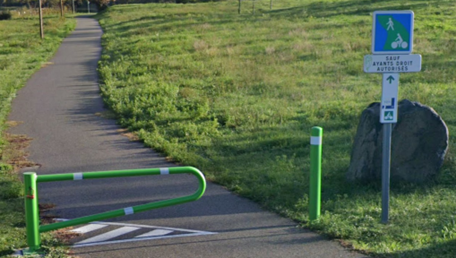
A few examples
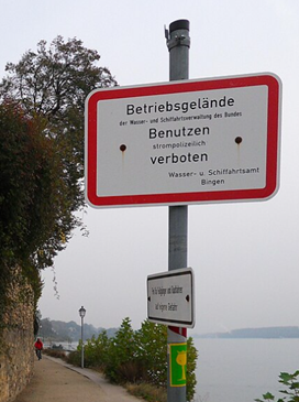
Can you tell what the right picture means ?  . Source : Beleidsvisie Vlaamse Waterweg. It seems that they are thinking about a solution to improve this. I hope with F99x signs or D7/D9.
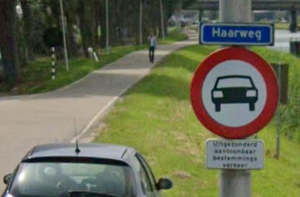
Haarweg, Arkel, NL. Mapped as highway=undefined + motor_vehicle = destination on one side highway=cycleway on the other.
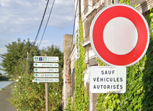
Don, France : Access forbidden, except authorised vehicles, just before cycle directions (EuroVelo 5) !
mapped as highway=service + bicycle=designated & footway=designated.
Mapping is result of an incoherence in the signalling.
Chateauneuf du Rhône, F. mapped as highway=cycleway + footway=designated
Eltville, DE : Access forbidden + bicycle & pedestrians at own risks. Mapped as highway=path + bicycle=no