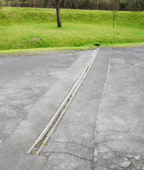
In rural areas in Germany one will sometimes see such steel gutters embedded in the asphalt surface of tracks with a steep incline, made to collect rainwater running down the track and direct it into the ditch on one side of the track.
There is no established tag for these objects which are very similar to rain gutters attached to roofs, being some 10cm wide and deep as well. The only thing I could find was some short discussion on the talk:key:inlet page ending without result.
My intention is to map it as
inlet=gutter
gutter=open
material=steel
width=0.1
and connect it directly to the ditch on the opposite site of the track. Any better idea?
That page does say that inlet= is only supposed to be used as a node.
Maybe Tag:waterway=drain - OpenStreetMap Wiki + intermittent=yes across the driveway & connecting to the ditch you mentioned? (Although, no, it’s not really a “waterway” but that’s OSM-speak for you!)
I would not see a problem here. If the linear gutter shown in the pic is to be understood as an inlet (which it is to my understanding) it would be easy to add this to the wiki.
+1 and moreover to my understanding the smallest element in a drainage network is the “ditch”. Having a “drain” of 5 meters lenght discharging into the roadside ditch would be like a “river” discharging into a “stream” imho.
Yep, man_made could be a solution, whereas in this case I would still prefer man_made=gutter which is already an established tag (1 x in use) .
Nevertheless I would prefer to stick to the established keys for stormwater drainage which are “inlet” and “waterway”. As the purpose of the gutter is to collect rainwater trickling down the track and discharge it into the drainage networt (a ditch beside the road discharging into a creek some 100 meters ahead) I do understand it as an “inlet” despite of the linear shape.
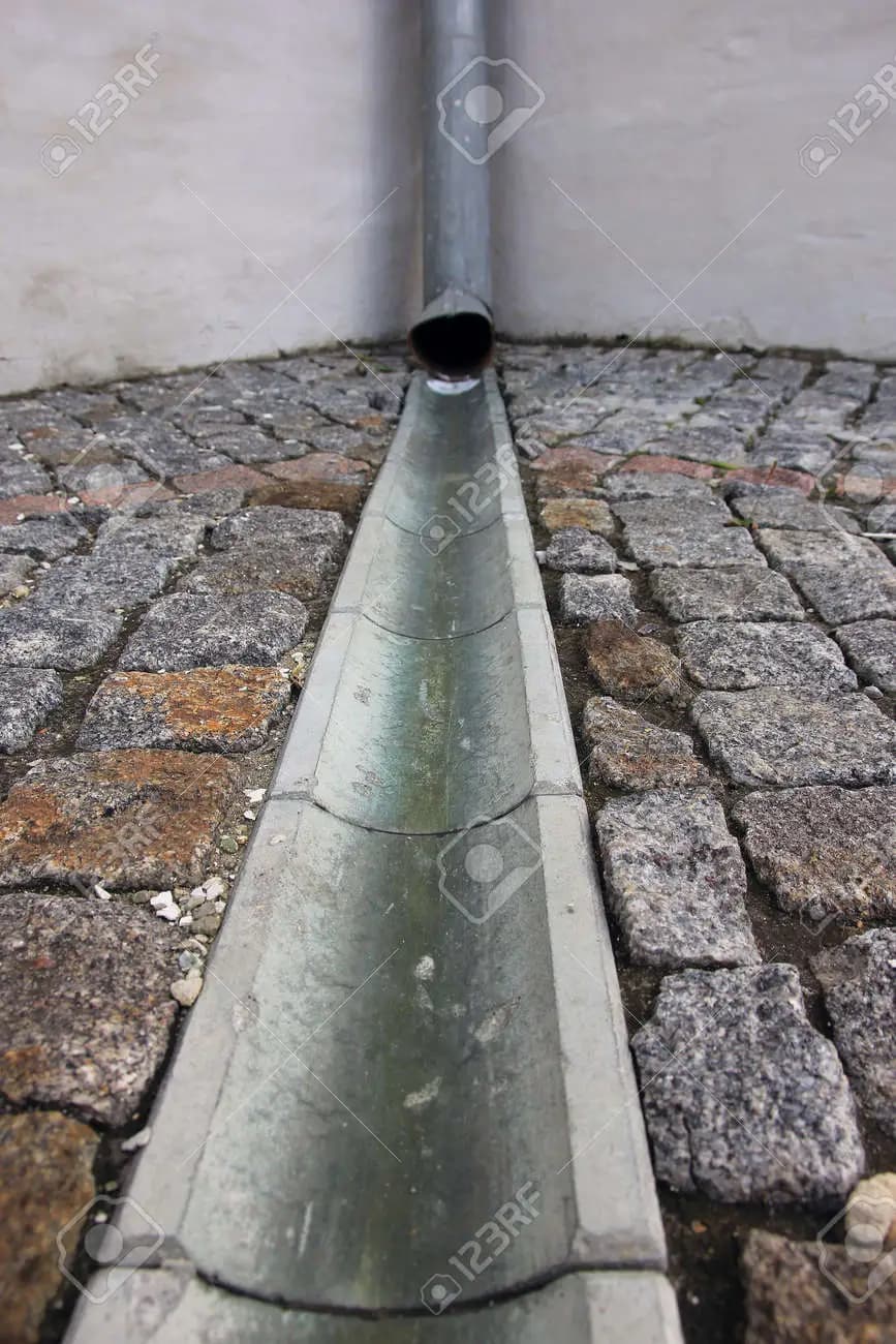
Again there are similar gutters in between private properties and public roads in residential areas built on sloping surface, acting as inlet for rainwater trickling down the driveway and discharging it into the sewage network. These gutters are prefab elements made of plastic, steel or concrete and covered with some grate usually and their purpose is clearly to act as inlets. You will find samples by a search for “driveway gutter” oder “channel drainage”.
We have lots of these in my area here which I am not mapping actually but who knows what will be in future? It would be helpful to define a tag covering all kinds of these linear inlets, like:
while this is also my understanding, it should be noted that there is no agreement and some people sustain that it only depends on the construction: just a ditch without hard borders: ditch, any artificial waterway used to carry away water (drainage) with concrete/steel/walled sides: drain.
The current distinction in the wiki is that a canal should carry “useful water”, including navigation, it also is used regardless of size (definition is: “An artificial open flow waterway used to carry useful water for transportation, waterpower, or irrigation”)
The canal page also says that drain and ditch should be used for small artificial waterways used for drainage (isn’t ditch also usable for irrigation?), but fails to state what should be used for not-small artificial waterways that do not carry “useful” water.
I think I’d use drainage_gutter to be perfectly clear, but am not entirely clear what use-case you associate with this. These might represent impediments on the path surface for people with limited mobility, or general impediment to pedestrian if blocked (e.g., by leaves) and flooding. In these cases a node might be more valuable, than the way which I presume you envisage. Other remarks:
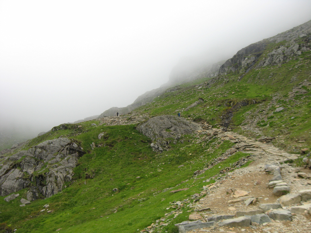
These are common and made of stone on heavily used mountain paths where footfall exposes a surface prone to runoff erosion (bottom right in image):
Linear gutters are quite common on share-use paths separating bicycle and foot traffic (example). If these are open and recessed they do represent a trip hazard.
I have always presumed inlets and outlets refer to nodes rather than minor flow channels, and I think extending to ways is not a good practice.
It may be worth discussing more generally in terms of SuDS (Sustainable (Urban) Drainage Systems) which include a range of small scale drainage structures. For instance, I mapped part of one very tentatively about three years ago (all tags provisional, particularly the dam ways).
“drainage_gutter” also sounds good to me, and yes, “channel(_drainage)” could be mixed up with “canal” which is another existing value for waterways, as pointed out by @dieterdreist.
The main reason to map this is because it is a verifyable and easy to identify object. Additinally it is definitely an impediment and a serious hazard for small-wheeled vehicles like roller skates or scooters (human powered as well as electrified).
Yes again, it is not an inlet as defined by the wiki (point where fluid enters a pipe …) because the rainwater collected by this steel gutter does not enter a pipe but an open ditch. In fact it is comparable to the linear gutter separating footway and cycleway in your sample. As both gutters are too small to represent a “drain” in my understanding a possible tagging could be
waterway=drainage_gutter
which would be a reasonable completion of the existing waterway tags. As mapping becomes more and more detailed it would well make sense to also allow more details in tagging imho.
The same tag could be useful for the driveway gutters mentioned in my last post. The problem with those is that in most cases they discharge the collected rainwater directly into the sewage network (pipes) and as such they are “inlets” according to the wiki definition qouted above.
I don’t think it would be good practise if the same object - a small prefabricated channel drainage covered with a steel grate - would be tagged as
If I’m analysing a “natural” water network I want to see that flows are logical (all in the same direction, and if an elevation model is available, downhill), and that there aren’t isolated ‘islands’ not connected to anything. The latter is an issue in terrain where rivers don’t flow into the sea: karst landscapes where they disappear into swallowholes, endorheic basins such as the Jordan and Dead Sea.
OSM Inspector marks start & end nodes, but doesn’t seem to use them for specific validation processes. However I could imagine that you could validate based on inflows should be a start node and an outflow an end node. Current actual usage probably makes this a non-starter because there are so many likely exceptions (including this one).
I don’t know if I understand what you want to express, sorry for that. Let’s say you have a small creek trickling out of the ground in some kind of gully in the forest. This is your start node for a waterway=stream (which could be tagged as natural=spring) . After some distance the creek enters a culvert and you don’t know where the culvert leads to. This is the end node of the waterway which you normally tag as inlet=* (direct/grate or whatsoever) and that’s it.
At another place the culvert is discharging the creek into open grassland. This is another start node which you normally tag as outlet=*. And so on …
If there is a driveway gutter collecting water which is trickling down the driveway and discharging it into the sewage system the idea was to tag the gutter as waterway=drainage_gutter and the point where it enters into the sewage pipe would be the end node of this waterway, getting the tag inlet=*. As far as I can see this would fit the waterway tagging scheme well. I can’t see the problem here.
I’ve seen very similar ones in Estonia, connecting roof downspouts to the roads drainage system, crossing the sidewalks using gutters like that. So, I guess “inlet” is only specific to the ones in the first post?
The last proposal was to tag these kind of gutters as waterway=drainage_gutter and add a node inlet=* where the water enters the underground sewage/drainage system.