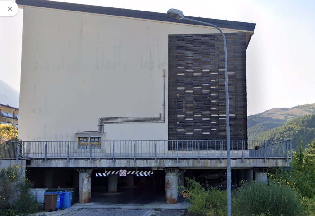
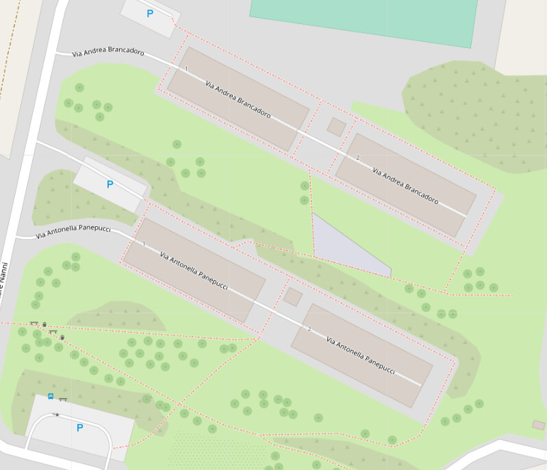
This and similar always seems to be a bone of contention, a picture ripped from Google maps. The maxheight sign is 2.05 hanging of height restrictor kind of flaps, parking with other pictures showing a caravan parked in there so 2.05 is relative. The parking way is through underneath 3 level apartment blocks, as there’s an open air section and then a second block of same with parking underneath. The footways around the buildings are level ground front and sides balconies, back level ground as build against a slope.
So are we dealing with
Building passage or tunnel
Level=-1 or layer=-1 for the ways?
Parking underground and/or covered?
Both the ways have each a different street name sign … residential or service? The blocks on each set of two have house numbers 1 and 2.
From this angle it almost looks like the whole thing is building:min_level=1, but I think parking levels do count as levels rather than something that isn’t a part of the building. The sloping ground complicates things a bit as I think it makes something that looks like a 3 storey building from uphill into a 4 storey from below and that’s what we’ve standardised on according to the wiki.
I think that probably makes these:
Overall (probably on a single way multipolygon (don’t hit me)):
– building:levels=4
– building=apartments
for the upper/inner inner portions:
– building:part=apartments +
– building:levels=4 +
– building:min_level=1
for the lower portion:
– building:part=parking +
– building:levels=1.
parking aisle through with
– indoor=yes and/or covered=yes.
If you do it this way though I’d say map the pedestrian area on top as a multipolygon with a suitable layer to be able to show it as accessible.
These are often described as undercrofts (although that term also is used for aspects of various medieval buildings too). I’ve been puzzling a bit about them too (there’s a substantial one for staff parking in the local hospital, and new student flats seem to have been built with them too - although I think the main reason is that they are in a flood zone). I also used to work in a modern building with one.
I suspect that whether to treat them as basement levels or above ground levels will depend on the building. The student flats and hospital both have level access from roads to the level above, so I would treat them as basement levels, but the other building had steps up to the main entrance and there it might possibly be an above ground level (although I’ve just added level=3, feel free to change) Bing imagery provides a useful view of the building.
This latter building also has a feature I’ve been uncertain how to map, a brise soleil which can be seen in the Bing imagery. The building is largely glass, but the council objected, so rather than change the building design they added free-standing brick-faced walls (perhaps connected to the building for safety) with apertures corresponding to windows in the actual building.
Thanks for that ‘undercroft’, knew the word in different context
" undercroft. / (ˈʌndəˌkrɒft) / noun. an underground chamber, such as a church crypt, often with a vaulted ceiling ."
Now know we have quite a few apartment buildings in town constructed like that but on level ground only central entrance area to stairs and elevator. People park their cars below in summer time, put otherwise just on the street_side parkings. Navigating those columns always risks damaging the holy bovine on 4 wheels :O))
PS Taginfo has a few under the name tag and as note since today " note=parking␣aisle␣in␣undercroft␣parking␣area" but otherwise oblivious.
Please keep puzzling and share the advances in insight of what is your solution.