Just a quick update on the topic and a big thank you for all the valuable inputs!
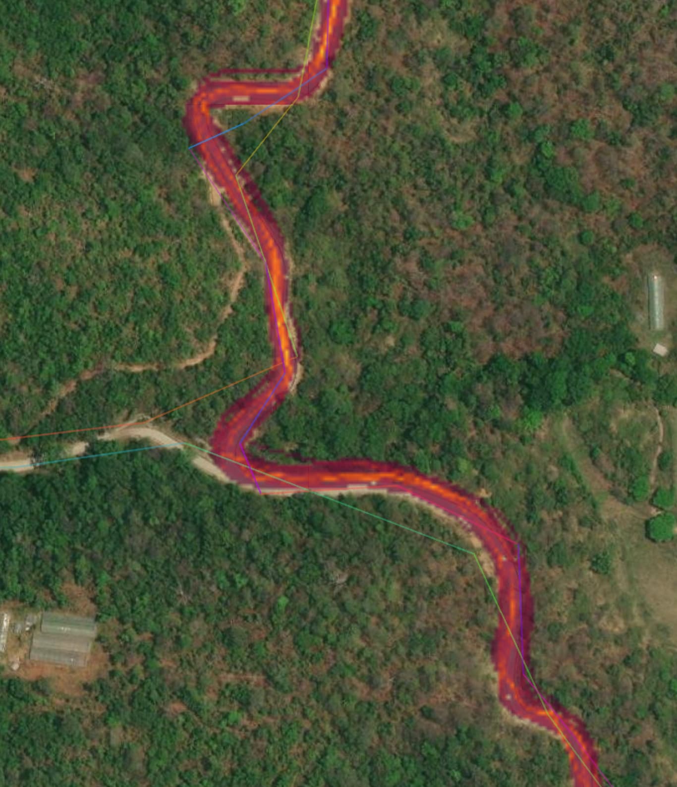
Since our last discussion, I have implemented some of your suggestions. For example, I now specify the source:geometry=strava when realigning paths using the Strava Heatmap, especially in areas where GPS traces are limited.
I’ve also noticed an interesting use-case in my area where Strava users actively contribute to finding missing trail connections. When I add trail segments based on older imagery like Bing or ESRI Clarity, I often see Strava Heatmap lines appearing a month or two later, connecting the added segments. This motivates me to extend the OSM data and consider further tagging after conducting a ground survey.
I’ve been using @ezekielf’s JOSM Strava Heatmap browser extension for a while, and it has been an invaluable tool. However, iD lacks a custom Overlay URL mechanism, limiting the visibility of the heatmap to a background layer only.
Considering the complexity of the current URL mechanism and limitations in iD, and after consulting with @ezekielf, I’ve decided to take up the challenge and develop a separate Chrome extension that focuses on iD and simplifies the process:
Thanks for doing that. Strava users (at least those near me in the UK) don’t always follow signposted paths and regularly hop over gates and walls. Personally, I’d never add data from Strava with no other information (e.g. survey) to back it up, but their heatmap is nevertheless useful to “average out” more GPS traces than there are just in OSM.
Recently a mapper did just that close by on the base of strava. If he had looked at the aerial, or had been there on location: There really is a zigzag just as was mapped, not nearly straight, as strava averaged out. Nevertheless, strava is quite current and I trust it a lot more than my single GPS tracks, e.g. where trails got moved and aerial/lidar out of date.
What gave you the impression that Strava traces are “averaged out”?
From my understanding, Strava heatmap are based on a combination of numerous GPS tracks from devices with high accuracy. The overlapping pixels between different traces are represented with a higher color density. The same technique could be applied to OSM traces overlay with more data.
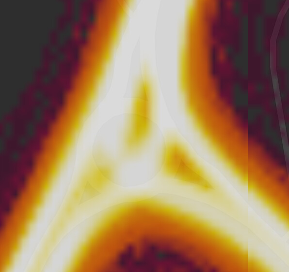
In my experience, I have not come across any instances of “averaged out” Strava lines cutting through hairpins, unless there is an actual shortcut (often a foot path) or the number of Strava traces are too low (a few lines without intersecting “heat”).
I regularly conduct ground surveys in remote, forest-covered areas and can attest to the high precision and accuracy of Strava’s heatmap.
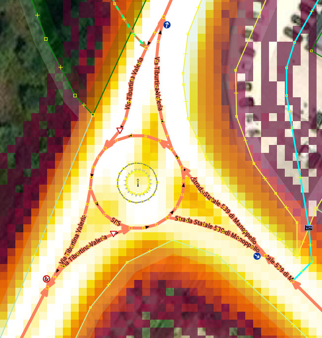
This is of supreme interest since roundabouts pop up all over the place without having aerial, at least 4 more in are being build. When found opened I cycle multiple times around the inner and outer edge and use the GPX trace to map it later but great it aint,
That said, went to a recent ‘cycle traced’ location where having added a roundabout and got this where the old junction traces are clearly visible. Surprisingly the few cycle traces used to map the new junction construct fits nicely, vaguely showing through from the OSM map underneath.
PS This is a many centuries old route, the road managers finally learned that ‘upcoming’ roundabout signs have to be placed few hundred meters before as those doing this way day in day out will inadvertently park their car on the central traffic island… pictures in my cloud.
As an example, imagine that I record a GPS trace across some moorland. It’s going to be offset a couple of meters either way, as it’s just taken with a consumer GPS. However, if lots of other people have recorded traces here, it’s useful to look at those - and that’s what the Strava Heatmap shows. The information from those, and from imagery (which in moorland areas near me can easily be offset a few meters too) can be taken together to create a best guess of where the path actually goes.
That’s how I understand a heatmap to be, it’s helps to very closely determine where an professional GPS would trace the way. The more pass a point with their Android or Garmin the better the mean. Zoom in but not too close when drawing lines.
Found some lines I would not dream of using to map farm tracks, but located high concentrations where mountain hikers / MTB riders pass and mapped a few forest cutline=piste which superbly follow the sat imagery of ESRI where countless skiers have downhilled. Saved the Strava layer in JOSM as a top link for ad hoc activation when the need is there to map new or verify old.
I’m still a proponent of putting the source on the changeset, not on the ways themselves.
If someone else (probably a less experienced mapper) realigns these ways in the future, it is very likely that they will not touch your source:geometry-tag, even though it will no longer be correct.
See also the wikipage for the source-tag.
I’ve tried this approach before, and unfortunately, it doesn’t work. Most mappers don’t take the time to review the full history and associated sources for each change. From my experience, using extra tags like source:* or note:* is the only way to effectively inform and prevent unwanted changes.
Furthermore, the additional tags can be queried in Overpass for further analysis, which is not feasible with changeset metadata such as the source or description fields.
is not my experience. Too often have I realigned buildings and ways, that have been realigned multiple times by other users before and that have had a source:geometry=whatever for the last 10 years.
What is this analysis worth, if possibly a large part of the source:geometry=* is no longer correct at all?
I regularly conduct ground surveys in remote, forest-covered areas and can attest to the high precision and accuracy of Strava’s heatmap.
their heatmap has a given resolution an all details finer than the resolution cannot be captured, naturally. Precision and detail is always relative. I agree that strava has sufficient resolution for typical OpenStreetMap use, but it is also true that it doesn’t show small details like zig zagging within few meters
Most mappers don’t take the time to review the full history and associated sources for each change. From my experience, using extra tags like source:* or note:* is the only way to effectively inform and prevent unwanted changes.
I have not experienced less people performing unwanted changes if specific tags like note or source have been present, these are, from my experience, just ignored the same as changeset tags. It is also not clear what you should do if the source for something is X - if you believe it’s wrong, outdated or imprecise you will typically try to improve it regardless of the claimed source.
I try to convey in changeset comments whether I have been to a place or not, and if not, whether I am generally familiar with the area/region or doing blatant remote tracing with no immediate ground truth whatsoever. If I had high precision equipment or third party sources at disposition, I would also add a hint about this, but I don’t usually, nor does the vast majority of fellow mappers.
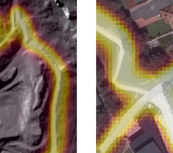
Not only does Strava average out small details (zig zag in picture below right over aerial - no shortcuts to be seen, neither on the ground) - it also suffers from GPS shortcomings on the sides of steep hills (shift in picture below left over lidar, terrain not walkable beside way).
This is just how I use Strava, but it’s good find new trails sometimes. I don’t use it for doing 1/1 mapping though because of the issues Hungerburg has brought up. Although I’m sure you could use it for directly mapping trails in places that are flat, unhilly terrain perfectly fine. Especially if your doing it in conjunction with the satellite overly (or is it an underlay at that point? ). It’s great to use if you want to find new paths in wilderness areas to map though. Just don’t use it on it’s own or without double checking the satellite images before mapping the paths.
Let’s shift our focus to new topics since we have moved away from the original legal thread, which I believe has already been addressed.
I haven’t had the opportunity to experience this yet since our community is very small. However, I will take into account the suggestion of including the source in the changeset metadata instead.
One aspect that particularly interests me about these additional source tags is the potential to visually distinguish between GPS-based geometries and imagery-based geometries. This differentiation is vital for ground survey mapping in remote regions:
As you pointed out, these are general GPS accuracy limitations. I am confident that if the OSM GPS traces overlay were displayed for these locations, we would likely observe similar patterns.
Let’s continue this conversation in the following topic: