Hello, I’m new to OSM and just getting to grips with everything.
I just wanted ask about stop/give way signs, and if there is any value in adding them to a map, ie. does the data get used or ingested anywhere helpful?
Thanks.
Hello, I’m new to OSM and just getting to grips with everything.
I just wanted ask about stop/give way signs, and if there is any value in adding them to a map, ie. does the data get used or ingested anywhere helpful?
Thanks.
In theory routing engines can use them to adjust the expected delay at an intersection, but I’m not sure if any actually do.
I think OSMAND will warn you if you are approaching a stop sign (so that you can slow down).
Ask cyclist and yes if they can be avoided it makes sense.
Cheerio John
Routing engines do and those who dont should use that for calculating a delay. As they typically have a delay for right and left turns (different) based on the country you are in (right hand vs left hand driving)
Flo
Actually mapping them as nodes on the road instead of signs on the side as I did in the past and add the road_marking tag on top to indicate no, solid_stop_line, stop, give_way. solid_stop line per TagInfo has already found 34K uses
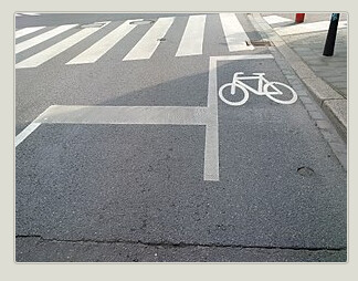
Here IT:II.36 or 37 for signs and stop or give_way for road markings which are nicely graphically shown on JOSM in edit view with a little beam/cone style to show which way they’re pointing
Magic Earth even shows stop and yield signs in their app.
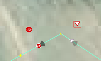
Is that a custom paint style showing the cones? I haven’t seen those in JOSM before.
Yes, a real small one just with the cones for stop, yield and traffic_signals (one directional only, not both or 4 ways on a crossing. Style name: orientation for traffic signs… https://gitlab.com/cartocite/josm-style-traffic-signs-orientation/-/raw/main/traffic_sign_orientation_style.zip. Introduced here somewhere on the forums.
There are three different things to distinguish:
highway=stop on a node along the roadway where the vehicle must come to a stop.traffic_sign=stop or a locally relevant sign code on a separate node at the location of the stop sign, but some mappers combine it with the stopping point.road_marking=stop_line or solid_stop_line way running the length of the marking.All three features are mappable; none is mutually exclusive of the others. There are many situations where all three could be located at different positions in the real world. For example, most stop signs where I map are placed after the marked crosswalk, even though state law requires you to stop before the crosswalk. Stop line markings are often combined with crosswalk markings.
I’m unsure about the rules when the crossing is unmarked. I place the stopping position before the crossing if the stop sign is pretty close to it, but not if the crossing is set farther back:
Not much if any software supports road markings yet, but I find them helpful for justifying where I place the stopping position, since there can only be one along the way but there may be multiple crooked stopping positions in reality.
OSMand warns if you are approaching a highway=stop, which is the line rather than the sign.
Unfortunately it doesn’t warn when you are approaching highway=give_way which are much more common.
Yes. I extract alerts (speedcams) from OSM regularly - ex. traffic calming, speed camera, stop, give way, traffic signal camera, maxheight, etc.) for use in GPS navigators such as iGO, 7Ways, Garmin, etc.).
The trouble I have with this is stop lines drawn the full width of the road on a non-oneway as I saw one. How would routers know for which direction that stop line applies? I’d expect the line on a bi-directional only to be drawn from the road just stretching along the lanes painted on. The offending example to me on Sonny Kim, 3 lanes, 1 forward, 2 backward.
I don’t think this tagging scheme is capable of being used by routers. It’s better suited to renderers that provide lane-level detail. For routers, we would need something similar to the rejected wait:lanes proposal that pertains to the stop position. After all, a stop or yield position can exist without a marking of any kind. In the U.S., a yield position is the norm for a left turn lane along a road that has the right of way (priority) at an intersection. No one maps these positions because they don’t want them confused with full-width yield lines.
At one point, after an autonomous car company bulk-imported stop lines in my city overnight, I insisted that they connect each way to the roadway for routing purposes. They did connect some of them, but later I became less sure that they should be connected, because it makes
direction too ambiguous if the stop line happens to coincide with the stop position (which it usually does).
They did start rendering a few road details recently, bumps, stop signs, etc.
I hope they actually take them into account when routing
Does a sign make a difference to routing over the line?
In my experience there is never a sign without a line. Stop signs are rare here, they are only used where visibility is restricted by something like a building and you will often need to stop and lean forward to see. Give ways are much more common and on minor roads there are only give way lines with no sign.
Here in Alberta where we have a lot of snow, stop signs are the norm as the white line is covered by snow and ice 4 months of the year, and the lines get scraped off by the snow ploughs.
It varies regionally. In the U.S., stop signs are the norm by a long stretch. (Some towns here and there never got on the bandwagon and still have uncontrolled junctions in residential areas, and I’ve been to a few towns that post yield signs all over.) Marked stop lines are usually used along high-traffic or high-speed streets, where the stopping position is ambiguous, or where there’s extra concern about protecting pedestrians. Otherwise, unmarked stops are extremely common in residential areas. On the other hand, stop lines without stop signs are rare and non-compliant.
The US is a bit special because just about every crossing that doesn’t have traffic lights has has stop signs, but nobody is expected to actually stop, people just treat it as a yield sign. I still think that we should probably map them as they are theoretically instead of practically, same as we treat the speed limits that nobody cares about in the US.
It isn’t theoretical when a cop happens to pull up to the same intersection. ![]()


