They do. Because it is resource-heavy (although they do have other reasons too).
Now imagine it being (at least!) thousands of times more heavy, and 24/7/365 instead of just few days after update. That is what would happen if every editor went to use overpass instead of TMS. That is no-go, really.
Yes, you would simple do difference of the sets (i.e. (.addresses; - .result;); instead of just (.result;);), like this: overpass turbo
I’m not a big user of iD, but AFAIK, it does have Custom background option, where you can copy/paste any TMS URL (like those you see in JOSM). Perhaps not as user-friendly as a simple click, but should be somewhat workable.
While they are nice and useful to detect areas without addresses, they AFAICT miss the primary thing that Steve was proposing, and that is staleness (i.e. anything that was not updated in xx years should be considered stale and in need of updating).
I don’t really want to side track the discussion with a tangential conversation, but I don’t want people thinking I’m just making up things just to be inflammatory or whatever either. So at least according to the top comment on this by someone who is on the Discourse team “Flags from some well trusted users might perform automatic actions like hiding.” There’s also multiple comments in this discussion from October of last year where multiple people (including moderators) saying a user can hide a post simply by marking it as off-topic.
So unless the settings have changed since October, yes posts can be hidden just by flagging them. At least if it’s done by someone with a high enough trust level or for that matter multiple people, but neither one of those scenarios make what I said false. Although again, that’s contingent on the settings not being changed since the end of last year, but there’s nothing to indicate in the conversation that I linked to indicating they have been.
Yes, I seem to recall this discussion too: "Post hidden by community flags". I don’t know what is the current setting of that feature, though.
(As a side note, I also didn’t find neither Simon’s comments about Steve’s lower accomplishments during his reign, nor Adamant1’s comment about Simon and other Europeans coming from places of privilege, as something intended to be insulting or breach of etiquette, but instead informative and relevant to the discussion. But I do acknowledge I might have thicker skin than many so am perhaps not ideal spherical user, and I’m not privy to moderator-only information in that specific case anyway).
If this occurs, I am convinced it is exceedingly rare. In the times I have observed hidden posts they (on non-community channels) were flagged by the forum governance team, the general moderators, or automatically hidden by the website because they were identified as possibly written by an AI. If people want to continue discussion on how posts are hidden, this can be continued in a separate thread in the general category.
The iD will not autofill the overlay layer. So, the only way to make this work is teach everyone to manually copy a custom layer (and iD only allows to have one custom layer)
TL;DR iD will not load background image if using links.
Yes! For a typical mapper, some custom layer pre-build on editors is far better! I would do this and let it open even if it was to me alone as a mapper.
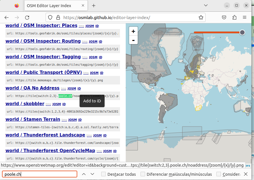
But one problem is, while some of them already exist, except by JOSM (which needs more explaining, but still very hidden) on iD even the existing ones aren’t point and click or broken. So while here is discussed the idea of make on the tiles or not (which I think would be accepted at all on the Carto because it is aimed to be general purpose) the hints that data is missing is very, very hidden.
Ok. I get it that this is not a new complaint. And also that in previous interactions, more people agreed that this was important, and is not growing fast enough, but is improving.
But even if we ignore for a moment the idea of hidden the elements from Carto (which I think would not be helpful at all from an usability point of view, because seems better to just make very clear where there’s missing information, but this tends to be done with other layers or maybe icons), even on the editors, this kind of QA layer is either too hidden or broken.
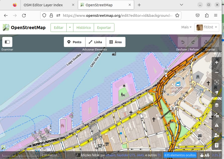
And in the case of street names, we here do have a layer with the names based on government data, but this layer alone cannot be used to know the missing parts where there’s no name. And quite often, similar to what would happens with surface=* in motorways, lack of name happens on several small parts, which is not possible to see.
PS
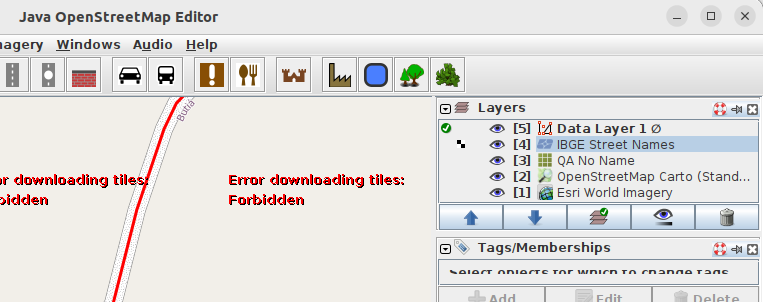
Edit: One additional reason for use it on iD is because some layers will only load on iD editor, because they started to require API keys. So for example, the current layer in Brazil for street names will be “Error downloading tiles: Forbidden”.
So, by a combo of circumstances, the editor which have the names is not the editor which (even if need far more clicks) have the very clear signal of roads with missing names
I can’t remember the name of it right now, but there was a map/QA tool years ago for cleaning up Tiger data in the United States where roads that hadn’t been “fixed” yet were displayed in red and the color turned blue once someone edited them. Or maybe the colors were reversed. It’s been a while. Either way, it would be interesting to see if something like that could be implemented in as option/overlay in iD Editor or really as a separate style from Carto on the main website to display which objects have been “completely” mapped and/or need updating. Doing it in iD Editor is probably the better option for various reasons though.
Being described directly above is TIGER Edited Map - OpenStreetMap Wiki by ITO World. Now defunct, it is sorely missed (by many) as it really did create an excellent real-time perspective with well-chosen “aging” of TIGER data and a color scheme that worked well: red for the most urgent, never-touched ways, various shades of blue for those which were edited recently or were considered fully reviewed (and more). See that link and zoom way in on the “Missouri” example graphic and you can actually read the rules for which colors were chosen. Other TIGER cleanup (BattleGrid et al) tools exist(ed), though in my opinion ITO World’s version couldn’t be beat.
I’ll say it again, I really miss this rendering, but I understand that (such) fresh tiles don’t come free (other raster tile renderers, like Carto, do, but that is an almost magical illusion that is part of the wonderfulness of OSM’s ecosystem — so much so that many mistakenly confuse Carto tiles for OSM itself). Fixing up TIGER data, while a real problem that remains (and will for decades, by wide acknowledgement) for USA mappers, can still be done with (unfortunately, techy/wonky) well-crafted Overpass queries (which I use sparingly, as THOSE compute cycles don’t come for “free,” either). But there is nothing like an excellent visualization / rendering for such QA. If somebody were to replicate the ITO World tiles (somehow), it would reduce “decades” to (only) “several years,” I’m sure.
I’m not sure it would be (immediately) correct implementing this in iD or something like a “Carto toggle” (which it wouldn’t be, but I’m coining what might be easy to “switch on” but with likely a fair bit going on under-the-hood), but a “simple” rendering like ITO World’s “/map/162” (the defunct TIGER Reviewed tiles) would go a long way. Plus, TIGER Review is a USA-only thing. I’m sure there are other QA needs in our map (data) which fall under the aegis of “wide area” (enough to warrant such a big solution) and “we need to.”
Though, the point remains: being able to “whip up” a renderer, or an “integrated into your editing tool at the flick of a switch” layer that enables wide-area QA is very powerful fuel (coupled with the good spirit of OSM and our natural crowdsourcing) for directly achieving medium- to longer-term goals in our map (data). Yes, these are technical and require real effort to produce, but we will get better at them as we spin up more of them. So, some of us should either be busy talking about this, doing it, or both. Thanks for reading.
Huh. Steve’s plan for OSM hasn’t changed since 2012, in eleven years! He used the same premise in his 2014 Board elections. Only now it’s hard to not feel a subtext of “we hired you as the OSM guy, why map not good yet”.
Not a strategy by definition, and certainly not something that would benefit OSM on the long run. But I’m a tiny bit positively surprised with productive replies from the community (I expected it to just be ignored due to that there’s nothing to add to previous discussions).
(my answer is almost entirely unrelated to Steve Coast’s proposal for OSMF strategic plan, and may benefit from its own thread)
Is this something that has been raised with the JOSM developers? Other layers used by JOSM use API keys, so I’d have thought that the IBGE one could be handled in the same way. You can raise a JOSM issue from within JOSM itself, and if you do that it’ll capture the context of exactly what you were doing. I’ve always found the JOSM devs very responsive to issues raised with them.
(my answer is almost entirely unrelated to Steve Coast’s proposal for OSMF strategic plan, and may benefit from its own thread)
I’d suggest that the second of those is more likely to have a positive impact than the first
From where I’m sitting, I’m rather surprised that no-one has picked up the baton from where ITO World (a small UK company in Ipswich) left off. There are a bunch of possible ways of solving the problem. The wiki mentions Overpass and Sophox - I’d have thought that it would also be possible to use uMap for this too.
For a “complete” replacement of the ITO TIGER fixup layers it would certainly be possible to create a set of raster tiles containing only the data that you were interested in on a transparent background. Most of what you’d need to do is here. It wouldn’t be that much data, even for the whole of the US. Taginfo suggests 11,000,000 tiger:reviewed objects in total, which is a good deal less than the total number of keys in Britain and Ireland, which is a handy comparison because I know that that fits nicely onto a €1-a-day Cloud server, so not a huge outlay. All of the management scripts for that are in github, so you wouldn’t be reinventing the wheel, just duplicating (and simplifying) the configuration, and creating your own map style to show the data you want. Writing the style itself doesn’t need to involve impenetrable database and CSS code, since osm2pgsql (the thing that you’d load the database with) supports lua tag transforms like this that makes it really easy.
I don’t like dismissing something because it has been said before, or because it comes from a certain person, or because there are bad ideas mixed in with the good ones.
The ideas in Steve’s proposal are worth discussion for what they are - a collection of ideas. I disagree with many (e.g. Local Chapters being asked to fund the OSMF) but also agree with some. I think anything that makes osm.org more of a welcoming place that encourages good new mappers is a great idea. OSM has become too fractured it now places so much emphasis on the individual to find all the useful tools / websites / apps that make you a good mapper. Anything that changes this is good in my opinion.
I can tell you why I don’t. First the technical challenge as it’s not my natural skillset. Having said that, I can find my way through if I need to, it’s just a lot of effort for me. Which brings me to the main reason: discoverability. If I create something I want people to be able to easily find it so that it gets maximum use. This is now really hard in OSM. You end up with people like Ivan writing up a list as a diary entry, and even then he admits he “certainly forgot many”.
It has been years since osm.org last got a major change. We should consider whether it is functioning well at attracting new mappers and helping them become good mappers. That means attracting people who don’t have endless time to trawl through endless websites, collecting lists of which ones are helpful and figuring out complex steps (e.g. any overpass query beyond the wizard) to help them with their mapping.
We should be aiming to increase the number of mappers by making it easier and fun. For the UK a target of 1 person per 100,000 population mapping per day seems like a good starting point. That means more than doubling our current level.
P.S. 100,000 is the population of a place like Worcester. Surely we can aspire that at an average of one person from Worcester contributes to OSM daily? That could be as simple as 365 residents of Worcester contribute to OSM just once a year!
Aside from everything you’ve said I’ve always thought the idea of OpenStreetMap farming out everything except basic features to other websites was a bad one, because the chance of a new user returning to the main site once they have left for another site that is only tangentially related to editing open street in iD Editor on the main site is probably pretty slim. Plus it builds engagement for those other sites. Sure, edits in RapiD might be feedback into the database, but then people who use it get habituated and won’t use regular iD Editor on the main site.
Same goes for a site like MapRoulette. The database gets edits from it, but people will just continue MapRoulette and never log into the main site because there’s no reason to. It’s a weird way thing to do things. Not to say other sites shouldn’t be able to access the database or feedback information to it, but the main site and instance of iD Editor should at least strive for some kind of feature parity with the competition (maybe that’s the wrong word, but I’m not sure what else to call it). Otherwise, it might as well just be a glorified file host for planet files. It’s not going to bring anyone in or let alone retain them when iD Editor feels and looks like an early beta version of RapiD though.
Some people have proposed to me in direct messages that this thread be split into multiple. What do the participants of this thread think, and if you agree how would you folks split it up.
Yes he did Simon. You may not agree with his ideas, but several of them were directly related to this. As an example:
“map quality features will be built in to osm.org”
Best to take Steve as a person out of the discussion as clearly some people have an issue with his history in OSM. The real question is, which ideas are worthwhile. In my view there are several good ideas in the original post and in the subsequent discussion.
I do agree that it is reaching the point where there are too many allusions to Steve as a person. Of course, given his status as an originator of the OSM project and that the title of this thread literally concerns Steve’s alternative proposal for the OSMF strategic plan, it will be more difficult to fully disentangle positions from the person when leveraging criticisms.