I’d be interested to know what people are using to tag soft and boggy paths, particularly with a view to suitability for cycling.
In the uplands of mid-Wales, there are numerous paths which are legally accessible to bikes, but in practice are very hard going even on a mountain bike.
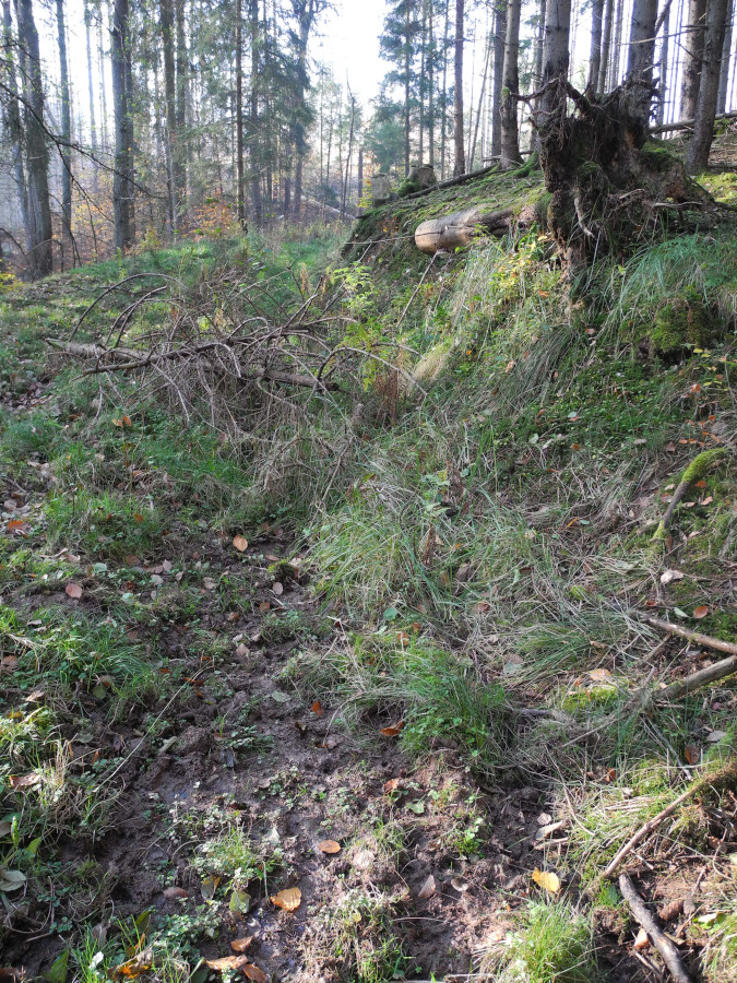
Often these have a soft surface which is ok for walking (assuming you have good boots), but a bike will just sink into it. It might be obviously boggy/wet, or it might be more “tussocky” - “a compact tuft especially of grass or sedge, also: an area of raised solid ground in a marsh or bog that is bound together by roots of low vegetation”.
There isn’t an obvious surface tag value. mtb:scale is more about technical ability - obstacles and gradients - than about paths which are just difficult going by virtue of their surface. Similarly tracktype and smoothness are mostly about the roughness of the surface. I’m a bit stumped and I suspect most other mappers are too, as I haven’t seen anything widely in use for this sort of path (in the UK, at least).
tracktype is mostly about surface firmness, so it would help, but not sufficient. It seems we don’t have enough surface tags Surface:mud seems close enough?
I am carrying the same subject in my bag “needs clarification” … just not yet put into writing so far. We have similar tracks in our region here - not in the open grassland but more in forest areas. Tracks which are subject to constantly trickling water, following the track for some distance and then finding another way down to the next stream. Depending on weather conditions these tracks are soaked with water for many month and drying only in longer periods of dry conditions. Hard to walk and even worse to ride a bike.
Another issue are tracks covered by dry wood, scattered over the way sometimes in many layers and nearly impossible to ride by bike unless you are a pro. This deadwood problem has significantly increased over the past few years due to the hot and dry summers causing great damage to our forests.
My idea for these issues was not to define further surface tags but to make use of the obstacle key instead. For the given examples (in the opening post an above):
surface=ground + obstacle=bog or swamp
surface=grass + obstacle=tussock
surface=ground + obstacle=deadwood
and the like. I am aware the obstacle key acutally is not that much in use but it could be helpful to describe such environmental features in addition to the surface and smoothness tag imho.
I’ve used surface=mud for a trail that was built just before a wetland restoration project was more successful than anticipated. (The trail in question is underwater during spring and early summer, and is only really practical in winter, once the ground freezes.)
I’d use surface for (whatever fits the surface - maybe grass or dirt here), and I’d use smoothness to try and show how hard it is to navigate with a wheeled vehicle. It’d not perfect, but it is at least a scale that allows you to compare places with each other.
As an example of the problems, the section of track here has been mapped with smoothness on a “how easy would it be to drive a car” basis (as described n the wiki), and unfortunately the difficultly in cycling it doesn’t map perfectly only that - on the “bad” sections at the south end you can just cycle around the potholes, but the “intermediate” sections to the north are worse on a bike because you can’t.
The other bit is the “may get boggy” part of the question. This is orthogonal to flood_prone, and I’m not sure OSM has a good tag for it. There are lots of notes and descriptions containing “boggy” though.
I think we need a separate softness tag to be used alongside smoothness with similar implications from surface. For me soft beach sand is probably the softest “dry” surface I’ve encountered. It can be surprisingly tiring to even walk over and I wouldn’t expect a typical bike to have any chance, the “fat tyre” ones might even struggle. Oddly has the opposite effect to mud generating soils when wet and tends to firm up until actually underwater, but I digress.
Would it be worth tagging firmness in the dry and wet separately? I know they use a scale for the day’s track conditions in horseracing but I don’t really think that’s a good starting point for OSM.
The problem with a surface tag for “can get a bit boggy” is that there might be some other entirely valid surface tag tat can also apply (dirt, grass, and in a few bits of riverbank near me, concrete).
Another option might be something like hazard, but the values there are a bit of a hotch-potch.
Maybe, but as you noted earlier there isn’t really anything properly established for that sort of thing there. I’d be more than happy to support any suggestion - currently the web maps I create use wider spaced dashes to “de-emphasise” certain paths for various reasons. Currently obstacle=vegetation is one of those, as is informal=yes and low trail_visibility.
I have yet another variant of the essentially same problem of describing surface softness (under certain conditions). Since this discussion thread was pretty much the only one (!) on the topic I was able to find with googling I thought it would be better ask here than start a new thread.
I Finland we have multiple types of highways (unclassified, service, track), in practise typically smaller (forest) roads that are smooth and fast for biking when dry or when ground is frozen (with or without snow). However in spring, autumn and sometimes even summer time after heavy raining they turn so soft that they practically “suck” the tire and rolling resistance becomes enermous.
I have been reviewing various tags but nothing seems to fit. obstacle:mud clearly does not, because this is not a permanent condition and these areas are not swamp / wetland.
A similar situation that we do have a tag for is flood_prone=yes. The situation described in this thread is clearly not flooding but it does seem to be about ways that are “prone” to being soft, boggy, or mucky and not necessarily on a predictable seasonal schedule. muck_prone sounds rather awkward, but perhaps someone has a better idea for a key name that would carry this meaning.
With the GPX traces layer on you can see how far I ventured along the track before the overall dampness became too much (didn’t help that the soles of my Goretex boots had just come asunder). My guidebook was pretty firm that one could encounter a lot of water, thigh-deep on this track in the Spring. Obviously the park has large tracts of marshy ground anyway, but the example shown was soft and slightly damp, not wet at the time.
The most popular walking website in Scotland, Walkhighlands.com uses the following classification scheme, for the “bog factor” of a path.
| 1 | Walk is usually completely dry underfoot. |
| 2 | The route may be slightly boggy in places. |
| 3 | Much of the walk may be dry, but there are sections which can be very wet. Waterproof boots recommended. |
| 4 | Underfoot conditions are likely to be very wet in parts all year round. |
| 5 | It’s a swamp. Snorkel recommended. |
This is orthogonal to the “grade” of a path which roughly corresponds to our sac_scale and trail_visibility.
We could adapt this, though we’ll probably need something less tongue in cheek than bog_factor=snorkel_recommended. We could ask the creators of Walkhighlands, I hope they wouldn’t mind. We would need to make some changes anyway, as it’s meant for long walks.
The scheme refers to something between average and worst case conditions. Common sense is advised, “can be very wet” refers to periods after heavy rainfall, etc.
It basically answers the question if you need boots, maybe even gaiters, to avoid getting your feet wet.
There is some correlation with surface: all forms of paved probably imply a value of 1, in Scotland surface=earth/dirt/ground tends to imply 2 or higher, and surface=mud probably corresponds to a 4 or 5. But as others have pointed out, this would also be useful for grass, sand and others.
That tracktype=grade5 indicates it is soft (meaning, when the rains come, it will also quite likely turn to mud - and surface=ground is unspecific enough to cover both dirt and mud and grass depending on the season)
I’m considering writing a proposal that includes deprecation of tracktype and including its grades values into the surface key so that a very soft surface can be tagged with surface=grade5 This could solve this issue too. Just need some time to write down the proposal…
Deprecating a feature is anything but“just need some time”. It’s like saying that humans “just need some time” to terraform Mars. Technically true, but highly misleading.
See part about deprecation in “Due Dilligence” section of Proposal process as well as “Everything is more complicated than expected” section of deprecated features to get a sense about enormity of the task (writing proposal itself is literally laughably small percentage of work that needs to be done to successfully deprecate a feature without casing major issues).
Also note that there is a huge difference between for example surface=grass + tracktype=grade5 and surface=mud + tracktype=grade5, so it would not be a good idea anyway.
Here, I’ve just saved you some time; can use it to go grab some instead!
I have understood tracktype (esp. 4 & 5) to indicate the surface of the track. However how wet and soft the track becomes when it rains depends also / a lot on the underlying layers (do they let through quickly or block the water). Thus using this combo of tags is probably the best alternative right now, but I’m not sure how uniform the existing tagging is and would it properly indicate track softness when raining.