I have already received related information from a Japanese friend. I have also seen BRTs in each country. This time, Sebu is also building a BRT, and it is in the same style as Korea. It is installed on existing roads, not in separate lanes.
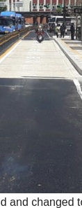
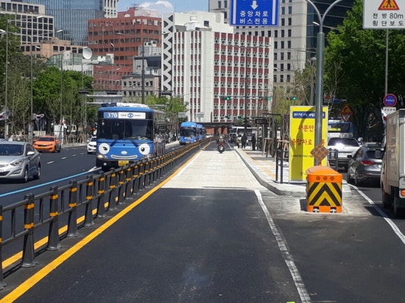
As for why Korea’s BRT looks like this, there are buses that use the BRT all the way to the end, but there are no fences outside because they merge at a different area. So, the local government installed the fence only in the middle, so that you can join at the blue line
Please, because each country’s road standards are different, the road standards should be changed so that they can be mapped to each country’s standards. It’s hard to change rules for long-term data, but if we come here to discuss it, it’s because there was no response from the Korean OSM forum.
adjusting guidance so it fits given country is fine - for example Highway Tag Africa - OpenStreetMap Wiki explains that highway=primary or even highway=trunk may be unpaved. This one is not even changing road standards guidelines.
starting to use say highway=motorway for all scenic roads would be terrible idea, mapping bus lane as separate carriageway would be a bad idea
You keep saying it can’t be done, but Sebu is also installing a BRT like Korea. If you can’t express it in detail in the future because of those regulations, you won’t be held responsible, right?
What specifically can you not express using current tagging guidelines? Is there something in particular about these Korean (and proposed Sebu) systems that is different from everywhere else? (Not necessarily under the name “BRT”).
which detail cannot be expressed by existing bus lane tagging?
(if there is language barrier that makes discussion harder, then maybe you can start threat at Korean section of forum? maybe linking this one? You mentioned that noone made such thread there so far.)
So, since Korea’s BRT does not have separate lanes and each country’s road standards and systems are different, the road rules need to be revised to install BRT.
What is so special about bus lanes (BRT) in Korea that it cannot be mapped using established mapping rules?
Special mapping rules only make sense if something is different than in other countries.
So, if I understand correctly, you claim that the moderators of the Korean community here in this forum won’t hold a conversation about the separate bus lane mapping issues?
I don’t know the full situation, but I would assume that, based on the photos you provided, if the bus lane is separated by the rest of the road with only paint, it shouldn’t be mapped as separate road but be tagged on the existing highway as lanes:bus or something similar. It should be mapped as separate road only if that bus lane has railing barriers on both sides, I assume.
From the perspective of users of Korean OSM, BRT is not a separate road but is installed on an existing road, so it cannot be displayed separately. That one reason…
I don’t think it’s a problem. And the reason there are no guardrails on both lanes is because there are buses that use the entire BRT lane and there are bus routes that merge in the middle, so the local government didn’t install them.
What is a BRT and what is not is subject to definition, which can be country-specific. BRT is a type of service and way of operation; to achieve the set timetable, it is usually required to create separate infrastructure, though it is not required.
If you want to add the route that a specific bus will take, you can do so via relations: Buses - OpenStreetMap Wiki. This relation can be named “BRT line XYZ” or whatever fits best.
Another topic is the infrastructure, i.e. what is actually on the ground. Is there a physical barrier? Map the roads separately. Is there a marking that legally prevents lane changes? Use Key:change - OpenStreetMap Wiki, but it’s a single way. Are the lanes marked (e.g. bus only), use Key:lanes - OpenStreetMap Wiki
None of the infrastructure prevents a certain mode of operation - indeed, that changes all the time. Sometimes, a distinction can make sense (see railway=tram vs railway=light_rail), though that’s nothing country specific.
(I really missed a lot of talk but this is a topic I’m very interested in.)
To start: I’m from Germany, a country which doesn’t do real BRTs. That means, busways are typically combined with tramways and only rarely are they standalone (and the most rare are bus guideways), and more importantly, we don’t even “know” what a BRT, it’s all city buses to us![1]
However, this also is true for OSM: Outside of the initial idea of highway=busway (which strongly talked about BRTs in its introductory paragraph but that got changed half a year ago since that’s too specific compared to the rest of the article which talked about bus ROW in general and thus has been generalised since then), the concept of BRT also is unknown on OSM i.e. there are no established tags whatsoever which tell you that a bus system is BRT. All you can tag for buses is which lanes are reserved for buses or if there ROWs which are built for buses but not which routes are BRT.
The punchline is that isn’t a BRT issue as much as a mapping issue, one which isn’t Korea-exclusive either as I’ve seen multiple roads on OSM which are tagged as dual carriageways but are single carriageways in reality[2] or had their lanes tagged separately [3] and also fixed countless other single-carriageways-as-dual-carriageways[4].
tl;dr You’re confusing between infrastructure (i.e. bus lanes, busways) and service (BRT) and put the blame onto an innocent party instead of whoever mapped the bus lanes.
This doesn’t mean we don’t do different services because some cities and regions do you classifications such as express buses (limited stop at least inside cities) and metrobuses (not BRT but regular buses of major importance like higher frequency and 24/7 operation) but a city with a BRT line? Not really. ↩︎
Darmstädter Landstraße in Frankfurt used to have its left turns mapped separately before I fixed it myself↩︎
Friedberger Landstraße, also in Frankfurt, for another recent example I fixed thanks to the tramway but that too is not a physical separation and there are other roads like this which need to be fixed ↩︎